Flight Operations
Non-Towered Airports: Reading the Ground Before You Launch
At a field with no tower, the airport itself tells you which way the traffic is flowing. You just have to know how to read it.
Key takeaway
Read the wind indicator first to find the active runway, then read the pattern indicator to find which side the traffic flies on. The extended centerline off the approach end is the worst place to stand.
At a field with no operating control tower, nobody is going to tell you what the traffic is doing. The airport tells you instead — through the wind indicator, the segmented circle, the runway markings and the pattern itself. All four are readable from outside the fence, and together they tell a remote pilot the one thing that matters: where the manned aircraft are going to be.
Start with the wind, because the wind sets everything else
Aircraft take off and land into the wind. Find the wind and you have found the active runway; find the active runway and you know which end of the field the arriving traffic is descending toward.
Three devices show it, and all three are placed where they can be seen from the air:
| Indicator | How to read it |
|---|---|
| Wind sock | Streams downwind, away from the wind. The straighter it flies, the stronger the wind |
| Tetrahedron | The pointed nose swings into the wind, showing the direction to land |
| Landing tee | Land in the direction the shaft of the tee is pointing |
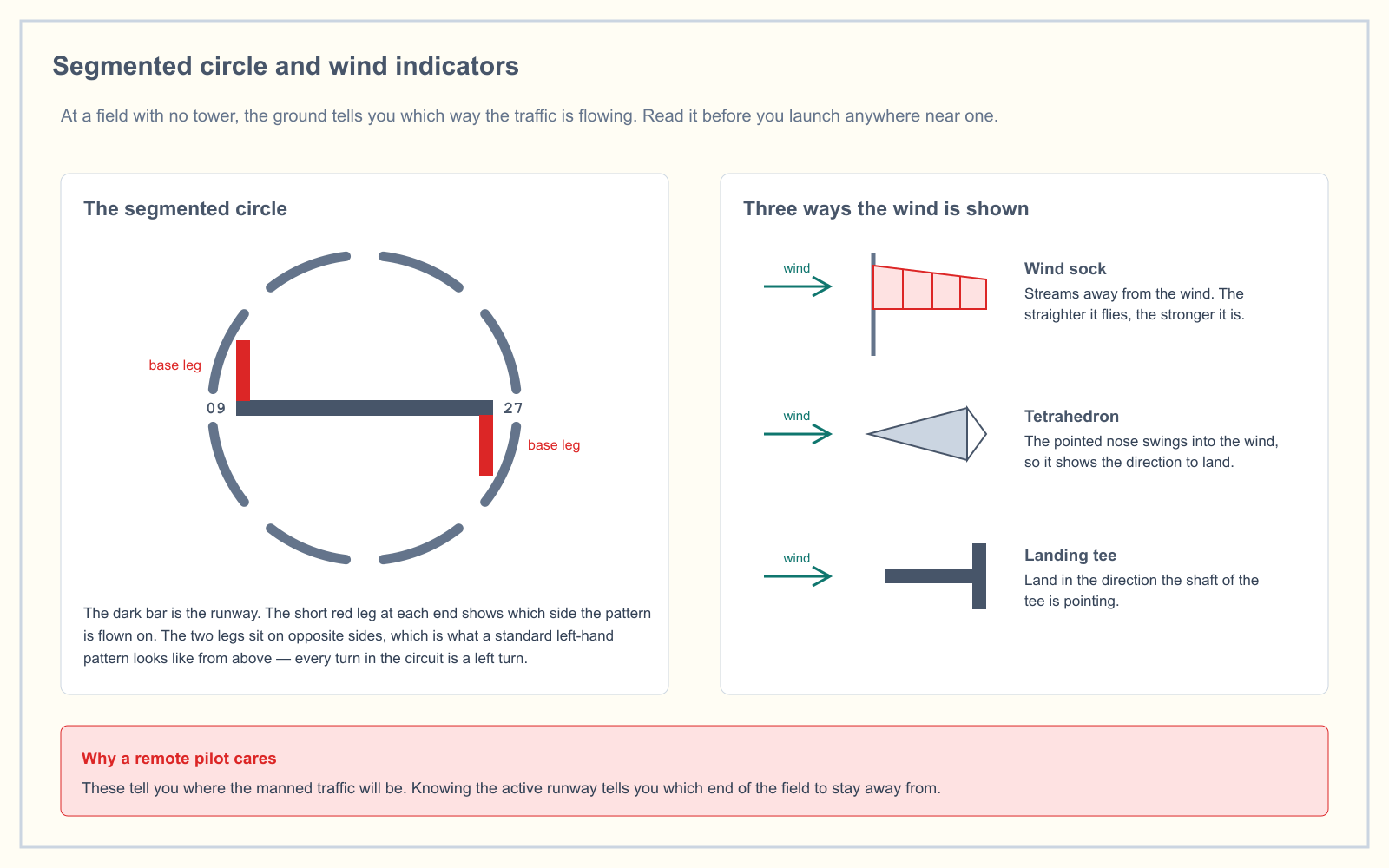
A caution about the tetrahedron: it shows landing direction, but it can be manually positioned, and the AIM notes it should not be relied on as the sole wind indicator where a sock is available. If a sock and a tetrahedron disagree, believe the sock.
The segmented circle
The segmented circle is the ring of white segments laid out on the ground near the center of the field. It exists to hold the wind indicator and, more usefully, the landing strip indicators and traffic pattern indicators.
- The landing strip indicator is a bar showing the alignment of a runway.
- The traffic pattern indicator is a short leg extending from the end of that bar, showing which side of the runway the pattern is flown on.
In a standard left-hand pattern the two legs sit on opposite sides of the runway bar, because the pattern for one runway direction is a mirror of the pattern for the other. If both legs are on the same side, you are looking at a field where one direction has a right-hand pattern — which is exactly what the sectional's airport data block would show as RP followed by the runway number.
The traffic pattern
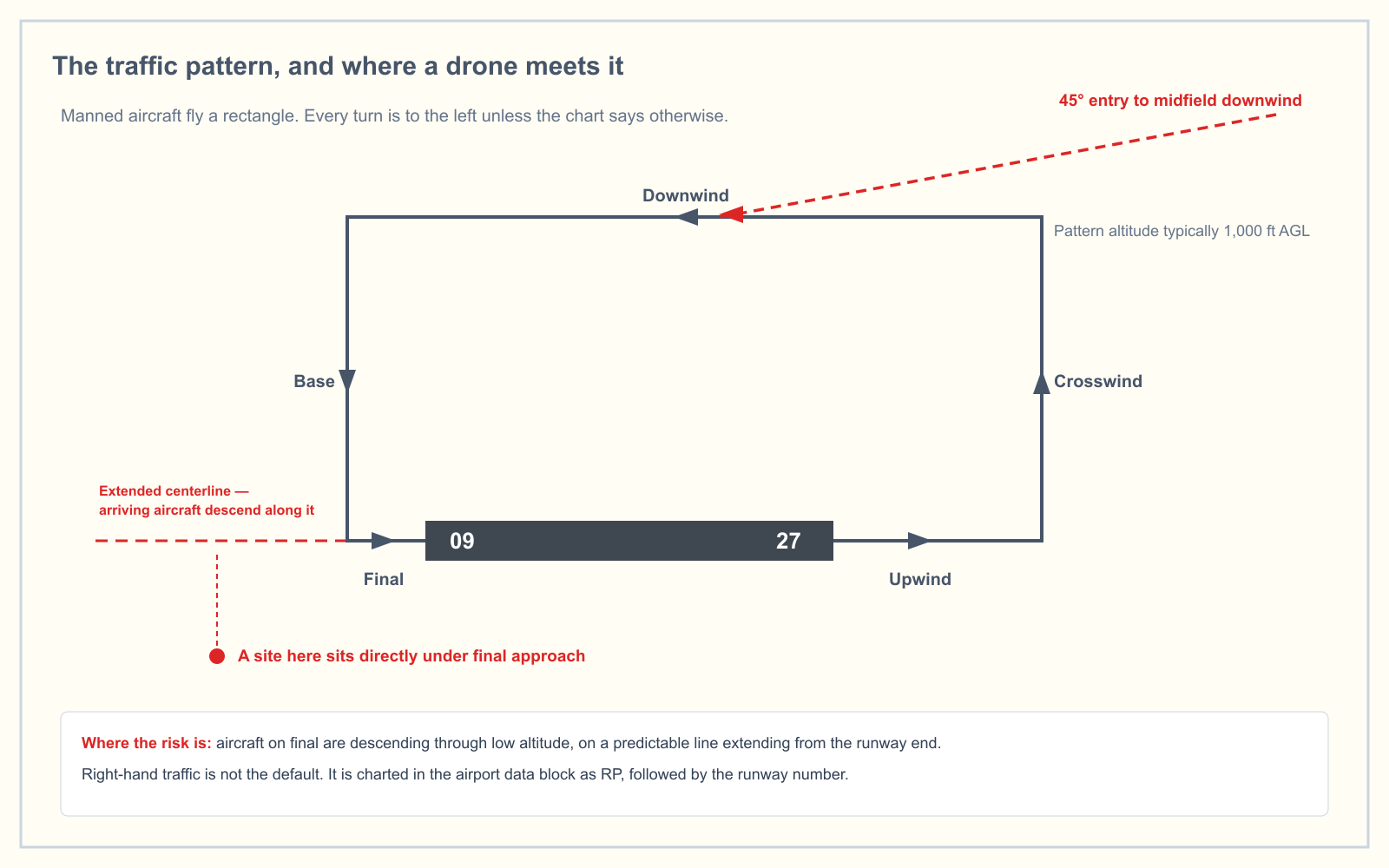
Every turn in a standard pattern is a left turn. Right traffic exists, but it is the exception, it is charted, and it is never the assumption.
| Leg | What the aircraft is doing |
|---|---|
| Upwind / departure | Climbing straight out on the runway heading |
| Crosswind | First left turn, climbing to pattern altitude |
| Downwind | Parallel to the runway, opposite direction, at pattern altitude |
| Base | Turning toward the runway, descending |
| Final | Aligned with the runway, descending, lowest and least maneuverable |
Pattern altitude is typically 1,000 feet AGL for propeller aircraft, though it varies by field and is published in the Chart Supplement. Arriving aircraft normally join at midfield downwind on a 45-degree entry.
For a remote pilot at 400 feet or below, the numbers look reassuring — you are 600 feet under the pattern. The problem is not the downwind leg. It is final, where an aircraft descends from pattern altitude to the runway along a predictable line extending from the approach end. Somewhere on that line the aircraft passes through your altitude, and it does so where a landing crew has the least ability to maneuver.
That is the single most useful operational takeaway: the extended centerline off each runway end is the worst place to set up.
The runway itself
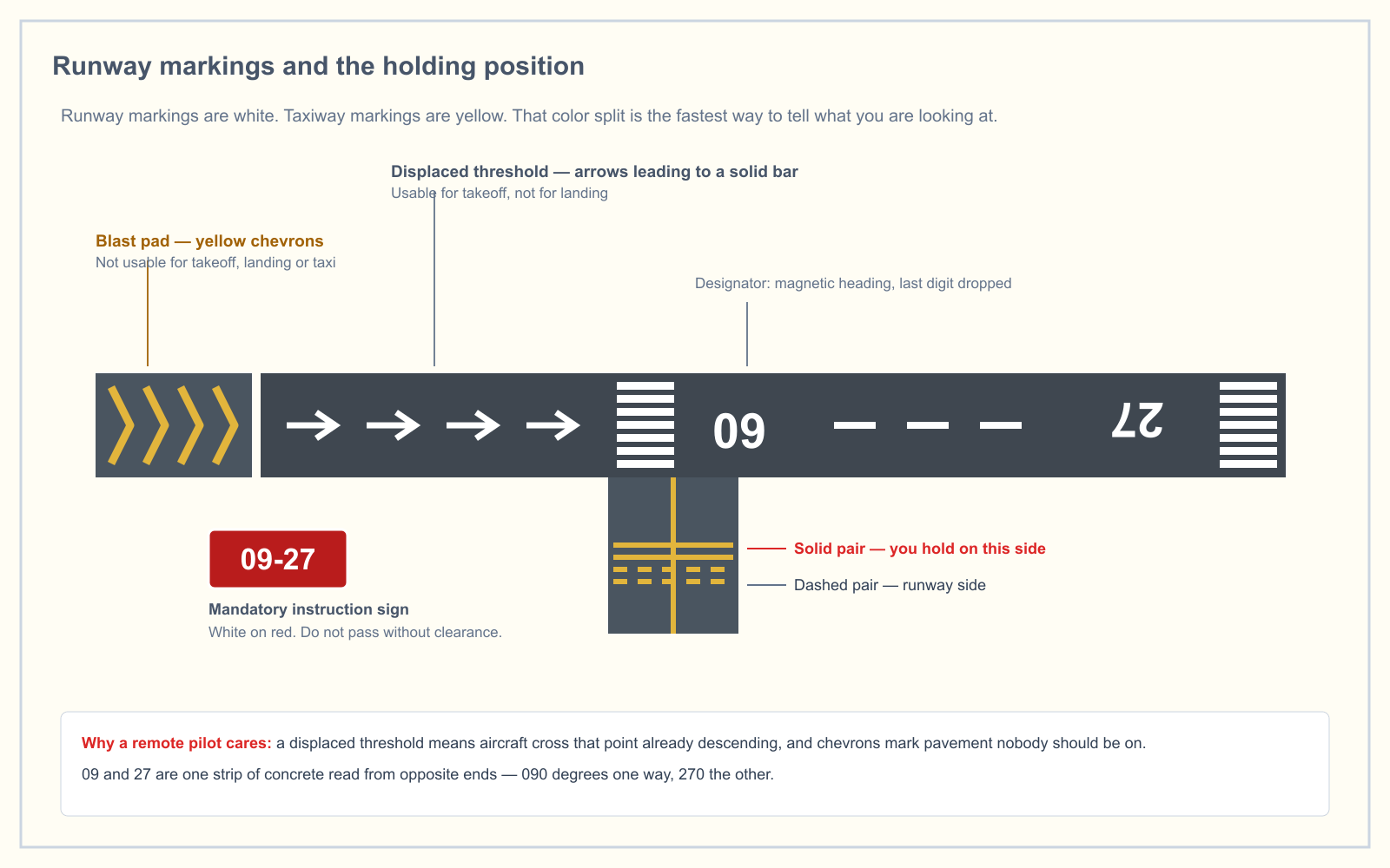
Runway numbers are the magnetic heading of the runway, rounded to the nearest 10 degrees, with the last digit dropped. Runway 09 points roughly 090 magnetic; the opposite end of the same strip is runway 27, pointing 270.
A few conventions worth knowing:
- Runway markings are white. Taxiway markings and boundary lines are yellow. That one split covers most of what you need.
- A displaced threshold marks pavement not available for landing, though aircraft may use it for takeoff or rollout.
- Chevrons mark pavement not usable for any normal operation — not landing, not takeoff, not taxi.
- The holding position marking is two solid yellow lines and two dashed yellow lines. An aircraft on the taxiway side never crosses it toward the runway without a clearance. For a drone crew, treat it as the edge of the movement area.
Radio: listen, and think hard before you transmit
At a non-towered field, aircraft self-announce on the CTAF — the common traffic advisory frequency, shown on the sectional in the airport data block, marked with a white C in a solid circle.
Monitoring the CTAF is one of the most useful things a remote crew can do. It tells you which runway is in use, who is inbound and from where, and when somebody is on final.
Transmitting is a different question. Part 107 does not require a radio and does not authorize you to inject yourself into the traffic flow. A remote pilot broadcasting position reports on CTAF adds an aircraft to the mental picture of every pilot listening — one they cannot see and cannot separate from. The general guidance in the FAA material is to monitor rather than transmit unless there is a specific reason and you know the phraseology.
The rule that does apply, always, is 14 CFR 107.37: yield the right of way. A small unmanned aircraft must give way to all other aircraft. There is no situation in which the manned aircraft is expected to move.
A workable pre-launch routine near a non-towered field
- Check the sectional for the airport data block: CTAF, field elevation, runway lengths, and any RP notation.
- Confirm the airspace at your launch point, not at the airport. Class E starting at 700 feet AGL over your site does not require authorization; a dashed magenta surface area does.
- Find the wind indicator and identify the active runway.
- Read the pattern indicator and work out which side the traffic is flying on.
- Set up off the extended centerline of both runway ends, and outside the pattern if the geometry allows.
- Monitor CTAF for the duration of the flight.
- Brief the visual observer specifically on where arriving aircraft will appear from.
Frequently asked questions
What is a segmented circle at an airport?
A segmented circle is a ground marking near the center of an airport that holds the wind indicator and displays landing strip indicators and traffic pattern indicators. It tells an approaching pilot the runway alignment and which side of the runway the traffic pattern is flown on.
What are the legs of a traffic pattern?
The legs are upwind (or departure), crosswind, downwind, base and final. In a standard pattern every turn between them is a left turn, and downwind is flown at pattern altitude, typically 1,000 feet AGL.
How do you know which way the wind is blowing at an airport?
A wind sock streams away from the wind, so the wind comes from the opposite direction to the one it points. A tetrahedron's pointed nose swings into the wind and shows the landing direction, and a landing tee indicates the landing direction with its shaft.
What do runway markings mean?
Runway markings are white and taxiway markings are yellow. A displaced threshold marks pavement unavailable for landing but usable for takeoff or rollout, and chevrons mark pavement not usable for any normal operation. The holding position marking — two solid and two dashed yellow lines — is the boundary nothing crosses toward the runway without a clearance.
Should a drone pilot transmit on CTAF?
Monitoring CTAF is valuable and widely recommended. Transmitting is generally discouraged unless there is a specific reason and you know the correct phraseology, because it places an aircraft into other pilots' mental picture that they cannot see or separate from. Part 107 does not require a radio.
Where should you not set up a drone near an airport?
Avoid the extended centerline off either runway end. That is where arriving aircraft descend through low altitude on a predictable line, and where a landing crew has the least ability to maneuver around a hazard.
Airport operations sit in the Operations knowledge area, 25 percent of the Part 107 exam. See how you score with the free readiness assessment, or work through chart-reading directly in the sectional chart trainer.
Sources
Put this guide into practice.
Take the free assessment to see how this topic fits into your current exam readiness.
Start free practice