Weather
How to Read a TAF: The Terminal Aerodrome Forecast, Group by Group
A TAF is a forecast for a five-mile circle around an airport, not a report of what is happening at your launch site. Here is every group, and what each one means for a Part 107 flight.
Key takeaway
A TAF forecasts conditions within 5 statute miles of the airport's runway complex. It is a planning tool, not the legal determination — 14 CFR 107.51 requires 3 statute miles of flight visibility measured from your control station.
A TAF, or Terminal Aerodrome Forecast, is a coded forecast of the weather expected within 5 statute miles of the center of an airport's runway complex. Most are valid for 24 hours and are issued four times a day, at 0000, 0600, 1200 and 1800 UTC. It uses the same codes as a METAR, plus change groups that split the period into blocks.
That last part is where candidates lose marks. A METAR describes one moment and reads straight through. A TAF describes a whole day, and the change groups mean the line you are looking at may not apply to the hour you care about. Read the wrong block and you will confidently give the wrong answer.
Here is a complete routine TAF:
TAF KGGG 121120Z 1212/1312 18010KT P6SM SCT025 BKN040
     FM121800 20014G22KT 5SM BR OVC008
     TEMPO 1220/1224 2SM TSRA OVC008CB
     FM130200 24008KT P6SM SCT030
     PROB30 1304/1308 3SM SHRA BKN015
Decoded, line by line:
| Group | Meaning |
|---|---|
TAF | A routine forecast. TAF AMD is an amendment, TAF COR a correction |
KGGG | The station the forecast is for |
121120Z | Issued on the 12th at 1120 UTC |
1212/1312 | Valid from the 12th at 1200Z to the 13th at 1200Z |
18010KT P6SM SCT025 BKN040 | Wind 180 true at 10 knots, visibility greater than 6 SM, scattered at 2,500, broken at 4,000 |
FM121800 | From 1800Z on the 12th, everything changes to what follows |
20014G22KT 5SM BR OVC008 | Wind 200 at 14 gusting 22, 5 SM in mist, overcast at 800 feet |
TEMPO 1220/1224 | Briefly, between 2000Z and 2400Z on the 12th |
2SM TSRA OVC008CB | 2 SM in a thunderstorm with rain, overcast at 800 with cumulonimbus |
FM130200 | From 0200Z on the 13th |
PROB30 1304/1308 | A 30 percent chance, between 0400Z and 0800Z on the 13th |
What a TAF is, and how it differs from a METAR
A METAR is an observation. Somebody or something measured the weather and wrote it down. A TAF is a forecaster's prediction of what will happen over the next day.
The second difference matters more for how you use it. A METAR reports conditions at the observing station. A TAF, per National Weather Service Instruction 10-813, covers the area within 5 statute miles of the center of the airport's runway complex. It is a small circle, and it is drawn around the airport, not around you.
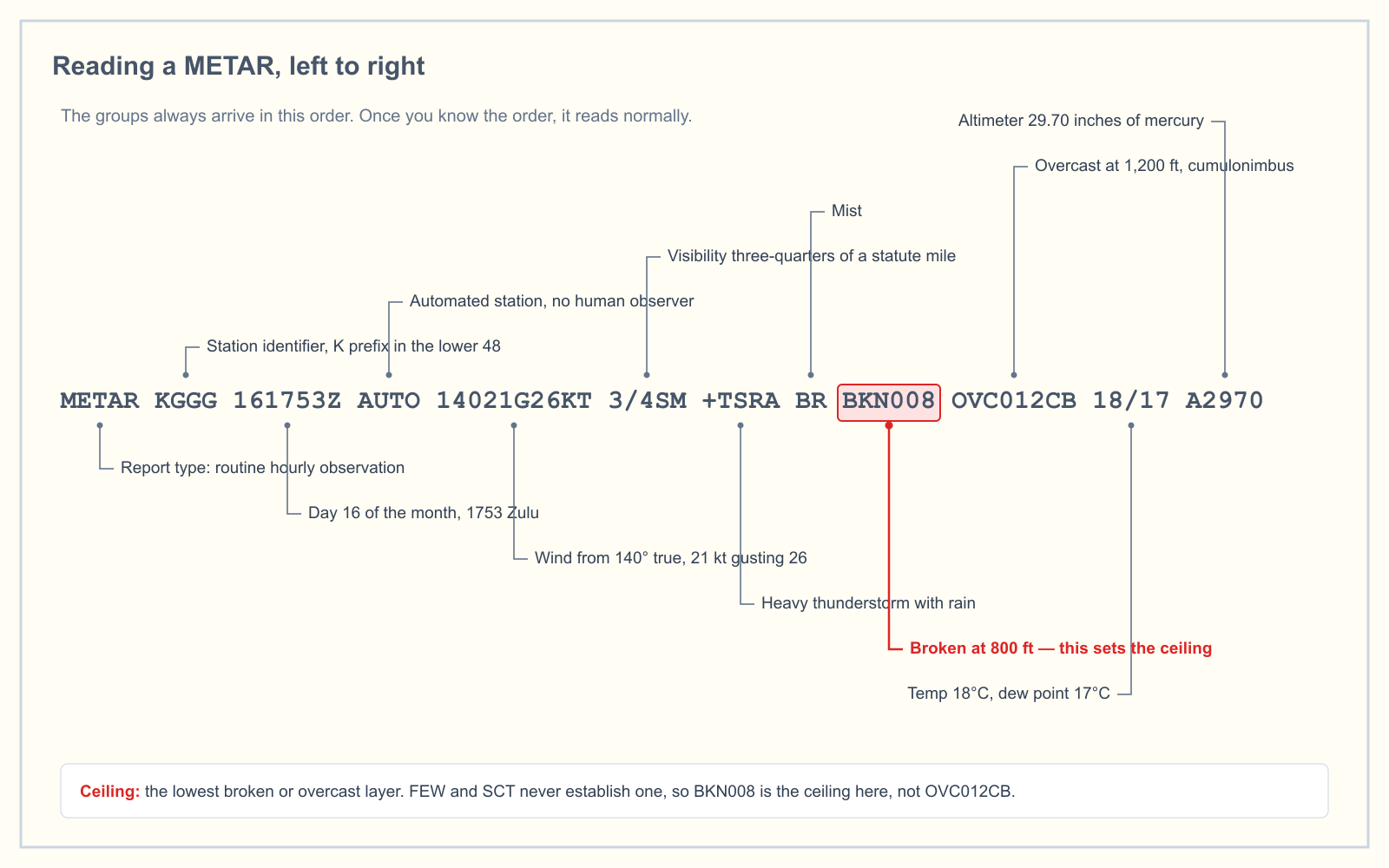
The codes themselves are shared. Wind, visibility, present weather and sky cover are written identically in both. If you can read a METAR, you already know most of a TAF. What you have to add is the header and the change groups.
The header: station, issue time and validity period
Three groups, and each has a trap.
The issue time (121120Z) is when the forecast was written, not when it starts. Scheduled TAFs are issued in a window roughly 20 to 40 minutes before the top of the valid period, so a forecast issued at 1120Z for a period starting at 1200Z is normal, and it takes effect immediately on issue.
The valid period (1212/1312) is two pairs of day and hour, separated by a slash. The 12th at 1200Z to the 13th at 1200Z. A period ending at midnight UTC is written as 24, not 00, so 1200/1224 runs from midnight to midnight on the 12th.
The length is ordinarily 24 hours. A set of FAA-specified international airports get 30-hour TAFs instead, which is why you will occasionally see a validity period that does not close neatly a day later. Both are normal.
Everything is UTC. If your flight is at 3 p.m. local in July on the east coast, that is 1900Z, and you need the block covering 1900Z, not the one that looks like an afternoon.
Wind, visibility, weather and sky cover
The forecast groups always appear in the same order, and only the ones expected to be significant are included.
Wind is three digits of direction relative to true north, rounded to the nearest ten degrees, then speed in knots. G and a second number mean gusts, used when the variation between peaks and lulls is 10 knots or more. 20014G22KT is 200 true at 14, gusting 22.
Visibility is in statute miles. The largest value a TAF forecasts is P6SM, meaning greater than 6 statute miles. There is no P10SM in a US TAF, so a good day and a spectacular day look identical.
Weather uses the same intensity, descriptor and phenomenon codes as a METAR. TSRA is a thunderstorm with rain, BR is mist, SHRA is rain showers. VC before a phenomenon means it is expected in the vicinity, which the NWS defines as the ring between 5 and 10 statute miles out.
Sky cover is reported in eighths, exactly as in a METAR.
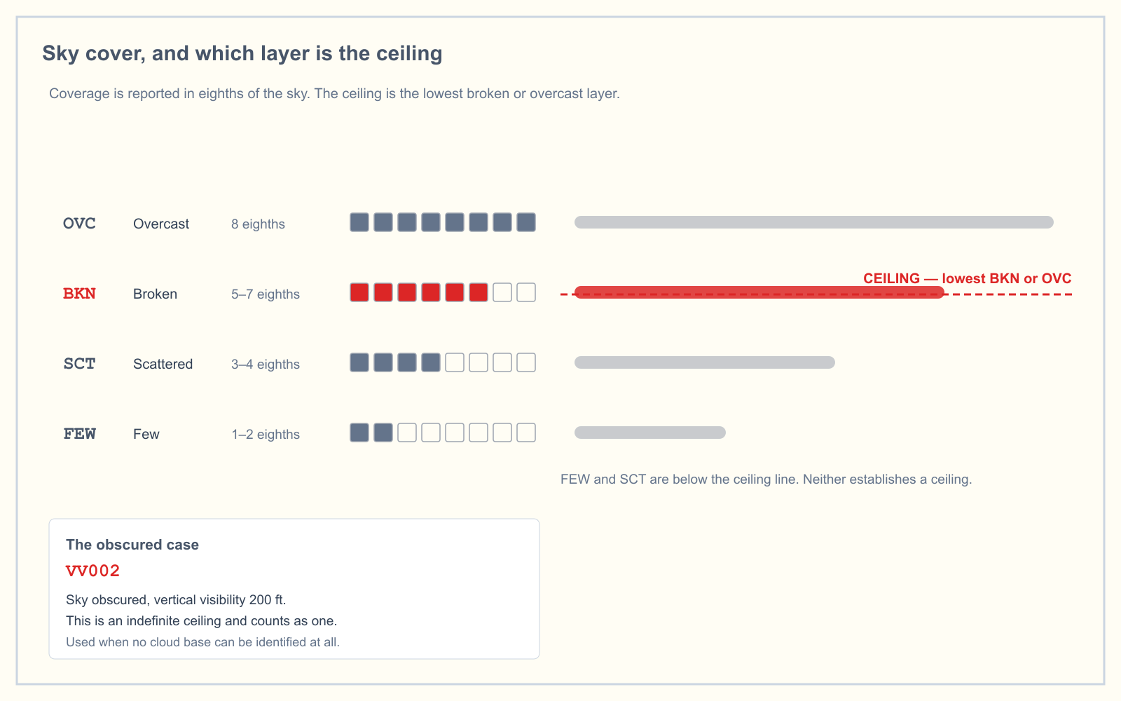
Heights are in hundreds of feet above ground level at the airport. OVC008 is 800 feet, not 8,000. The ceiling is the lowest broken or overcast layer, or the vertical visibility into an obscuration, which is why a scattered layer at 500 feet leaves the field technically ceiling-free.
The change groups, where the exam question hides
Three groups subdivide the forecast, and they do not behave the same way.
| Group | What it means | How long |
|---|---|---|
FM | A permanent change, over less than an hour. Everything after it replaces the previous conditions until the next change group | To the end of the period, or the next FM |
TEMPO | Temporary fluctuations, each lasting under an hour and together covering under half the window | No more than 4 hours |
PROB30 | A 30 percent chance of a thunderstorm or precipitation event and the conditions that come with it | No more than 6 hours |
The distinction that costs people the question is between FM and TEMPO. An FM group is a clean handover. The old conditions are gone. A TEMPO group is an interruption laid over whatever the prevailing forecast already said, and when it ends you revert to the prevailing line, which is still in force underneath.
In the example, FM121800 establishes overcast at 800 feet with 5 miles of visibility. The TEMPO 1220/1224 line does not cancel that. It says that between 2000Z and 2400Z there may be periods, each under an hour, of thunderstorm conditions with 2 miles of visibility. Outside those bursts, you are back to 5 miles and overcast 800.
One more thing worth knowing, because most study material gets it wrong. BECMG does not appear in US National Weather Service TAFs. Appendix E of NWS Instruction 10-813 lists it explicitly as international terminology not used, alongside CAVOK and NSC. You may still meet BECMG on a test question drawn from ICAO material or on a foreign or military forecast, where it signals a gradual change over the stated window. Just do not go looking for it in a KGGG forecast. For the same reason, PROB30 is the only probability group the NWS uses. PROB40 exists internationally but not here.
Working a TAF against 14 CFR 107.51
This is the part that turns decoding into a go or no-go decision. Under 14 CFR 107.51 you need 3 statute miles of flight visibility from the control station, and the aircraft must stay 500 feet below and 2,000 feet horizontally from any cloud.
Take the 1800Z block: 5SM BR OVC008.
Visibility of 5 statute miles clears the 3-mile requirement. The overcast layer at 800 feet does not clear so easily. You need 500 feet of separation below it, which caps you at 300 feet AGL. The 400-foot ceiling in 107.51(b) is no longer your limiting factor; the cloud is.
Now the TEMPO window. Forecast visibility drops to 2 statute miles, which is below the minimum outright. During those bursts there is no legal altitude, because the visibility requirement fails before the cloud clearance is even relevant. You are grounded twice over.
That is the shape of nearly every exam question on this: convert the cloud height, subtract 500, and check the visibility separately. Our VFR weather minimums guide works through why the Part 107 figures are fixed while the Part 91 table changes with airspace.
What a TAF does not tell you
The forecast is a planning document. It is not a substitute for the assessment 14 CFR 107.49 requires you to make before every flight, and there are four gaps a working remote pilot should hold in mind.
It is not your launch site. Five statute miles is a small circle, and most jobs are outside it. A coastal airport reporting P6SM tells you very little about the valley eight miles inland holding fog until noon.
The heights are above the airport, not above you. Cloud bases are given as AGL relative to airport elevation. Launch from a ridge 400 feet higher and that 800-foot overcast is 400 feet above your own ground.
It is not the legal visibility figure. Section 107.51(c) defines flight visibility as the average slant distance from the control station at which prominent unlighted objects can be seen and identified. You determine that where you stand. The TAF cannot do it for you, and neither can a METAR from a field down the road.
It is a forecast, and forecasts are amended. A TAF AMD supersedes the earlier one entirely. Pulling a TAF the night before and not refreshing it in the morning is how people get surprised.
How the exam asks it
Weather sits in the Weather area of the Airman Certification Standards, which is 5 percent of the Unmanned Aircraft General knowledge test under the blueprint effective 29 September 2025. It is a small slice, but TAF and METAR questions are close to guaranteed within it, and they take three shapes:
- Straight decoding. You are given a group and asked what it means.
OVC008is overcast at 800 feet AGL. - Find the right block. A TAF plus a specific time, and you have to pick the block in force then. Check whether a
TEMPOoverlaps before answering from theFMline. - Legality. A TAF plus a proposed altitude, and you decide whether the flight complies with 107.51. Subtract in the right direction.
You can drill the decoding half in the METAR practice trainer, which uses real report formats rather than tidied summaries.
Frequently asked questions
What is the difference between a METAR and a TAF?
A METAR is an observation of conditions measured at a station at a particular moment. A TAF is a forecast of expected conditions within 5 statute miles of the center of an airport's runway complex, normally covering the next 24 hours. Both use the same wind, visibility, weather and sky cover codes.
How long is a TAF valid?
Most TAFs are valid for 24 hours from the start of the period. A set of FAA-specified international airports issue 30-hour forecasts instead. Scheduled TAFs are issued four times daily, at 0000, 0600, 1200 and 1800 UTC, and a newly issued forecast cancels the previous one for that location.
What does TEMPO mean in a TAF?
TEMPO marks temporary fluctuations expected to last under an hour in each instance and, in aggregate, less than half the stated window. A TEMPO group covers no more than four hours. It overlays the prevailing forecast rather than replacing it, so conditions revert when the group ends.
What is the difference between FM and TEMPO?
FM is a permanent handover. Everything following it replaces the previous conditions until the next change group. TEMPO is a temporary interruption sitting on top of the prevailing forecast, which remains in force underneath and resumes once the TEMPO window closes. Confusing the two is the most common TAF error.
Does P6SM mean unlimited visibility?
No. P6SM means the forecast visibility is greater than 6 statute miles, which is the highest value a US TAF encodes. A day with 7 miles and a day with 40 miles are both written P6SM, so the group tells you the visibility is not a limiting factor rather than how good it actually is.
Can I use a TAF to satisfy the Part 107 visibility requirement?
No. Section 107.51(c) requires 3 statute miles of flight visibility as assessed from your control station, which is a judgment you make at the site. A TAF is a forecast for a circle around an airport and is a planning tool for deciding whether to travel, not the legal determination on the day.
Ready to see whether this holds up under exam conditions? The free readiness assessment mixes weather questions in with the other four knowledge areas, so you find out where you actually stand.
Sources
- 14 CFR 107.51 — Operating limitations for small unmanned aircraft
- 14 CFR 107.49 — Preflight familiarization, inspection, and actions for aircraft operation
- 14 CFR 1.1 — General definitions, including ceiling
- NWS Instruction 10-813, Terminal Aerodrome Forecasts (30 October 2024)
- Aviation Weather Center — TAF products
- FAA Airman Certification Standards
Put this guide into practice.
Take the free assessment to see how this topic fits into your current exam readiness.
Start free practice