Weather
How to Read a METAR, Group by Group
A METAR is not a paragraph, it is eight fixed slots in a fixed order. Learn the order and the report reads itself.
Key takeaway
Read a METAR strictly left to right and never guess a group from context. The lowest broken or overcast layer is the ceiling, and that single number answers most weather questions on the exam.
A METAR is not a paragraph. It is a fixed sequence of slots, always in the same order, and once you know the order the report reads itself. Every METAR gives you the station, the time, the wind, the visibility, the weather, the sky condition, the temperature and dew point, the altimeter setting, and then any remarks — in exactly that sequence.
Here is a full report with every group labeled. Nothing below this figure is new information; the rest of the article just explains each slot in turn.
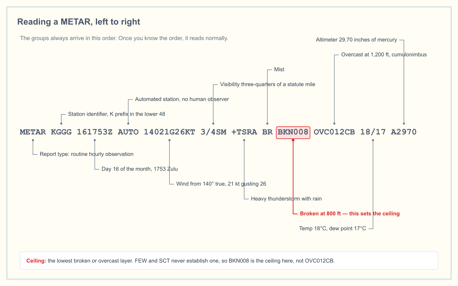
Read it left to right and never skip ahead
The single most useful habit is refusing to jump to the group you care about. Candidates who scan for the cloud layer and stop end up misreading BKN008 as 8,000 feet, or reading a TEMPO line from a TAF as though it were current conditions. Work through the slots in order, out loud if it helps, and the ambiguity disappears.
Take the report in the figure:
METAR KGGG 161753Z AUTO 14021G26KT 3/4SM +TSRA BR BKN008 OVC012CB 18/17 A2970
| Group | Meaning |
|---|---|
METAR | Routine hourly observation. A SPECI here would mean a special report issued because something changed significantly |
KGGG | Station identifier. In the lower 48 states these start with K |
161753Z | The 16th day of the month, 1753 Zulu (UTC). Never local time |
AUTO | Fully automated station with no human observer. COR would mean a corrected report |
14021G26KT | Wind from 140 degrees true, 21 knots, gusting 26 |
3/4SM | Three-quarters of a statute mile visibility |
+TSRA BR | Heavy thunderstorm with rain, and mist |
BKN008 OVC012CB | Broken at 800 feet, overcast at 1,200 feet with cumulonimbus |
18/17 | Temperature 18 °C, dew point 17 °C |
A2970 | Altimeter 29.70 inches of mercury |
That report describes a thunderstorm sitting on the field with three-quarters of a mile of visibility. No drone flight is legal in it, and the reason is in the sixth slot, not the ninth.
The four groups that cause the most trouble
Wind direction is true, not magnetic
A METAR reports wind direction referenced to true north. The tower, when it reads you the wind over the radio, gives it referenced to magnetic north. Runway numbers are magnetic too. This is a real trap in exam questions that pair a METAR with a runway and ask which end is favored — the answer depends on applying magnetic variation, which the sectional gives you as an isogonic line.
Wind of 00000KT is calm. VRB in place of the three digits means the direction is variable, which automated stations report when the wind is 6 knots or less and shifting.
Visibility is in statute miles, and it is a whole number or a fraction
10SM is ten statute miles, which is the maximum an automated station reports. 1/2SM is half a mile. 1 1/2SM — with a space — is a mile and a half. Part 107 requires 3 statute miles of flight visibility from your control station, so any figure below 3SM in the report is a strong signal, though not a legal determination: the regulation asks what you can see from where you are standing, not what the station reported.
Cloud heights are in hundreds of feet above the station
Three digits, multiply by 100. BKN008 is 800 feet. OVC250 is 25,000 feet. And critically, that height is above ground level at the reporting station, not above sea level — which is why you can compare it directly to your own AGL altitude without converting anything, provided you are near that station.
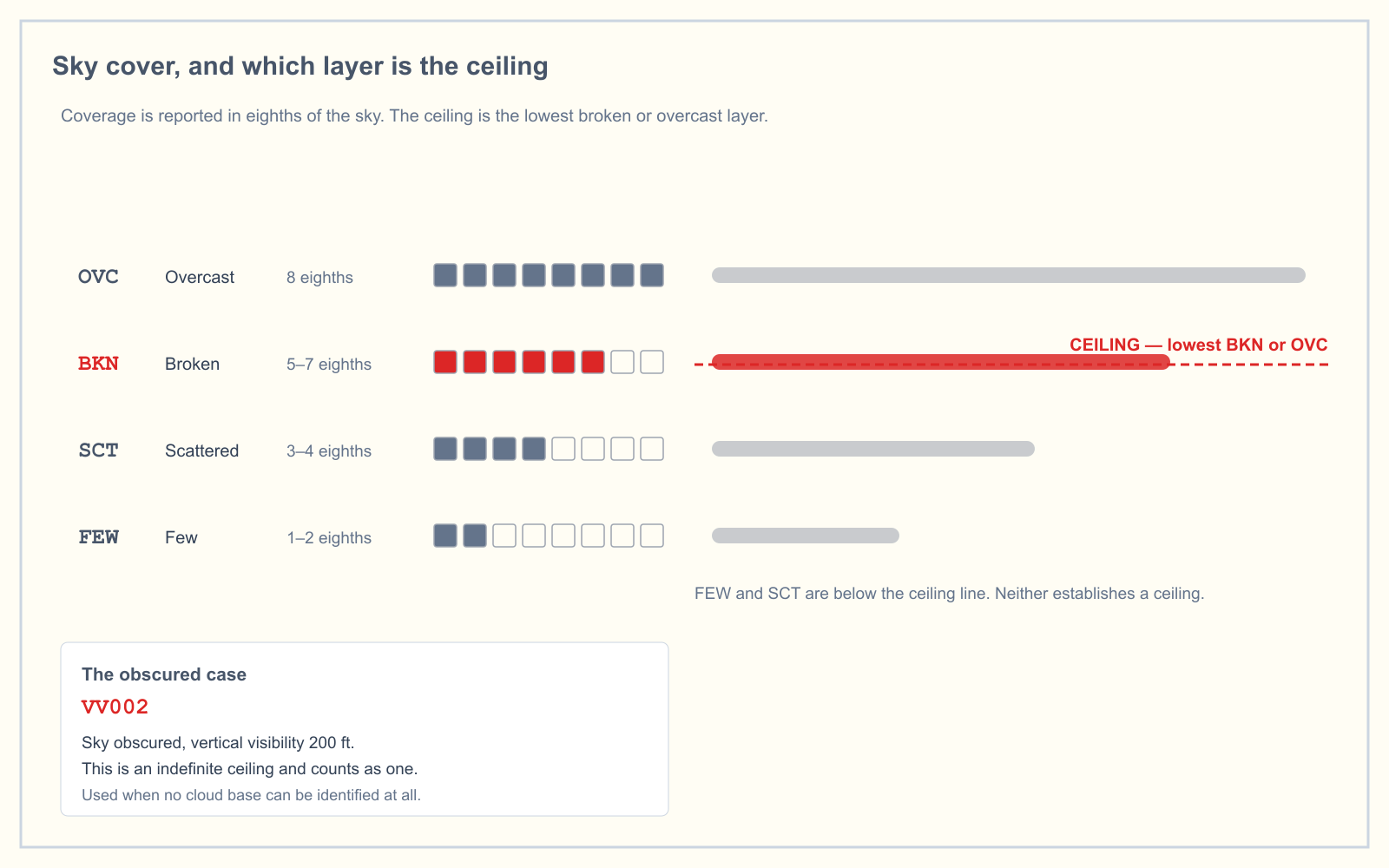
The coverage codes describe how much of the sky is covered, in eighths:
| Code | Coverage | Is it a ceiling? |
|---|---|---|
SKC / CLR | None reported | No |
FEW | 1 to 2 eighths | No |
SCT | 3 to 4 eighths | No |
BKN | 5 to 7 eighths | Yes |
OVC | 8 eighths | Yes |
VV | Sky obscured; the figure is vertical visibility | Yes |
The ceiling is the lowest broken or overcast layer
This is the number most weather questions on the knowledge test are actually asking about. Few and scattered layers are not ceilings, no matter how low they are. The ceiling is the height of the lowest BKN or OVC layer, or the vertical visibility if the sky is obscured.
In FEW020 SCT045 BKN070, the ceiling is 7,000 feet. The two lower layers are irrelevant to that determination, even though they are the ones you would fly through first.
Present weather: intensity, descriptor, phenomenon
The weather group is built from parts in a fixed order, which is why +TSRA decodes cleanly even if you have never seen that exact combination.
- Intensity comes first:
-is light, no symbol is moderate,+is heavy. - A descriptor may follow:
TSthunderstorm,SHshowers,FZfreezing,BLblowing,DRdrifting,MIshallow,BCpatches,PRpartial. - The phenomenon comes last:
RArain,SNsnow,DZdrizzle,GRhail,GSsmall hail,FGfog,BRmist,HZhaze,FUsmoke,DUdust,SQsquall,FCfunnel cloud.
So -SHRA is light rain showers, FZDZ is freezing drizzle, and VCTS — with the VC prefix — is a thunderstorm in the vicinity, meaning between 5 and 10 statute miles from the field rather than over it.
VCTS deserves attention. A thunderstorm 8 miles away is not on the field and will not stop an automated station reporting good visibility, but the standard avoidance distance for a thunderstorm is 20 nautical miles. The report can look flyable while the sky is not.
Temperature, dew point, and the spread that matters
Both figures are in whole degrees Celsius, with M marking a negative value. M02/M04 is minus 2 over minus 4.
The gap between them — the spread — tells you how close the air is to saturation. In the sample report above, 18 over 17 is a one-degree spread, which is fog or low cloud territory. A narrowing spread through the evening is the classic setup for radiation fog forming overnight, and a spread of 2 °C or less with light wind and clear skies is when to expect it.
The altimeter setting
A2970 is 29.70 inches of mercury. The decimal is always implied between the second and third digits. Standard sea-level pressure is 29.92, so this station is reporting lower than standard — the air is less dense than standard, which nudges density altitude up.
Remarks
Everything after RMK is supplementary. Automated stations produce a lot of it and most of it does not matter for a Part 107 decision, but three items are worth recognizing:
AO1andAO2describe the station's sensor package;AO2can distinguish precipitation type,AO1cannot.SLPgives sea-level pressure in a coded form.PK WNDrecords a peak wind since the last report, which is often higher than the wind in the main body.
Frequently asked questions
How do you read a METAR?
Read it strictly left to right through fixed slots: report type, station identifier, date and time in Zulu, any modifier such as AUTO, wind, visibility, present weather, sky condition, temperature and dew point, altimeter setting, and remarks. Each slot always appears in that order, so the position of a group tells you what it is.
What is the ceiling in a METAR?
The ceiling is the height of the lowest broken (BKN) or overcast (OVC) layer, or the vertical visibility (VV) when the sky is obscured. Few and scattered layers never establish a ceiling regardless of how low they are.
Are METAR cloud heights AGL or MSL?
Cloud heights in a METAR are given in hundreds of feet above ground level at the reporting station. BKN008 means a broken layer at 800 feet AGL, not 800 feet MSL.
Is METAR wind direction true or magnetic?
METAR wind direction is referenced to true north. Wind read to you over the radio by a tower or ATIS is referenced to magnetic north, which is why the two can differ by the local magnetic variation.
What does AUTO mean in a METAR?
AUTO indicates the observation came from a fully automated station with no human observer present. A COR modifier in the same position means the report is a correction to a previous one.
What is the difference between a METAR and a TAF?
A METAR is an observation of conditions that exist now at a specific station. A TAF is a forecast covering a period ahead — typically 24 or 30 hours — within roughly 5 statute miles of the airport. Reading a TAF line as though it were current conditions is one of the most common mistakes on the knowledge test.
Reading about the format and decoding one under time pressure are different skills. The METAR practice trainer gives you real coded reports and asks the questions the exam asks, so you find out which groups you actually have.
Sources
Put this guide into practice.
Take the free assessment to see how this topic fits into your current exam readiness.
Start free practice