Weather
Air Masses: The Types, How They Form, and What Each One Does to a Flight
An air mass is a huge body of air with the temperature and moisture of the place it came from. The FAA recognizes five types, and the one over you decides whether the day is hazy and smooth or clear and bumpy.
Key takeaway
An air mass is named for where it formed, but it behaves according to the surface it is crossing now: warmed from below it turns unstable (clear and bumpy), cooled from below it turns stable (hazy, low cloud, fog).
An air mass is a large body of air with generally uniform temperature and humidity, picked up from the region where it formed. The FAA classifies air masses by two letters: c (continental, dry) or m (maritime, moist), then A (arctic), P (polar) or T (tropical). That gives five types: cA, cP, cT, mP and mT.
Most explanations stop at the list, which is the least useful part. The name tells you where the air came from. What decides your flight is what the air is doing now: whether the ground under it is warmer or colder than the air. That one comparison predicts whether you get a hazy, smooth, low-ceiling day or a clear, gusty, bumpy one. It is also the bit the knowledge test actually asks about.
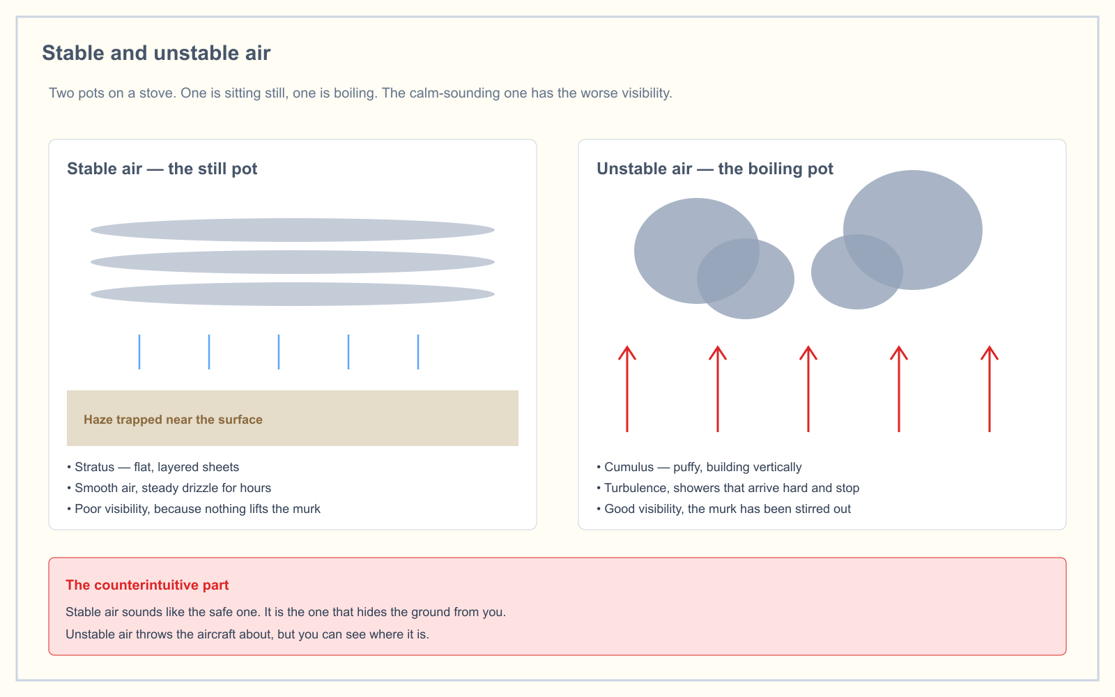
What is an air mass?
The FAA's Aviation Weather Handbook defines an air mass as a large body of air with generally uniform temperature and humidity. The area where it forms is its source region.
A source region has to hold air still for days or longer. While the air sits there it takes on the surface's temperature and moisture. The Pilot's Handbook of Aeronautical Knowledge names the typical ones: polar regions, tropical oceans and dry deserts. Snowfields make cold air, warm seas make warm and moist air, and deserts make hot and dry air.
One detail catches people out. The Aviation Weather Handbook notes that the United States is not a favorable source region. Weather systems cross the country too often for air to stagnate. That makes the US a place where air masses arrive and meet, which is why the country gets so many fronts.
How are air masses classified?
Each air mass gets two letters. The lowercase letter says how much moisture it has, which depends on whether it formed over land or water. The uppercase letter says how warm it is, which depends on latitude.
| Letter | Stands for | What it tells you |
|---|---|---|
| c | Continental | Dry, formed over land |
| m | Maritime | Moist, formed over water |
| A | Arctic | Extremely deep and cold, forms mostly in winter over ice and snow |
| P | Polar | Relatively shallow, cool to cold, forms over high latitudes |
| T | Tropical | Warm to hot, forms over low latitudes |
Put them together and you get the air mass's name. The moisture letter always comes first: mT is maritime tropical, never "Tm".
What are the five types of air masses?
The Aviation Weather Handbook lists five. People searching "four types of air masses" are usually working from a school textbook that leaves out continental arctic. The FAA does not leave it out.
| Air mass | Code | Temperature and moisture | Typical source | What it tends to bring |
|---|---|---|---|---|
| Continental arctic | cA | Cold, dry | Arctic ice and snow in winter | Bitter cold, very dry air, often clear skies |
| Continental polar | cP | Cold, dry | Canada and other high-latitude land | Cool or cold, dry, clear |
| Continental tropical | cT | Hot, dry | Deserts; the Mexican Plateau for the US | Heat, low humidity, dust and haze |
| Maritime polar | mP | Cool, moist | High-latitude oceans | Cool, damp, low cloud and showers |
| Maritime tropical | mT | Warm, moist | Warm tropical waters such as the Caribbean and Gulf | Humidity, thunderstorms, fog where it cools |
The handbook explains why maritime arctic is missing: it seldom, if ever, forms. Air over the Arctic Ocean sits on ice, not open water, so it never picks up much moisture.
The PHAK uses a shorter version that covers most exam questions. Continental polar air brings cool, dry air. Maritime tropical air forms over warm tropical waters like the Caribbean and brings warm, moist air.
How are air masses modified as they move?
Air masses do not stay put. Once one leaves its source region, the ground or water beneath it starts changing it. The handbook gives three examples:
- Arctic air over the ocean. In winter, very cold, dry arctic air that moves out over warmer ocean picks up heat and moisture. It becomes maritime polar: still fairly cold, but now moist.
- Polar air heading south. The same polar air moving south from Canada over land warms up but stays dry, because there is no water to supply moisture. It remains continental polar.
- Tropical air heading north. In summer, continental tropical air is pushed north off the Mexican Plateau. If it stalls over the Midwest, the handbook says a drought can follow. Maritime tropical air comes north from the tropics over the Gulf and the Atlantic and gives the Gulf Coast and eastern states their humid summers.
The Great Lakes show modification happening quickly. In autumn and winter, cold, dry, stable polar air crossing the relatively warm lakes is heated and moistened from below. It becomes less stable and builds bands of cumulus and showers downwind. That is lake effect weather, including lake effect snow.
Why does the surface under an air mass matter so much?
This is the part that affects your flight, and the PHAK describes it clearly:
- An air mass passing over a warmer surface is warmed from below. Convective currents form and the air turns unstable. You get good surface visibility, and if the air is moist, cumulus clouds, showers and turbulence.
- An air mass passing over a colder surface gets no convective currents and becomes stable. Smoke, dust and haze cannot rise out of it, so surface visibility is poor. A stable air mass can produce low stratus and fog.
| Air mass is moving over... | Stability | Clouds | Visibility | Air near the ground |
|---|---|---|---|---|
| A warmer surface | Unstable | Cumuliform, building vertically | Good | Gusty and turbulent |
| A colder surface | Stable | Stratiform, low stratus | Poor: haze, smoke, fog | Smooth |
That explains why one air mass can bring both kinds of weather. Maritime tropical air spreading over hot land on a summer afternoon is warmed from below and grows into thunderstorms. The same mT air flowing over cold coastal water or a winter landscape is cooled from below and turns into advection fog and drizzle. The label stays the same while the weather flips.
For the physics behind this, see stable vs unstable air and the adiabatic lapse rate, which explain why a parcel warmed from below keeps rising.
What happens when two air masses meet?
They do not mix quickly. The Aviation Weather Handbook says air masses can control the weather for days to months, and most weather occurs along their edges. The boundary between two air masses is a front.
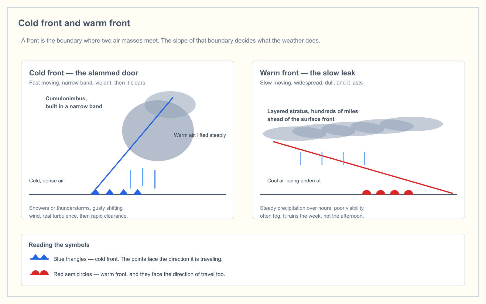
The colder, denser air stays at the surface, and the warmer air is lifted up and over it. Fronts are named for which air mass is advancing: warm, cold, stationary or occluded. The PHAK puts the practical point plainly: an approaching front of any type means the weather is about to change.
Air masses tell you what the weather will be like for the next few days. Fronts tell you when it will change. The full breakdown of each front is in the four types of weather fronts.
What this means when you are actually working
Part 107 does not mention air masses. It sets fixed limits, and the air mass decides which of them you will run into. Under 14 CFR 107.51 you need at least 3 statute miles of flight visibility, and you must stay 500 feet below and 2,000 feet horizontally from clouds.
Each air mass tends to threaten those limits in a different way:
- Stable, moist air (mT or mP cooled from below). Visibility and ceiling are the problem. The haze that does not bother you on a job at noon can drop visibility below 3 miles at dawn, and stratus can settle low enough that 400 feet no longer fits under the 500-foot clearance. Expect smooth air and a grounded aircraft.
- Unstable, moist air (mT warmed from below). Wind is the problem. Visibility is excellent until the afternoon thunderstorms arrive with gust fronts and microbursts that can reach you before the rain does. Plan shoots for the morning.
- Cold, dry air (cP or cA). Usually the clearest flying of the year, often behind a cold front. The limit is the battery: lithium cells lose capacity in the cold, so short flights and warm spare packs matter more than the forecast.
- Hot, dry air (cT). Visibility is fine unless there is dust. Thin, hot air reduces performance, which is the density altitude problem, and thermals make the air bumpy.
In practice: check which air mass is overhead and what surface it is crossing today. That tells you which part of the METAR and TAF to read first.
How the exam asks about air masses
Weather is 5% of the current Part 107 knowledge test, so you will see only a few weather questions. Air mass questions almost always test stability rather than the naming scheme:
- "What are characteristics of a moist, unstable air mass?" Cumuliform clouds, showery precipitation, turbulence, good visibility.
- "What are characteristics of stable air?" Stratiform clouds, fog, continuous precipitation, smooth air, poor visibility.
- "An air mass moving over a colder surface becomes..." More stable.
If you can say what the surface is doing to the air, you can answer all three.
Frequently asked questions
What are the five types of air masses?
The FAA's Aviation Weather Handbook lists continental arctic (cA, cold and dry), continental polar (cP, cold and dry), continental tropical (cT, hot and dry), maritime polar (mP, cool and moist) and maritime tropical (mT, warm and moist). Maritime arctic is left out because it seldom, if ever, forms over the ice-covered Arctic Ocean.
What is an air mass and its types?
An air mass is a large body of air with generally uniform temperature and humidity, taken on from its source region. Types are named by moisture, continental (dry) or maritime (moist), and by temperature: arctic, polar or tropical. Combining them gives cA, cP, cT, mP and mT.
What are the four types of air masses?
School textbooks usually list four: continental polar, continental tropical, maritime polar and maritime tropical. The FAA adds a fifth, continental arctic, which is an extremely deep, cold air mass that forms mostly in winter over arctic ice and snow. For the Part 107 exam, the stability behavior of the air matters more than the count.
How are air masses classified?
Air masses are classified by the temperature and moisture of their source region. A lowercase letter gives moisture: c for continental (dry, formed over land) or m for maritime (moist, formed over water). An uppercase letter gives temperature: A for arctic, P for polar or T for tropical. The moisture letter always comes first.
What happens when two air masses meet?
They form a front, which is a boundary or transition zone between them. The colder, denser air stays near the surface and the warmer air is lifted over it. That lifting produces most of the significant weather. Fronts are named cold, warm, stationary or occluded depending on which air mass is advancing.
Why is stable air hazy and unstable air clear?
Stable air suppresses vertical movement, so smoke, dust and moisture near the ground cannot rise and disperse, which reduces visibility. Unstable air carries those particles upward through a deep layer, which leaves the surface clear. According to the PHAK, an air mass becomes stable over a colder surface and unstable over a warmer one.
Air masses, stability and fronts are tested together. The free readiness assessment mixes them in with the other four knowledge areas so you can see where your weak spots are.
Sources
Put this guide into practice.
Take the free assessment to see how this topic fits into your current exam readiness.
Start free practice