Weather
Stable vs Unstable Air: Why the Calm Day Has the Worse Visibility
Two pots on a stove: one sitting still, one boiling. The one sitting still is the one you cannot see through.
Key takeaway
Stable air produces layered stratus, smooth flight and poor visibility. Unstable air produces building cumulus, turbulence and good visibility. The smooth day is the one that hides the ground.
Atmospheric stability describes what a parcel of air does after something lifts it. In stable air the parcel sinks back to where it started, so vertical motion is suppressed. In unstable air the parcel keeps rising on its own, so vertical motion continues. That single difference decides the cloud type, the turbulence and the visibility you will meet.
The result is counterintuitive, and it catches people out on the knowledge test: stable air is the smooth, calm-looking one, and it is also the one that hides the ground from you.
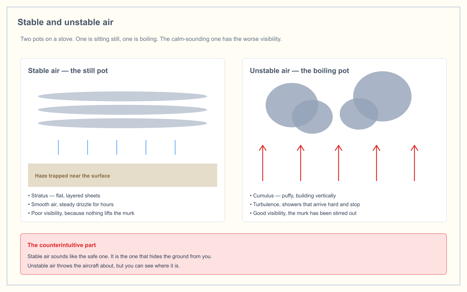
The comparison in one table
| Stable air | Unstable air | |
|---|---|---|
| A lifted parcel | Returns to its original level | Keeps rising |
| Cloud form | Stratiform — flat, layered sheets | Cumuliform — puffy, building vertically |
| Precipitation | Steady, light, prolonged drizzle or rain | Showery — heavy, brief, intermittent |
| Turbulence | Smooth | Rough, sometimes severe |
| Visibility | Poor — haze and smoke trapped near the surface | Good — pollutants mixed and carried away |
| Wind | Steady | Gusty, shifting |
| Typical hazard | Fog, low ceilings, icing in layers | Thunderstorms, wind shear, hail |
Why it works this way
Air cools as it rises, because it expands into lower pressure. That much is fixed. The question is whether it cools faster or slower than the air around it.
A rising parcel of dry air cools at roughly 3 °C per 1,000 feet — the dry adiabatic lapse rate. The surrounding atmosphere has its own actual, or ambient, lapse rate, which varies with the day.
- If the surrounding air cools slowly with height, the rising parcel quickly becomes colder and denser than its surroundings, so it sinks back. That is stable.
- If the surrounding air cools rapidly with height, the rising parcel stays warmer and lighter than its surroundings, so it keeps going. That is unstable.
The standard atmosphere cools at about 2 °C per 1,000 feet, which is slower than the parcel's 3 °C, so the standard atmosphere is mildly stable. Real days deviate constantly.
Once condensation begins, a rising parcel releases latent heat and cools more slowly — around 1.2 to 1.5 °C per 1,000 feet, the moist adiabatic lapse rate. This is why a moist air mass can be far more unstable than a dry one with the same temperature profile, and it is the engine behind a thunderstorm.
The temperature inversion: stability taken to its extreme
An inversion is a layer where temperature increases with height instead of decreasing. Nothing rising through it will keep rising, because it immediately finds air warmer and lighter than itself. An inversion is a lid.
The most common kind forms overnight. The ground radiates heat away under a clear sky, chilling the air immediately above it while the air a few hundred feet up stays warmer. By dawn there is a shallow, extremely stable layer sitting on the surface.
That layer traps everything emitted into it — smoke, dust, industrial haze, moisture — which is exactly why the calmest, smoothest morning of the week can also be the one with quarter-mile visibility. If the air cools to its dew point, that trapped moisture becomes radiation fog.
For a remote pilot, an inversion morning has a specific signature: perfectly smooth air, no wind at the surface, and visibility that fails the 3-statute-mile requirement in 14 CFR 107.51. There is also a wind shear risk at the top of the inversion, where calm surface air meets a much stronger flow a few hundred feet up — which for a small drone climbing through it can mean an abrupt change in groundspeed and attitude.
Reading stability from what you can see
You rarely have a temperature sounding. What you do have is the sky.
Signs of stable air
- Flat, layered cloud with a defined horizontal base
- Smooth flight with no bumps
- Haze layer with a sharp top, visible from above
- Steady drizzle rather than showers
- Fog or mist in a METAR, especially
BRorFG - Poor visibility that does not improve through the morning
Signs of unstable air
- Cumulus with visible vertical development
- Bumpy air, especially over dark surfaces in the afternoon
- Showers that arrive hard and stop
- Excellent visibility — you can see the terrain 30 miles out
- Gusty, shifting surface wind
- Towering cumulus building through the day
Which one is more dangerous?
Both, differently, and that is the point.
Unstable air is the obvious hazard. It produces the turbulence, the wind shear and, at the extreme, the thunderstorm. A small multirotor has very little margin against a strong gust, and gusts in unstable air are both stronger and less predictable.
Stable air is the quieter hazard. It produces the conditions that end a flight legally rather than physically: visibility below 3 statute miles, ceilings that leave no room under 14 CFR 107.51's cloud-clearance requirement, and fog that forms faster than a crew expects. It is also the condition most likely to make a crew feel safe while flying illegally, because nothing about it feels wrong.
How it appears on the knowledge test
Stability sits in the Weather and Loading area of the Airman Certification Standards, worth 5 percent of the exam. The questions almost always take one of three shapes:
- Matching a condition to an air mass. "What are the characteristics of stable air?" Look for the stratiform/smooth/poor-visibility cluster.
- Predicting from a temperature and dew point spread. A small spread with a stable layer means fog or low stratus is likely.
- Reasoning from the lapse rate. A steeper-than-standard ambient lapse rate means unstable, which means cumuliform cloud and turbulence.
Frequently asked questions
What is the difference between stable and unstable air?
In stable air a lifted parcel returns to its original level, so vertical motion is suppressed and clouds form in flat layers. In unstable air a lifted parcel keeps rising on its own, so vertical motion continues and clouds build vertically. Stable air is smooth with poor visibility; unstable air is turbulent with good visibility.
Why does stable air have poor visibility?
Stable air suppresses vertical mixing, so smoke, dust, haze and moisture emitted near the surface stay near the surface instead of being carried upward and dispersed. Unstable air stirs those pollutants through a deep layer, which is why turbulent days are usually clear days.
What clouds form in stable air?
Stable air produces stratiform clouds — stratus, nimbostratus and altostratus — which are flat, layered and horizontally extensive. Precipitation from them is steady and prolonged rather than showery.
What is a temperature inversion?
A temperature inversion is a layer in which temperature increases with height rather than decreasing. It is an extremely stable layer that acts as a lid, trapping haze and moisture beneath it, and it commonly forms overnight under clear skies with light wind.
What is the dry adiabatic lapse rate?
The dry adiabatic lapse rate is the rate at which an unsaturated parcel of air cools as it rises, approximately 3 °C per 1,000 feet. Comparing it to the actual lapse rate of the surrounding air is how atmospheric stability is determined.
Is unstable air more dangerous than stable air?
Unstable air carries the more dramatic hazards — turbulence, wind shear and thunderstorms. Stable air carries the more common ones for a remote pilot: visibility below the 3 statute miles required by 14 CFR 107.51, low ceilings, and fog. Stable air is more likely to end a flight legally; unstable air is more likely to end one physically.
Stability, fronts and thunderstorms are all one topic on the exam and are tested together. The free readiness assessment mixes them in with the other four knowledge areas so you can see where the weakness actually is.
Sources
Put this guide into practice.
Take the free assessment to see how this topic fits into your current exam readiness.
Start free practice