Weather
The Four Types of Weather Fronts, and What Each One Does to a Flight
Fronts are not weather. They are boundaries, and the angle of the boundary tells you whether you get an afternoon of thunderstorms or a week of drizzle.
Key takeaway
A cold front has a steep boundary that lifts warm air fast, producing violent, short-lived weather. A warm front has a shallow boundary, producing mild, widespread weather that lasts for days.
A front is not weather. It is a boundary between two air masses with different temperature and moisture, and the weather comes from what happens when one is forced to rise over the other. There are four types — cold, warm, stationary and occluded — and the difference between them is almost entirely the slope of that boundary and which air mass is doing the pushing.
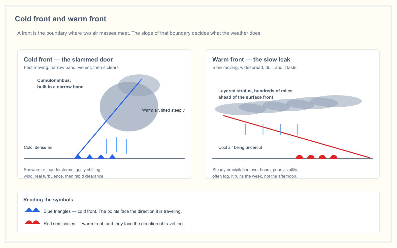
Get the slope right and everything else follows. A steep boundary lifts air fast, which builds tall clouds and violent, short-lived weather. A shallow boundary lifts air slowly over hundreds of miles, which builds flat clouds and dull weather that lasts for days.
The four types
| Front | What is happening | Cloud type | Weather | Duration |
|---|---|---|---|---|
| Cold | Cold air advances and undercuts warm air, lifting it steeply | Cumulus, cumulonimbus | Showers, thunderstorms, gusty shifting wind, turbulence | Hours |
| Warm | Warm air advances and rides up over retreating cold air | Cirrus, then stratus, nimbostratus | Steady precipitation, low visibility, fog | Days |
| Stationary | Neither air mass is winning; the boundary sits still | Mixed, often stratiform | Prolonged, often warm-front-like conditions | Days to a week |
| Occluded | A faster cold front catches a warm front and lifts it clear of the surface | Mixed cumuliform and stratiform | Combination of both, often the widest band of bad weather | A day or two |
The cold front: a slammed door
Cold air is dense, so it stays low and shoves underneath the warm air it meets. The leading edge is blunt — a slope of roughly 1 in 50 to 1 in 100 — and the warm air ahead of it gets thrown upward fast.
Fast lifting builds vertically. That is why cold fronts produce cumulus and, when the air ahead is moist and unstable enough, cumulonimbus with everything a thunderstorm carries: heavy rain, hail, lightning, severe turbulence and wind shear. The band is narrow, often less than 50 miles wide, and it moves quickly — 15 to 25 knots is typical, and some move faster.
For a remote pilot the practical signature is a sudden wind shift, a temperature drop, a rising pressure behind the front, and then unusually clear air. The weather behind a cold front is often the best flying weather of the week.
Squall lines deserve a separate mention. These are lines of thunderstorms that can form 50 to 300 miles ahead of a fast-moving cold front, in the warm sector where nothing on the surface analysis suggests a problem. A squall line frequently contains the most severe weather associated with the whole system, and it will be there before the front arrives.
The warm front: a slow leak
Warm air is less dense, so when it advances it cannot displace the cold air ahead of it. It climbs over the top instead, on a very shallow slope of roughly 1 in 100 to 1 in 300.
Because the slope is so gentle, the cloud deck associated with the front extends enormously far ahead of the surface position. High cirrus can appear 600 to 1,000 miles before the front reaches you, thickening through cirrostratus and altostratus into nimbostratus as it approaches. By the time the surface front arrives you have already had a day or more of deteriorating conditions.
The weather is not dramatic. It is steady light-to-moderate precipitation, poor visibility, low ceilings, and — where rain falls through cold air near the surface — fog. Warm fronts move slowly, typically 10 to 25 knots, and often more slowly than that.
The characteristic remote-pilot problem with a warm front is not turbulence. It is that the ceiling drops below 500 feet above your intended altitude and stays there for three days.
The stationary front
When neither air mass has enough push to displace the other, the boundary stops moving. On a surface analysis chart it is drawn with blue triangles on one side and red semicircles on the other, pointing in opposite directions.
The weather resembles a warm front's — widespread, stratiform, persistent — and the trouble is the persistence. A stationary front parked over a region can hold low ceilings and reduced visibility in place for the better part of a week. It typically ends by dissipating in place, or by starting to move again as one air mass strengthens, at which point it becomes a cold or warm front.
The occluded front
Cold fronts move faster than warm fronts. When a cold front catches the warm front ahead of it, the warm air between them is lifted entirely off the surface. That is an occlusion.
There are two kinds, and which one forms depends on the relative temperature of the two cold air masses:
- Cold occlusion. The advancing air is colder than the air ahead of the warm front, so it undercuts both and lifts them. This is the more common type in the United States.
- Warm occlusion. The advancing air is warmer than the air ahead, so it rides up over it.
Either way you get the cloud and precipitation of both parent fronts arriving together, which is often the widest and most persistent band of bad weather the system produces. An occluded front is drawn in purple, with alternating triangles and semicircles on the same side.
Reading the symbols
The symbols are simple once you know the convention: the points face the direction the front is traveling.
| Symbol | Front |
|---|---|
| Blue triangles | Cold front |
| Red semicircles | Warm front |
| Blue triangles and red semicircles on opposite sides | Stationary front |
| Purple triangles and semicircles on the same side | Occluded front |
What a remote pilot should actually do with this
You are not going to be assigned an IFR route through a frontal system. The reason fronts matter to a Part 107 operation is planning: they tell you what your operating window looks like over the next few days.
- A cold front approaching today means fly this morning or wait until tomorrow. The band is narrow and the weather behind it is usually excellent.
- A warm front approaching means your window is closing and will stay closed. If the job is time-critical, fly before the ceiling drops rather than hoping for a break.
- A stationary front over the area means rescheduling the week, not the afternoon.
- Any front with embedded or pre-frontal thunderstorm activity means the 20-nautical-mile avoidance distance applies, and a squall line ahead of a cold front will not appear where the surface chart puts the boundary.
Frequently asked questions
What are the four types of weather fronts?
The four types are cold fronts, warm fronts, stationary fronts and occluded fronts. They are distinguished by which air mass is advancing and how steeply the boundary between the two air masses is inclined.
What is the difference between a cold front and a warm front?
A cold front has a steep boundary that lifts warm air quickly, producing cumulus and cumulonimbus, showers or thunderstorms, gusty wind and turbulence over a narrow band that passes in hours. A warm front has a shallow boundary that lifts air slowly over hundreds of miles, producing layered stratus clouds, steady precipitation, low visibility and fog that can last for days.
Which type of front produces thunderstorms?
Cold fronts most commonly produce thunderstorms, because their steep boundary lifts warm moist air rapidly enough to build cumulonimbus. Squall lines of severe thunderstorms can also form 50 to 300 miles ahead of a fast-moving cold front, in air that looks clear on a surface analysis.
What is an occluded front?
An occluded front forms when a faster-moving cold front overtakes a warm front and lifts the warm air between them completely off the surface. It combines the cloud and precipitation characteristics of both parent fronts, often producing the widest band of poor weather in the system.
How do you read front symbols on a weather chart?
The points face the direction the front is moving. Blue triangles mark a cold front, red semicircles a warm front, triangles and semicircles on opposite sides a stationary front, and purple symbols alternating on the same side an occluded front.
How fast do weather fronts move?
Cold fronts typically move at 15 to 25 knots and sometimes faster. Warm fronts move more slowly, generally 10 to 25 knots. Stationary fronts, by definition, are moving little or not at all.
Fronts, stability and thunderstorms all appear together in the Weather and Loading portion of the exam. The free readiness assessment shows you which of the five knowledge areas is actually costing you marks.
Sources
Put this guide into practice.
Take the free assessment to see how this topic fits into your current exam readiness.
Start free practice