Weather
The Types of Fog, How Each One Forms, and What It Does to a Flight
Everyone teaches a different number of fog types. The FAA names five formation mechanisms, and the rest are descriptions of what the fog is made of.
Key takeaway
Fog seldom forms when the temperature-dewpoint spread is greater than 4 °F (2 °C). That single number on a METAR tells you more about your morning than the forecast does.
Fog is a cloud whose base sits on the ground, and it reduces visibility to less than 5/8 statute mile. The FAA names five types by how they form: radiation, advection, upslope, frontal and steam. All five require the temperature and dew point to meet, which seldom happens when the spread is greater than 4 °F (2 °C).
Search this topic and you will be told there are three types, or six, or seven. The disagreement is not because anyone is wrong. It is because two different things are being counted: how fog forms, and what fog is made of. Sort those into separate piles and the whole subject collapses into something you can hold in your head at 5 a.m. in a parking lot.
How many types of fog are there?
Five, if you are counting formation mechanisms, which is what the FAA counts. The Aviation Weather Handbook says plainly that fog types are named according to their formation mechanism, and then names radiation, advection, upslope, frontal and steam fog.
Freezing fog and ice fog are also in the handbook, and this is where the counts diverge. Neither describes how fog formed. Freezing fog is any fog made of liquid droplets at or below 32 °F (0 °C). Ice fog is fog made of ice crystals. A bank of radiation fog that cools below freezing becomes freezing fog without changing its formation mechanism at all. It is one fog with two labels.
So the honest answer is five plus two, which is why you see six and seven in the wild. Learn the five. The other two are adjectives.
What has to happen before fog forms?
The temperature and the dew point have to meet. There are only two ways to arrange that, and every type of fog is one or the other:
- Cool the air down to its dew point. This gives you radiation fog, advection fog and upslope fog. The three differ only in what does the cooling.
- Add moisture until the dew point rises to the temperature. This gives you frontal fog and steam fog.
The handbook gives one number that does more work than anything else here: fog seldom forms when the temperature-dew point spread is greater than 2 °C (4 °F). That is a figure you can read straight off a METAR before you leave the house. A spread of 12 over 4 is a comfortable morning. A spread of 6 over 5 at 0400Z, with the temperature still falling, is a job you should expect to lose.
| Type | What causes saturation | Wind that favors it | Where and when |
|---|---|---|---|
| Radiation | Ground cools overnight, cools the air touching it | Calm to about 5 kt | Land only, at night, clearing before noon |
| Advection | Moist air moves over a colder surface | Up to about 15 kt | Coasts and inland, any hour, persistent |
| Upslope | Air cools adiabatically as it climbs terrain | 5 to 15 kt | Sloping ground, notably the eastern Rockies |
| Frontal | Rain falls into cold air and evaporates into it | Any | Under a front, most often a warm front |
| Steam | Water evaporates into very cold air above it | Any | Over lakes and seas, cold mornings |
Radiation fog: the one that takes the dawn job
The ground radiates heat away overnight, the ground cools the air in contact with it, and when that air reaches its dew point you get fog. It needs three things: a shallow moist layer under a dry one, clear skies, and light surface winds.
Wind is the part people get backwards. Calm air gives you shallow fog. Winds up to about 5 knots make it worse, because the mixing spreads the cooling through a deeper layer. Only above that do stronger winds break it up or lift it into a stratus deck. So the still, clear night after a day of rain is the classic setup, and the FAA says as much.
Radiation fog happens over land, because water barely cools overnight. It is shallow, it is a night and early morning event, and ground fog usually burns off fairly quickly after sunrise, with the rest generally clearing before noon unless cloud moves in on top of it.
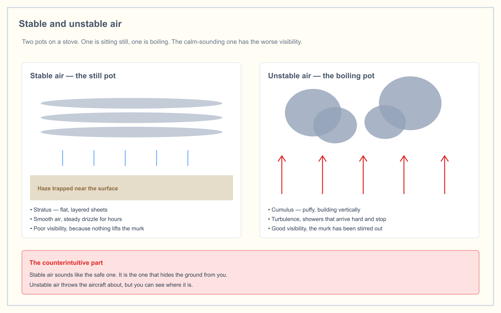
Valleys make it worse. Cool dense air drains downhill overnight and pools at the bottom, so the valley fills from the floor up and the fog is thickest around sunrise. If your launch site is low ground surrounded by higher ground, you are standing in the collection tray. This is stable air doing exactly what stable air does.
Advection fog: the one that arrives while you are flying
Advection fog forms when moist air moves over a colder surface. Nothing about it depends on the time of day, which is the whole problem. It can move in rapidly, day or night, and it is usually more extensive and much more persistent than radiation fog.
The wind behavior is the inverse of radiation fog. Advection fog deepens as the wind increases up to about 15 knots. Above that the wind lifts it into low stratus or stratocumulus. So a freshening breeze is not the reassurance it would be on a radiation fog morning.
Two American versions are worth knowing. The West Coast gets it off cold offshore water, carried inland by the wind, advancing over land at night and retreating in the morning. In winter, moist air off the Gulf spreads north over cold ground across the central and eastern states, sometimes as far as the Great Lakes.
Upslope, frontal and steam fog
Upslope fog forms when moist, stable air is cooled adiabatically as it moves up sloping terrain. Winds of 5 to 15 knots favor it, and unlike radiation fog it can form under a cloudy sky, which removes the one reassuring sign you were relying on. It is common along the eastern slopes of the Rockies, less so east of the Appalachians, and it is often dense and deep.
Frontal fog, also called precipitation-induced fog, is the moisture-adding route. Warm air rides up over a front and rains into the cold air underneath. That rain evaporates into cold air that was already near its dew point, saturates it, and you get a continuous column of water droplets from the ground up into the cloud. It is most commonly associated with warm fronts, it can be dense, and it can shut down operations over a large area for a long time. If you already know what a warm front does to a day, add this to the list.
Steam fog is the reverse arrangement: very cold air moving over relatively warm water. Water evaporates, recondenses immediately in the cold air, and rises in streamers that look like steam off a kettle. Autumn mornings over lakes and rivers are the classic case. Steam fog carries a warning the others do not, because the air producing it is unstable, so expect convective turbulence in it rather than the dead calm you would find in radiation fog.
How fog shows up in a METAR or TAF
The codes are not interchangeable, and the difference between two of them decides whether you fly.
| Code | Meaning | Visibility |
|---|---|---|
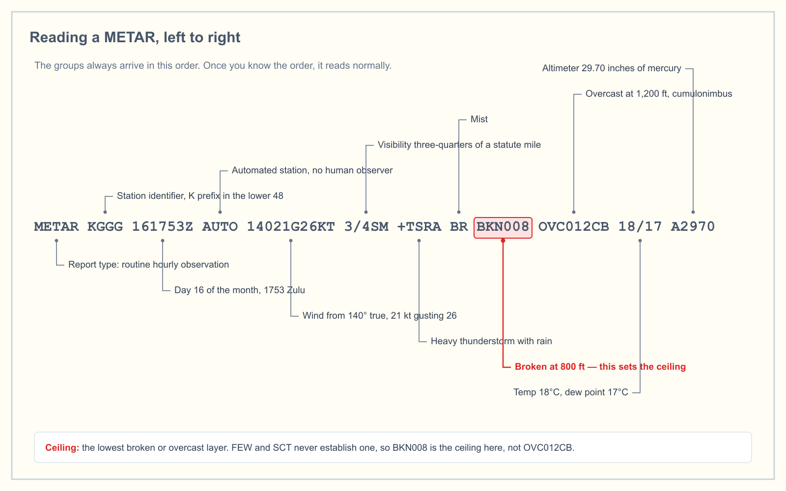
| FG | Fog | Less than 5/8 SM |
| BR | Mist | 5/8 SM to less than 7 SM |
| FZFG | Freezing fog | Reported when temperature is below 0 °C |
| MIFG | Shallow fog | Descriptor, fog only |
| BCFG | Patches of fog | Descriptor, fog only |
| PRFG | Partial fog | Descriptor, fog only |
| VCFG | Fog in the vicinity | 5 to 10 SM from the airport center |
Two details earn their place. The descriptors shallow, partial and patches are only ever coded with fog, so MI, PR and BC in a report mean fog is involved. And the choice between BR and HZ in that 5/8 to 7 mile band is made on the temperature-dew point spread: if the spread is 4 °F (about 2 °C) or less, it is coded as mist, otherwise haze. The report is telling you whether the murk is water or dust, which tells you which way it is about to go. TAF forecasters use the same threshold, so the same reasoning applies when you read a TAF.
What this means when you are the one on the ground
Under 14 CFR 107.51 you need 3 statute miles of flight visibility measured from the control station. Set that against the codes and the decisions make themselves:
- FG is always disqualifying. Fog is defined by visibility under 5/8 statute mile, which is less than a quarter of what Part 107 requires. There is no judgment call in it.
- BR is the one that requires you to look. Mist spans 5/8 to nearly 7 miles, so it straddles the limit. Some misty mornings are legal and some are not, and the reported figure at an airport 12 miles away does not settle it.
- The visibility that counts is yours, not the aircraft's. Section 107.51(c) measures flight visibility from the control station. This matters more with fog than with any other weather, because shallow radiation fog can leave the aircraft in clear sunshine at 300 feet while you stand in 400 yards of visibility on the ground. The aircraft is fine. You are grounded, both on visibility and on the visual line of sight requirement in 107.31.
That last point is the practical difference between fog and every other obstruction you will meet. A ceiling puts something between you and the sky. Fog puts something between you and your own aircraft.
The workable habit is to check the spread the night before, not the morning of. Radiation fog is forecast by a falling temperature converging on a steady dew point under clear skies, and you can see that coming ten hours out. Advection fog is not forecast that way at all, so on a coast, in an onshore flow, treat a clear morning as provisional.
Frequently asked questions
What type of fog is morning fog?
Almost always radiation fog. It forms overnight as the ground radiates heat away and cools the air touching it to its dew point, so it is a nighttime and early morning event that often does not dissipate until after sunrise. Ground fog usually burns off rapidly after sunrise, and the rest generally clears before noon.
What is the difference between radiation fog and advection fog?
Radiation fog is cooled by the ground beneath it, forms only over land, happens at night, and burns off by late morning. Advection fog is cooled by moving over a colder surface, can arrive at any hour, and is usually more extensive and far more persistent. Wind also affects them oppositely.
What is frontal fog?
Frontal fog, also called precipitation-induced fog, forms when precipitation falls from warm air lifted over a front into cold air below that is already near its dew point. The rain evaporates into that cold air, saturating it. It is most commonly associated with warm fronts and can persist over large areas.
What is a very thick fog called?
The FAA does not grade fog by thickness in the reports. What it does define is the shallow end: fog so shallow that it is not an obstruction to vision at 6 feet above the surface is called shallow or ground fog, coded MIFG. Dense fog is simply reported as FG with the observed visibility.
What is winter fog called?
There is no single winter type. In winter you are most likely to meet advection fog, as moist Gulf air spreads north over cold ground, and freezing fog wherever the temperature sits at or below 32 °F. Ice fog is a genuinely arctic phenomenon and is rare at temperatures warmer than -30 °C.
Can I fly a drone in fog?
Not if fog is being reported at your location. Fog by definition reduces visibility below 5/8 statute mile, and 14 CFR 107.51 requires 3 statute miles of flight visibility from the control station. Mist is the ambiguous case, and you assess it from where you are standing rather than from a distant report.
Weather is only 5 percent of the knowledge test, but it is the area candidates most often leave until last. The free readiness assessment tells you whether that gamble is currently paying off.
Sources
- FAA-H-8083-28B, Aviation Weather Handbook — Chapter 18, Weather and Obstructions to Visibility
- 14 CFR 107.51 — Operating limitations for small unmanned aircraft
- 14 CFR 107.31 — Visual line of sight aircraft operation
- FAA Pilot's Handbook of Aeronautical Knowledge, Chapter 12: Weather Theory
- Aviation Weather Center — current METAR and TAF products
Put this guide into practice.
Take the free assessment to see how this topic fits into your current exam readiness.
Start free practice