Weather
AIRMET vs SIGMET: What Each One Warns About, and What Changed in 2025
One warns light aircraft about moderate weather. The other warns everyone about severe weather. The distinction is intensity, not phenomenon, and the AIRMET you were taught to read no longer exists over the lower 48.
Key takeaway
AIRMET and SIGMET describe the same kinds of weather at different intensities. AIRMETs cover moderate hazards that threaten light aircraft; SIGMETs cover severe hazards that threaten every aircraft. The textual CONUS AIRMET was retired on 27 January 2025 and replaced entirely by the graphical G-AIRMET.
An AIRMET warns of weather hazardous to light aircraft — IFR conditions, moderate turbulence, moderate icing, sustained surface winds over 30 knots. A SIGMET warns of weather hazardous to every aircraft — severe icing, severe or extreme turbulence, volcanic ash. The difference is intensity, not phenomenon. Thunderstorms get their own product, the convective SIGMET.
That one-line distinction is the whole answer, and most people get it wrong in the same way: they try to sort the two products by what kind of weather each one covers. Turbulence appears in both. Icing appears in both. What separates them is how bad it is and who it threatens. And there is a second problem with most of the material still online, which is that it describes an AIRMET format the National Weather Service stopped issuing over the lower 48 in January 2025.
What is an AIRMET?
AIRMET stands for Airmen's Meteorological Information. AIM 7-1-6 defines it as a description of en route weather phenomena that may affect the safety of aircraft operations, at intensities lower than those which require the issuance of a SIGMET. That final clause is the definition. An AIRMET is a SIGMET's smaller sibling, drawn at a lower threshold because a Cessna and a small unmanned aircraft care about weather an airliner shrugs off.
Over the contiguous United States, AIRMETs depict seven hazards:
| Hazard | Threshold |
|---|---|
| IFR conditions | Ceiling below 1,000 feet and/or surface visibility below 3 miles |
| Mountain obscuration | Widespread |
| Icing | Moderate |
| Freezing levels | Height of the freezing level |
| Turbulence | Moderate |
| Low-level wind shear | Non-convective, potential below 2,000 feet AGL |
| Surface winds | Sustained, greater than 30 knots |
They are grouped under three letters, and the letters have survived every format change:
- Sierra — IFR conditions and mountain obscuration
- Tango — turbulence, strong surface winds and low-level wind shear
- Zulu — icing and freezing levels
Scheduled issuance over the contiguous U.S. is every 6 hours, at 0245, 0845, 1445 and 2045 UTC, with unscheduled updates and corrections as needed.
What is a SIGMET?
SIGMET stands for Significant Meteorological Information. It is unscheduled, issued as soon as the responsible Meteorological Watch Office can get it out, and it is valid for 4 hours — except for SIGMETs associated with tropical cyclones and volcanic ash clouds, which are valid for 6.
Over the contiguous U.S., a non-convective SIGMET is issued for exactly four phenomena:
- Severe icing not associated with thunderstorms
- Severe or extreme turbulence, or clear air turbulence, not associated with thunderstorms
- Widespread dust storms or sandstorms lowering surface visibilities below 3 miles
- Volcanic ash
Notice how narrow that list is, and notice the repeated qualifier not associated with thunderstorms. Thunderstorm hazards are deliberately carved out, because they belong to a different product.
Each SIGMET carries a phonetic-alphabet designator from November through Yankee, excluding Sierra and Tango — those two are reserved so a SIGMET is never confused with an AIRMET. Successive issuances for the same phenomenon keep the original letter and increment the number, which is why you see things like SIGMET Papa 3.
AIRMET vs SIGMET: the comparison
| AIRMET | SIGMET (non-convective) | |
|---|---|---|
| Warns whom | Light aircraft and VFR pilots especially | All aircraft |
| Intensity | Moderate | Severe or extreme |
| Issued | Scheduled, every 6 hours over the CONUS | Unscheduled, as conditions require |
| Valid for | Up to 12 hours forward, in 3-hour snapshots | 4 hours; 6 for tropical cyclones and volcanic ash |
| Designators | Sierra, Tango, Zulu | November through Yankee, excluding Sierra and Tango |
| Format over the CONUS | Graphical only, since January 2025 | Text |
| Covers thunderstorms | No | No |
The last row is the one candidates miss. Neither product handles thunderstorms over the lower 48.
What is a convective SIGMET?
A convective SIGMET is a special category of SIGMET for thunderstorm activity in the conterminous U.S. It is issued for any of the following:
- A severe thunderstorm due to surface winds of 50 knots or greater, hail at the surface three-quarters of an inch in diameter or greater, or tornadoes
- Embedded thunderstorms
- A line of thunderstorms
- Thunderstorms producing heavy precipitation or greater affecting 40 percent or more of an area at least 3,000 square miles
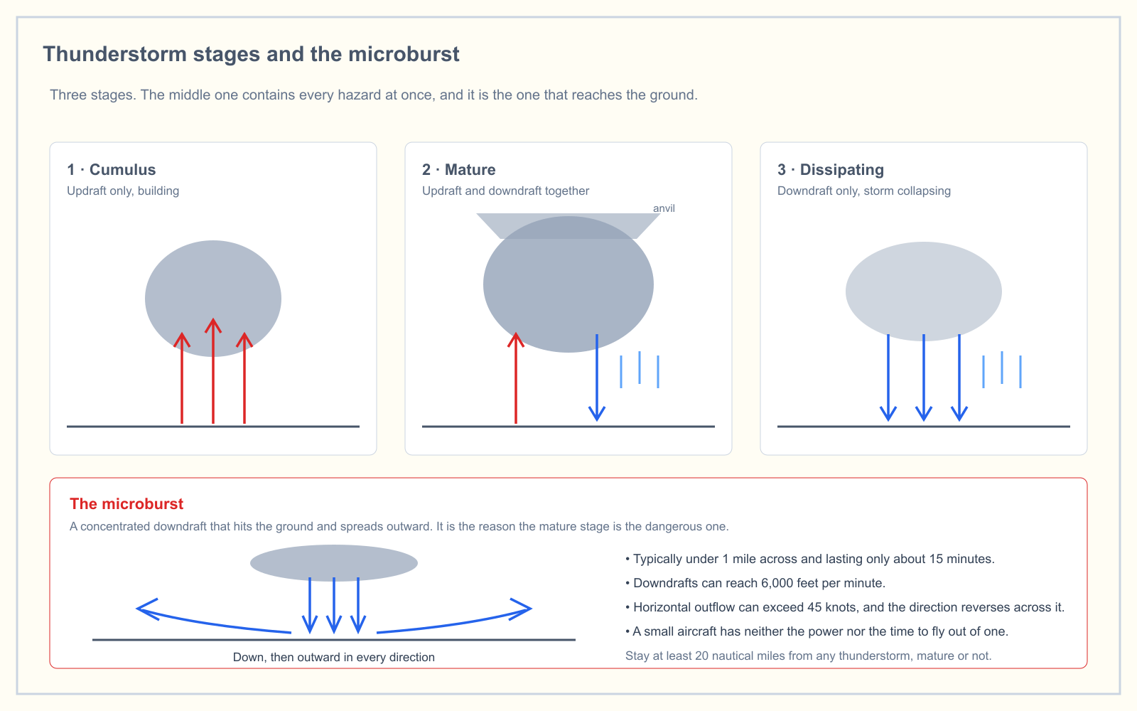
Here is the part worth memorizing. Any convective SIGMET implies severe or greater turbulence, severe icing, and low-level wind shear — those hazards are never spelled out in the text because they are assumed. The exam likes this, and so does reality.
Bulletins go out hourly at H+55 for three regions: western, central and eastern, divided at 87 and 107 degrees west longitude. If nothing qualifies, the message "CONVECTIVE SIGMET... NONE" is issued anyway, so silence is informative. The forecast portion is valid for up to 1 hour, which is a very short leash and tells you how quickly these situations move. Convective SIGMETs are not issued for Alaska or Hawaii.
Our article on thunderstorm stages and the microburst works through what is actually happening inside the cell that triggers one of these.
Are AIRMETs still a thing? What changed on 27 January 2025
Yes, but not in the form most study material describes.
Effective on or about 27 January 2025 at 1900 UTC, the National Weather Service retired the Traditional Alphanumeric Code (TAC) AIRMET over the six regions of the contiguous United States. That is 18 products in total, being Sierra, Tango and Zulu for each of the six regions. The change came from NWS Service Change Notice 24-92, issued in September 2024 after an FAA working group recommended the retirement and an FAA Safety Risk Management Panel evaluated the hazards. The FAA then formally requested it.
What replaced it was already running. The Aviation Weather Center began operational production of the Graphical AIRMET (G-AIRMET) in 2010, issued against the same criteria as the textual product. The G-AIRMET is valid at discrete times no more than 3 hours apart, out to 12 hours, rather than smearing a single hazard area across a six-hour block, which is why it is a better product and not merely a different one.
Two things did not change:
- Alaska and Hawaii still issue textual AIRMETs. Alaska's are valid up to 8 hours and issued every 8; Hawaii's are valid up to 6 hours and issued every 6. If you learned to decode
AIRMET SIERRA FOR IFR AND MT OBSC VALID UNTIL 242115, that skill is still live north and west of the CONUS. - The letters survived. Query the Aviation Weather Center's G-AIRMET feed today and every record still carries a product of SIERRA, TANGO or ZULU.
There is one gap worth knowing about. The G-AIRMET's snapshots are valid at a time, not across a period. If the 00-hour graphic shows nothing and the 03-hour graphic shows a hazard, the AIM tells you to assume the hazard begins immediately after the 00-hour forecast. Do not read a clean snapshot as a clean three hours.
How to decode an AIRMET or SIGMET
Textual advisories read in a fixed order, and once you see the pattern they stop looking like noise. Take the SIGMET example from AIM 7-1-6:
SIGMET ROMEO 2 VALID UNTIL 051000
ME NH VT
FROM CAR TO YSJ TO CON TO MPV TO CAR
OCNL SEV TURB BLW 080 EXP DUE TO STG NWLY FLOW. CONDS CONTG BYD 1000Z.
Line by line: the designator and sequence number, then the valid-until time in UTC. The states affected. The bounding points, given as VORs or airports, which trace the perimeter of the hazard area. Then the hazard itself — occasional severe turbulence below 8,000 feet, expected because of strong northwesterly flow, continuing beyond 1000Z.
Flight levels are the trap. BLW 080 means below 8,000 feet, not 80 feet. The same three-digit hundreds convention you already use for cloud heights in a METAR applies here.
Which of these actually changes a Part 107 decision
Under 14 CFR 107.49, the remote pilot in command must assess the operating environment before flight, and local weather conditions are the first item on that list. In-flight advisories are part of how you do that. But they are written for aircraft operating across a route at altitude, and you are operating one aircraft below 400 feet within visual line of sight, so they do not all carry the same weight.
| Advisory | Does it change your go decision? |
|---|---|
| Convective SIGMET | Yes. Do not fly. It implies severe turbulence, severe icing and low-level wind shear in the same breath |
| AIRMET Sierra (IFR) | Yes. A ceiling below 1,000 feet or visibility below 3 miles puts you against 14 CFR 107.51 directly |
| AIRMET Tango (surface winds, LLWS) | Yes. Sustained surface winds over 30 knots exceed most small multirotors, and low-level wind shear sits in exactly your altitude band |
| AIRMET Tango (turbulence) | Usually. Check whether it is TURB-LO or TURB-HI; the high-level one is above you |
| AIRMET Zulu (icing, freezing level) | Rarely. Moderate icing forecasts are for aircraft in cloud, and you are legally 500 feet below one. The freezing level still tells you about battery performance |
| AIRMET Sierra (mountain obscuration) | Rarely, unless you are launching from high terrain into it |
| Non-convective SIGMET | Situationally. Volcanic ash and widespread dust storms ground you; severe CAT is usually well above your operating altitude |
Sierra's IFR criterion is the one that maps most cleanly onto your own rules. Section 107.51 requires 3 statute miles of flight visibility from the control station and 500 feet of separation below any cloud. An AIRMET Sierra says a large area is expected to be at or below 1,000-foot ceilings and 3-mile visibility, which is a broad-brush way of saying the whole region is close to your legal limit. It is not a substitute for the VFR weather minimums worked at your actual site, but it tells you whether to bother driving there.
Frequently asked questions
What is the difference between an AIRMET and a SIGMET?
Intensity, not phenomenon. An AIRMET covers moderate hazards that threaten light aircraft — IFR conditions, moderate turbulence, moderate icing, surface winds over 30 knots. A SIGMET covers severe or extreme hazards that threaten all aircraft — severe icing, severe or extreme turbulence, volcanic ash and widespread dust storms. Both can describe turbulence; only the severity differs.
Are AIRMETs still a thing?
Yes. The textual AIRMET over the contiguous United States was retired on 27 January 2025 and replaced by the Graphical AIRMET, which uses identical criteria and is still labeled Sierra, Tango and Zulu. Alaska and Hawaii continue to issue textual AIRMETs unchanged, valid up to 8 and 6 hours respectively.
What are the three AIRMETs?
Sierra covers IFR conditions and widespread mountain obscuration. Tango covers moderate turbulence, sustained surface winds greater than 30 knots, and non-convective low-level wind shear below 2,000 feet AGL. Zulu covers moderate icing and freezing levels. The three names survived the 2025 move to a graphical-only product over the lower 48.
What are the three types of SIGMETs?
The practical division is non-convective SIGMETs, convective SIGMETs, and SIGMETs issued for tropical cyclones or volcanic ash, which carry a 6-hour validity rather than the standard 4. Only convective SIGMETs cover thunderstorms; the non-convective product explicitly excludes any turbulence or icing associated with them.
How long is a convective SIGMET valid?
The forecast portion is valid for up to 1 hour. Bulletins are issued hourly at 55 minutes past the hour for the western, central and eastern United States, and a continuing phenomenon is reissued every hour with a new sequence number. If nothing meets the criteria, "CONVECTIVE SIGMET... NONE" is issued for that region anyway.
Do drone pilots need to check AIRMETs and SIGMETs?
Yes, as part of the preflight assessment required by 14 CFR 107.49. In practice a convective SIGMET or an AIRMET Sierra should stop a flight outright, an AIRMET Tango for surface winds usually should, and an AIRMET Zulu for icing rarely matters at or below 400 feet AGL because you are legally clear of cloud anyway.
Weather is only 5 percent of the Unmanned Aircraft General knowledge test, but it is the area candidates most often leave until last. The free readiness assessment mixes weather questions in with the other four areas so you find out where you actually stand.
Sources
- FAA Aeronautical Information Manual 7-1-6 — Inflight Aviation Weather Advisories
- 14 CFR 107.49 — Preflight familiarization, inspection, and actions for aircraft operation
- 14 CFR 107.51 — Operating limitations for small unmanned aircraft
- NWS Service Change Notice 24-92 — Retirement of the AIRMET over CONUS
- Aviation Weather Center — Graphical AIRMET
- FAA Airman Certification Standards
Put this guide into practice.
Take the free assessment to see how this topic fits into your current exam readiness.
Start free practice