Weather
Thunderstorm Stages and the Microburst
A thunderstorm carries every hazard in aviation at once, and it packs them into the middle of its life cycle.
Key takeaway
The mature stage carries updraft, downdraft, hail, lightning and wind shear simultaneously. A microburst can produce 6,000 feet-per-minute downdrafts and reverse the wind across its width in seconds.
Every thunderstorm passes through three stages — cumulus, mature and dissipating — and every hazard aviation cares about is packed into the middle one. The mature stage is the only stage with an updraft and a downdraft running at the same time, and it is the stage that produces the microburst: a concentrated column of sinking air that hits the ground and spreads outward in every direction.
The FAA's guidance for small aircraft is not subtle. Stay at least 20 nautical miles from any thunderstorm, at any stage.
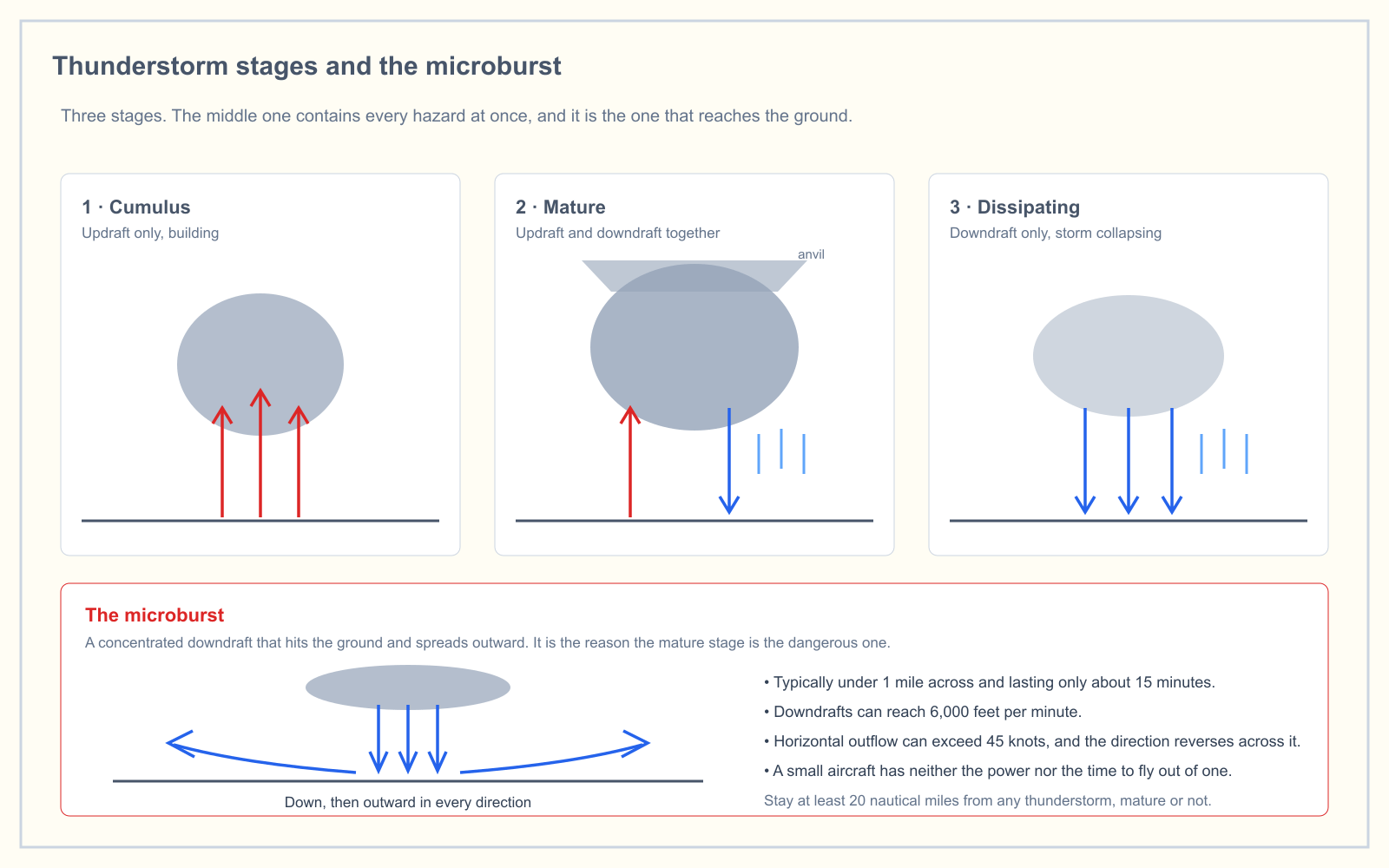
The three stages
Stage 1 — cumulus: updraft only
The storm is built by rising air. Warm, moist air lifted by heating, terrain or a frontal boundary keeps rising because it is warmer than its surroundings, and as it cools past its dew point the moisture condenses into a visible cloud.
The whole cell is one updraft at this point, sometimes exceeding 3,000 feet per minute. Water droplets are being carried upward, not falling, so there is little or no precipitation reaching the ground. The cell can grow through 20 to 30 minutes of this, building vertically the entire time.
The identifying feature is a towering cumulus with sharp, cauliflower edges and no anvil.
Stage 2 — mature: updraft and downdraft together
The mature stage begins the moment precipitation starts falling out of the base. Falling rain drags air down with it, and evaporating rain cools that air, making it denser and accelerating the descent. Now the cell has both an updraft and a downdraft, side by side.
This is where everything happens at once:
- Heavy precipitation
- Lightning
- Hail, sometimes thrown clear of the cloud
- Severe turbulence at the boundary between the up and down currents
- Wind shear
- The microburst
- An anvil top, spread by winds at the tropopause, pointing in the direction the storm is moving
The mature stage typically lasts 15 to 30 minutes. It is the most intense and the most dangerous phase, and it is the only one in which both currents coexist.
Stage 3 — dissipating: downdraft only
Eventually the downdraft spreads through the whole cell and chokes off the supply of warm moist air feeding the updraft. Without that inflow the storm starves. Precipitation weakens, the cloud loses definition, and the anvil is often the last part left.
A dissipating cell is still not safe. The downdraft is still there, and the outflow at the surface can still produce a strong gust front miles from the visible cloud.
What builds a thunderstorm in the first place
Three ingredients are required, and all three must be present:
- Moisture. Water vapor to condense, which supplies both the cloud and the latent heat that drives the updraft.
- Unstable air. An atmosphere in which a lifted parcel keeps rising rather than settling back. See stable and unstable air for what that actually means.
- A lifting action. Something to start the parcel moving — surface heating, terrain, converging surface winds, or a frontal boundary.
Remove any one and you do not get a thunderstorm. This is why a humid, unstable morning can pass without incident until the afternoon sun supplies the missing lift, and why the same air mass produces storms along a mountain range and nothing over the flatland beside it.
Types by how they are triggered
| Type | Trigger | Character |
|---|---|---|
| Air mass | Surface heating, usually afternoon | Isolated, scattered, generally brief |
| Orographic | Air forced up over terrain | Anchored to the terrain, persistent while the wind holds |
| Frontal | Lifting along a front, usually cold | Organized in a line along the boundary |
| Squall line | Ahead of a fast-moving cold front | Often the most severe; can form 50 to 300 miles ahead of the front |
The squall line is the one that surprises people, because it forms in air that looks unremarkable on a surface analysis and is nowhere near the plotted frontal position.
Embedded thunderstorms are a separate hazard: cells buried inside a wider layer of stratiform cloud, invisible from outside. They are principally an IFR problem, but they matter to a remote pilot for one reason — an overcast day with no visible convection is not proof that there is none.
The microburst
A microburst is a small, intense downdraft that hits the ground and spreads horizontally in all directions. The scale is what makes it dangerous — it is too small to appear on most weather products, and too short-lived to be forecast usefully.
| Property | Figure |
|---|---|
| Diameter | Typically less than 1 statute mile |
| Total duration | About 15 minutes, with peak intensity in the middle 2 to 4 minutes |
| Downdraft speed | Up to 6,000 feet per minute |
| Horizontal outflow | Can exceed 45 knots |
| Total wind change across it | Can approach 90 knots between the headwind and tailwind sides |
That last row is the killer. An aircraft flying through a microburst first meets a headwind — performance improves, and the natural reaction is to correct downward. Then it passes through the core, where the wind is straight down. Then it exits into a tailwind, and the airspeed that was there a moment ago is gone.
For a manned aircraft on approach, that sequence has caused fatal accidents. For a small drone, the numbers are worse in one specific way: a 45-knot outflow exceeds the 87-knot groundspeed limit's practical margin for most multirotors, and no small UAS has the power or the time to fly out of one.
Dry microbursts deserve a mention because they defeat the obvious visual cue. When the air below the cloud base is dry, the rain evaporates before it reaches the ground and there is no visible shaft of precipitation. What you see instead is virga — precipitation trailing from a cloud base and vanishing before it lands — and sometimes a ring of blowing dust at the surface. Virga under a convective cloud is a microburst warning.
What a remote pilot should actually do
- Twenty nautical miles. From any thunderstorm, at any stage. Not from the rain shaft — from the cell.
VCTSin a METAR means 5 to 10 statute miles. That is inside the avoidance distance while the report still shows good visibility on the field.- Watch for virga. Trailing precipitation that never reaches the ground under a convective cloud is a dry microburst signature.
- A gust front arrives before the storm. The outflow from a mature cell can produce a sharp wind shift and a 20-to-30-knot gust several miles ahead of the cloud, on a day that still looks flyable at your site.
- Do not fly under an overhanging anvil. Hail and lightning are both thrown well clear of the main cell.
- Land early rather than watching. A cell that goes from cumulus to mature in 20 minutes gives you less warning than it feels like it does.
Frequently asked questions
What are the three stages of a thunderstorm?
The three stages are cumulus, mature and dissipating. The cumulus stage has an updraft only and the cell is building. The mature stage has an updraft and a downdraft simultaneously and contains every thunderstorm hazard. The dissipating stage has a downdraft only and the cell is collapsing.
Which stage of a thunderstorm is the most dangerous?
The mature stage. It is the only stage in which an updraft and a downdraft exist at the same time, and it produces heavy precipitation, lightning, hail, severe turbulence, wind shear and microbursts together.
What is a microburst?
A microburst is a concentrated downdraft from a convective cloud that strikes the ground and spreads outward in all directions. It is usually under 1 statute mile across, lasts about 15 minutes, can produce downdrafts of 6,000 feet per minute, and can generate horizontal outflow above 45 knots.
How far should you stay from a thunderstorm?
FAA guidance is to remain at least 20 nautical miles from a thunderstorm. That distance is measured from the cell, not from the visible rain, because hail and severe turbulence can occur well outside the precipitation area.
What is virga and why does it matter?
Virga is precipitation that falls from a cloud base and evaporates before reaching the ground. Under a convective cloud it is a warning sign of a dry microburst — a strong downdraft with no visible rain shaft to mark it.
Can a drone fly out of a microburst?
No. A small unmanned aircraft has neither the excess power nor the time. A microburst reaches peak intensity within a few minutes and can produce a total wind change approaching 90 knots across its width, which is far beyond the control authority of a small multirotor.
Thunderstorms, stability and fronts are one connected topic on the knowledge test. Check where you stand with the free readiness assessment.
Sources
Put this guide into practice.
Take the free assessment to see how this topic fits into your current exam readiness.
Start free practice