Weather
Wind Shear in Aviation: Where It Hides Below 400 Feet, and What It Does to a Drone
Low-level wind shear is defined as occurring within 2,000 feet of the surface. Every legal Part 107 flight sits inside that layer, in the bottom fifth of it.
Key takeaway
The FAA defines non-convective low-level wind shear as 10 knots or more per 100 feet in a layer over 200 feet thick, within 2,000 feet of the surface. Your entire 400-foot envelope sits inside that layer.
Wind shear is a sudden change in wind speed, wind direction, or both, over a short distance. The FAA defines non-convective low-level wind shear as 10 knots or more per 100 feet, in a layer more than 200 feet thick, occurring within 2,000 feet of the surface. Every legal Part 107 flight happens inside that layer.
That last sentence is the whole reason this topic belongs on a drone site. Wind shear is taught as an approach-and-landing hazard, because that is when an airliner is slow, low and out of options. The literature, the training films and the accident reports are all written for a crew at 500 feet on final. But the altitude band the FAA singles out as the dangerous one runs from the surface to 2,000 feet, and 14 CFR 107.51 caps you at 400 feet AGL. You do not descend into the wind shear layer. You launch into it and stay there.
What is wind shear in aviation?
The Aviation Weather Handbook defines it as the sudden, drastic change in wind speed or direction over a small area, from one level or point to another, usually in the vertical. The key word is change. A steady 25-knot wind is not shear. A 5-knot wind at the surface sitting under a 35-knot wind at 300 feet is shear, and it is the boundary between them that hurts.
Shear occurs in all directions, but it is measured along two axes for convenience, which gives you the two terms you will meet on the exam:
- Vertical wind shear — the wind changes as you climb or descend. This is the common case and the one that matters below 400 feet.
- Horizontal wind shear — the wind changes as you move laterally at a constant altitude. Think of crossing a shoreline or flying out from behind a building.
Some publications add the term severe wind shear, defined as shear that exceeds the performance capability of the aircraft, or that produces airspeed changes greater than 15 knots or vertical speed changes greater than 500 feet per minute. Those thresholds were written for airplanes. A small multirotor has a fraction of that margin.
What is an important characteristic of wind shear?
This is a question the knowledge test asks close to verbatim, and the answer is the one line worth memorizing: wind shear can be present at any altitude, and it can exist in both a horizontal and a vertical direction.
That phrasing is doing real work. Candidates who learn wind shear as "the thing under thunderstorms" get the question wrong, because the stem is testing whether you know it is not tied to convection, not tied to a particular height, and not tied to one axis. Clear, calm, cloudless conditions can produce a shear layer strong enough to end a flight.
Where does wind shear occur? The five sources
| Source | Where and when | Convective? |
|---|---|---|
| Temperature inversion | Overnight and at dawn, with a fast wind sitting on top of a calm surface layer | No |
| Frontal zone | As a front passes, where two air masses of different temperature and wind meet | No |
| Terrain and structures | Downwind of ridges, tree lines, hangars and buildings; wind accelerating through gaps | No |
| Sea and lake breeze | At the boundary where onshore flow undercuts warmer inland air | No |
| Thunderstorm and microburst | Under and around convective cloud, including virga with no rain reaching the ground | Yes |
Four of the five are non-convective, which means they arrive without the visual warning a thunderstorm gives you. The handbook notes that non-convective low-level wind shear is commonly associated with passing frontal systems, temperature inversions, and strong upper-level winds greater than 25 knots.
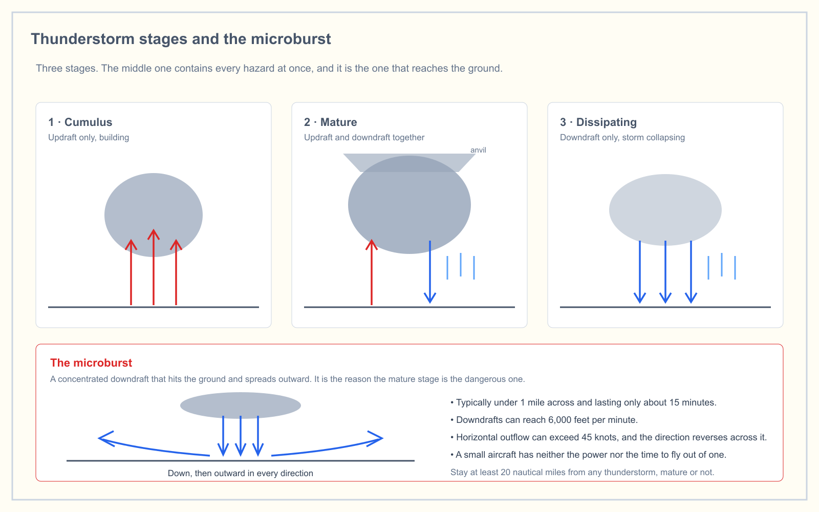
The convective case is the most violent by a wide margin and it has its own article. A microburst can produce downdrafts of 6,000 feet per minute and a total wind change approaching 90 knots across its width, which is why the only correct answer is distance. The detail is in thunderstorm stages and the microburst.
Wind shear and the temperature inversion
This is the source that catches drone pilots, because it happens on exactly the morning that looks perfect for flying.
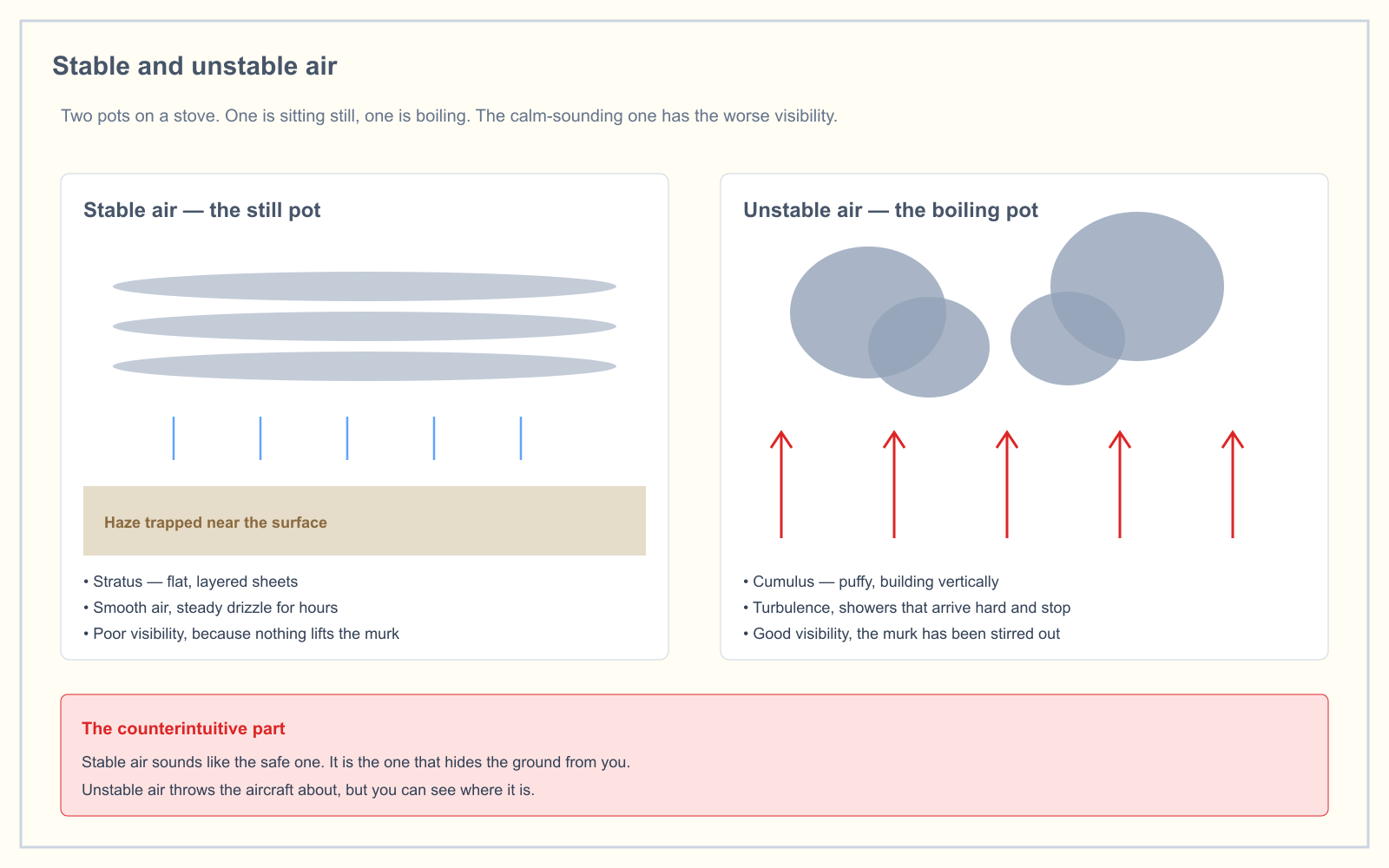
Overnight radiational cooling chills the ground, which chills the air touching it. By dawn you have a layer of cold, dense, very stable air a few hundred feet deep, with warmer air above it. Because the layer is stable, nothing mixes through it. The wind above is free to blow at its own speed without dragging the surface air along, and a low-level jet can form right on top of the inversion.
Stand under that at 6 a.m. and you feel nothing. The trees are still, the windsock hangs, the METAR says calm. Climb through the top of the inversion and the aircraft meets a 30-knot wind in the space of a few seconds. The handbook lists three ways inversions form near the surface: nighttime radiational cooling, frontal zones, and cold air trapped in a valley. All three are launch-site conditions. More on why the calm morning is the deceptive one in stable vs unstable air.
How wind shear reaches you in a weather product
Almost no drone-focused page covers this, and it is the part that actually changes a go or no-go decision. Wind shear shows up in six places:
| Product | How it appears |
|---|---|
| TAF | A WS group, such as WS020/27055KT |
| AIRMET Tango | Issued when non-convective LLWS potential below 2,000 feet AGL is occurring or expected |
| PIREP | Reported in the remarks section |
| ATIS | LLWS or microburst is broadcast for 20 minutes after the last report |
| Convective SIGMET | Possible LLWS is implied within the SIGMET area |
| LLWAS | Ground sensors at larger airports alert on shear of ±15 knots |
The TAF group is the one people decode wrong, so read it slowly. In WS020/27055KT, the three digits after WS are the top of the shear layer in hundreds of feet, not the amount of shear. Shear is forecast from the surface up to 2,000 feet. The five digits after the solidus are the wind at the top of that layer — from 270 degrees at 55 knots. It is not a shear value. Pair it with the surface wind in the same forecast to see the size of the change. If the surface group reads 13012KT, you have a wind going from southeast at 12 to west at 55 in 2,000 feet. That is a complete reversal.
One trap in the METAR. WSHFT 30 FROPA in the remarks is a wind shift, not wind shear — it records the time the wind shifted and notes a frontal passage. Useful, related, different thing. The TAF decoding walkthrough is in how to read a TAF, and the product differences are in AIRMET vs SIGMET.
What wind shear does to a multirotor
A manned aircraft in shear loses or gains airspeed, and therefore lift. The pilot sees it on an instrument and has a trained response. You have neither.
Your aircraft holds position by GPS and attitude. Fly it into a shear layer and it does not tell you the wind changed. It tilts harder to hold the waypoint, draws more current to do it, and the visible result is a drone that is suddenly leaning at an angle you did not command. Three things follow:
- Ground track goes wrong before anything else does. In a strong shear the aircraft can be at full tilt and still drifting downwind, which reads as a control failure and is not one.
- Endurance collapses without warning. Holding against 30 knots costs far more current than holding against 5, so the battery percentage you planned the flight around stops being true partway through the climb.
- The descent is the dangerous part. Coming back down through the shear boundary into calm air, the aircraft is still commanding a large tilt against a wind that just vanished, and it lurches. Below 400 feet there is very little room for a lurch.
What this means when you are actually working
14 CFR 107.49 requires you to assess the operating environment, including local weather conditions, before every flight. Wind shear is part of that assessment, and the practical version is short.
Check the TAF for a WS group and the Graphical AIRMET for Tango before you leave. On site, do not trust the surface wind alone — a calm launch pad at dawn is a specific warning sign, not a green light. Climb slowly on the first flight of the day and watch the aircraft's attitude rather than its altitude; the tilt tells you what the wind is doing long before the telemetry does. If it leans hard at 150 feet, come down and reconsider, because the layer above is worse.
And if there is convection anywhere near, the answer is not a technique. It is distance.
How the exam asks about wind shear
Weather is 5 percent of the Unmanned Aircraft General knowledge test under the blueprint effective 29 September 2025, so this is a handful of questions rather than a section. They come in three shapes:
- The characteristic question. Any altitude, horizontal and vertical. Distractors tie it to thunderstorms only, or to low altitudes only.
- The conditions question. Hazardous low-level shear is commonly found with a strong temperature inversion and near thunderstorms. The inversion half is the one candidates miss.
- A TAF or METAR reading. You are given a report and asked what the
WSgroup means, or which report shows shear. Drill the format in the METAR practice trainer rather than reading decoded summaries.
Frequently asked questions
When may hazardous wind shear be expected?
Hazardous low-level wind shear is commonly encountered near the ground during periods of strong temperature inversion and in the vicinity of thunderstorms. The FAA also lists frontal passages and strong upper-level winds above 25 knots as common non-convective causes. It can occur at any altitude, in clear air, with no visual warning.
What is low-level wind shear?
The FAA defines non-convective low-level wind shear as a wind shear of 10 knots or more per 100 feet, in a layer more than 200 feet thick, occurring within 2,000 feet of the surface. It is singled out because an aircraft that close to the ground has no altitude in which to recover, which applies to every Part 107 flight.
What does WS mean in a TAF?
WS marks a forecast low-level wind shear group. The three digits that follow are the top of the shear layer in hundreds of feet, and the wind group after the solidus is the wind at that top, not the amount of shear. In WS020/27055KT, shear runs from the surface to 2,000 feet, where the wind is 270 degrees at 55 knots.
Is wind shear the same as turbulence?
No, though one causes the other. Wind shear is the change in wind between two points; turbulence is the chaotic motion generated where those two wind currents meet. You can encounter shear as a smooth, sustained push rather than a rough ride, which is part of why it goes unrecognized.
Can a drone fly in wind shear?
It depends entirely on the magnitude. A small multirotor typically has a manufacturer wind resistance rating in the region of 20 to 25 knots, and a shear layer that puts a 30-knot wind at 300 feet over a calm surface exceeds that with no warning from the ground. Check the TAF and climb cautiously.
Does wind shear show up in a METAR?
Not as a forecast group. A METAR may carry a wind shear report in the remarks section from an automated system or a pilot report, and larger airports run LLWAS sensors that alert at ±15 knots. WSHFT in the remarks is a wind shift, which is a different thing. The forecast WS group belongs to the TAF.
Weather questions are only 5 percent of the test, which means they are easy to under-study and expensive to guess at. The free readiness assessment mixes them in with the other four areas so you can see where you actually stand.
Sources
- FAA-H-8083-28B, Aviation Weather Handbook — Chapter 19, Turbulence, sections 19.2.3 and 19.2.4
- Aviation Weather Handbook, full text (FAA) — LLWS definition, TAF wind shear group encoding, and the wind shear product table
- 14 CFR 107.49 — Preflight familiarization, inspection, and actions for aircraft operation
- 14 CFR 107.51 — Operating limitations for small unmanned aircraft
- Aeronautical Information Manual, Chapter 7 Section 1 — Meteorology
- Graphical Forecasts for Aviation, Aviation Weather Center
Put this guide into practice.
Take the free assessment to see how this topic fits into your current exam readiness.
Start free practice