Flight Operations
How to Read the FAA Chart Supplement: The Airport Entry, Line by Line
The sectional shows you where the airport is. The Chart Supplement tells you when it is open, what altitude the traffic flies, and which frequency to monitor.
Key takeaway
The Chart Supplement carries the airport data a sectional chart cannot hold: hours, lighting, fuel, CTAF and traffic pattern altitude. The legend that decodes it, keyed to a numbered sample entry, sits in the front matter of every volume.
The Chart Supplement is the FAA publication that carries the airport data a sectional chart has no room for: hours of operation, fuel, lighting codes, traffic pattern altitude, CTAF. The FAA issues it every 56 days, in seven volumes covering the conterminous US plus one each for Alaska and the Pacific.
Almost nobody teaches it. Search for the legend and one of the top results is a forum thread asking whether a legend exists at all. It does. It sits in the front matter of every single volume, keyed to a numbered sample entry, and it has been there the whole time.
What is a chart supplement in aviation?
AIM 9-1-4 defines the Chart Supplement as a series of civil and military flight information publications issued every 56 days, consisting of the Chart Supplement U.S., Chart Supplement Alaska, and Chart Supplement Pacific. Nine books in total, since the U.S. edition is split into seven geographic volumes.
The AIM gives the reason it exists in one sentence: the Chart Supplement "shows data that cannot be readily depicted in graphic form; for example, airport hours of operations, types of fuel available, run widths, and lighting codes."
That is the whole relationship between the two publications. A sectional chart is a picture, and a picture can only hold so much. When the chart wants to tell you something it cannot draw, it points at the Chart Supplement instead. The FAA's own Aeronautical Chart Users' Guide does this constantly, for runway lighting limitations, for part-time frequencies, for asterisked right-traffic restrictions, and for runway surface treatment.
The publication was formerly called the Airport/Facility Directory. It was renamed, but only on the cover. Open any volume today and the directory section inside is still headed AIRPORT/FACILITY DIRECTORY, which is why so many pilots use both names for the same book.
Where to find the chart supplement legend
Three places, and only one of them is the one people look in first.
| Where | What you get |
|---|---|
| Front matter of any volume | The full legend, keyed to a numbered SAMPLE entry. This is the real answer |
| Digital Chart Supplement (d-CS) | Free PDFs, current and next cycle, searchable by identifier |
| Aeronautical Chart Users' Guide | Not here. It explains the charts and repeatedly refers you onward |
The d-CS is a free download, and the next edition posts roughly 20 days before it takes effect. The Pacific volume current as this is written runs 3 September to 29 October 2026 — exactly 56 days, printed on the bottom of every page.
The header line
Here is the FAA's own sample entry, from the legend itself:
CITY NAME
  AIRPORT NAME (ALTERNATE NAME) (LTS)(KLTS) CIV/MIL 3 N UTC-6(-5DT) N34°41.93´ W99°20.20´
| Field | Sample | What it means |
|---|---|---|
| City and airport name | CITY NAME / AIRPORT NAME | Listed alphabetically by state, then associated city |
| Alternate name | (ALTERNATE NAME) | In parentheses, if any |
| Location identifier | (LTS)(KLTS) | Three or four character FAA code, then the ICAO code where assigned |
| Operating agency | CIV/MIL | Shown only for military, private-use and joint-use fields |
| Airport location | 3 N | 3 nautical miles north of the center of the associated city |
| Time conversion | UTC-6(-5DT) | Hours to subtract from UTC for local standard and local daylight time |
| Geographic position | N34°41.93´ W99°20.20´ | The airport reference point, the approximate geometric center of all usable runway surfaces |
Two small things worth knowing. Zeros in the identifier are printed with a slash through them so you cannot confuse them with the letter O. And out in the right margin of the entry, the legend prints the name of the sectional chart the airport appears on, which is a fast way to confirm you are looking at the right chart before a job.
The second line, where the exam questions live
200 B TPA—1000(800) AOE LRA Class IV, ARFF Index A NOTAM FILE ORL Not insp. MON Airport
| Token | Meaning |
|---|---|
| 200 | Field elevation: the highest point of the airport's usable runways, in feet MSL |
| B | A rotating beacon is available. Beacons run sunset to sunrise unless the remarks say otherwise |
| TPA—1000(800) | Traffic pattern altitude, MSL first, AGL in parentheses |
| AOE, LRA | Airport of entry, landing rights airport |
| NOTAM FILE ORL | The identifier you use to pull NOTAMs for this field |
| Not insp. | The FAA has not inspected the data recently |
Elevation is not the average of the field, and it is not the terminal. It is the highest point of usable runway. If you are working out an above-ground-level ceiling against a published MSL figure, that is the number the FAA intends you to use.
Traffic pattern altitude, and why there are two numbers
TPA—1000(800) means the pattern is flown at 1,000 feet MSL, which is 800 feet above the field. The difference is the 200-foot field elevation. Same altitude, two frames of reference, and the exam will pick whichever one you are less likely to be holding.
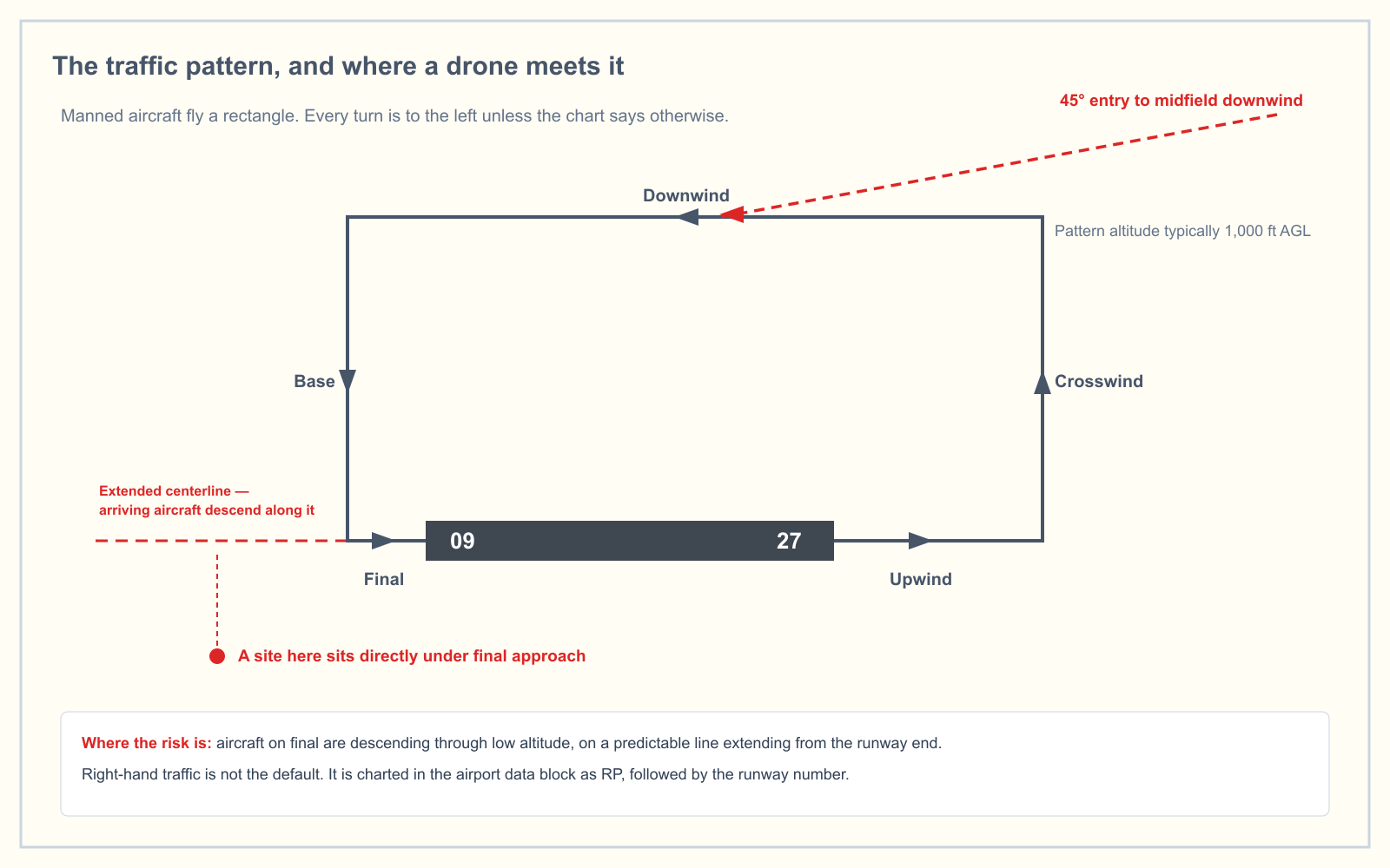
The legend adds a detail most study material skips: a TPA is published only when it differs from the recommended altitudes in the AIM. If the entry has no TPA line, that is not missing data. It means the field uses the standard.
Direction of turns lives elsewhere. It appears in the runway end data as Rgt tfc, meaning that runway end uses a right-hand pattern instead of the standard left. Get that backward and you are watching the wrong side of the field for arriving traffic. The guide to non-towered airports covers what the pattern looks like from the ground.
The runway data block
RWY 18-36: H12004X200 (ASPH-CONC-GRVD) S-90, D-160, 2D-300 PCN 80 R/B/W/T HIRL CL
  RWY 18: RLLS. MALSF. TDZL. REIL. PAPI(P2R). Thld dsplcd 300´. Trees. Rgt tfc. 0.3% up.
| Element | Reading |
|---|---|
H prefix | Hard surface. No prefix means sod, clay, gravel or similar |
12004X200 | 12,004 feet long by 200 feet wide |
(ASPH-CONC-GRVD) | Asphalt and concrete, grooved |
S-90, D-160 | Weight bearing capacity in thousands of pounds. S is single-wheel gear, D is dual. Add three zeros: S-90 is 90,000 lb |
HIRL | High intensity runway lights. LIRL is low, MIRL is medium |
CL | Centerline lights |
Thld dsplcd 300´ | The threshold is displaced 300 feet |
Rgt tfc | Right-hand traffic pattern for that runway end |
Runway lights run sunset to sunrise unless the entry says otherwise. Where lighting is pilot-controlled or available by prior arrangement, the entry says so, which is how a runway can go from dark to fully lit at two in the morning because somebody keyed a microphone seven times.
What does S4 mean on a chart supplement?
S4 means major airframe and major powerplant repairs are available. It appears under SERVICE: and it is the fourth of eight service codes:
| Code | Available |
|---|---|
| S1 | Minor airframe repairs |
| S2 | Minor airframe and minor powerplant repairs |
| S3 | Major airframe and minor powerplant repairs |
| S4 | Major airframe and major powerplant repairs |
| S5 | Major airframe repairs |
| S6 | Minor airframe and major powerplant repairs |
| S7 | Major powerplant repairs |
| S8 | Minor powerplant repairs |
This is the single most confusing pair of codes in the publication, because the same letter does a completely different job two lines earlier. S4 in the SERVICE line is a repair shop. S-90 in the runway line is pavement strength. One has a hyphen and lives with the runway dimensions. The other does not and lives with the fuel.
Communications, weather and airspace
The communications line is not in a random order. The legend specifies the sequence: single frequency approach, then CTAF, then UNICOM, then ATIS, and where CTAF and UNICOM are the same frequency it is printed once as CTAF/UNICOM. Tower, ground and clearance delivery follow underneath.
WEATHER DATA SOURCES gives you the automated station and its frequency, and it distinguishes between them. An AWOS-A reports altimeter setting only, with everything else advisory. An ASOS reports what an AWOS-3 does plus precipitation identification and intensity. If you are relying on a field observation for a launch decision, it matters which one is actually there.
AIRSPACE names the class and, critically, its hours. An entry reading AIRSPACE: CLASS D svc 1200-0400Z‡ other times CLASS G is telling you that the same piece of sky needs authorization for part of the day and none for the rest. That double dagger means the times shift one hour earlier during daylight saving time.
What this means when you are actually working
14 CFR 107.49 requires the remote pilot in command to assess the operating environment before flight, including local airspace and any flight restrictions. 14 CFR 107.43 is blunter: you may not operate in a manner that interferes with operations and traffic patterns at any airport, heliport or seaplane base.
You cannot avoid a traffic pattern you have not looked up. For a job within a couple of miles of a field, the Chart Supplement gives you four things in about thirty seconds:
- The CTAF, so you can listen to arrivals rather than guess
- The TPA, so you know what altitude the traffic above you is flying
Rgt tfc, so you are watching the correct side of the field- Attended hours, so you know whether anyone is there at all
None of that is on the sectional. All of it changes where you would choose to stand.
How the exam asks about it
Under the test blueprint effective 29 September 2025, Regulations is 48% of the UAG exam and Airspace is 20%. Airport data questions sit in both. They are rarely phrased as "what does the Chart Supplement say" — they hand you an excerpt and ask for a number, usually field elevation, traffic pattern altitude, or a frequency.
This gets more important, not less. From 27 October 2026, the UAG test includes image-based questions using images that are not in the printed testing supplement. Memorizing a figure number stops working at that point. Reading an unfamiliar excerpt does not. The full breakdown of both exam changes covers what else moves.
If your weak spot is the chart rather than the book, the sectional chart symbol guide is the companion to this one.
Frequently asked questions
What is the chart supplement used for?
It carries the airport information that will not fit on a chart: hours of operation, fuel types, lighting codes, runway dimensions and surface, weight bearing capacity, traffic pattern altitude, communications frequencies, airspace class and hours, and airport remarks. Pilots use it alongside a sectional or IFR chart, not instead of one.
Where can I find the chart supplement?
Free from the FAA's Digital Chart Supplement page, as searchable PDFs covering the current and next cycle. Printed volumes are sold by pilot supply retailers. Most electronic flight bag apps also carry the current entry for any airport you look up, though the legend is easier to read in the source PDF.
How often is the chart supplement updated?
Every 56 days, on the same cycle as the airspace charts. Each page prints its own effective range at the bottom, so you can confirm at a glance whether the copy in front of you is current. The FAA posts the next edition around 20 days before it takes effect.
Where do you find traffic pattern altitude on a chart supplement?
On the second line of the airport entry, written as TPA—1000(800). The first figure is MSL, the figure in parentheses is above field elevation. It is published only when it differs from the standard altitudes recommended in the AIM, so an entry with no TPA line is using the standard rather than omitting data.
What is the difference between a sectional chart and a chart supplement?
The sectional is graphic and shows you where things are. The Chart Supplement is text and tells you the things a drawing cannot hold, such as when the field is attended and what frequency to monitor. They are designed to be used together, and the sectional repeatedly points at the supplement for detail.
Does a Part 107 pilot have to use the chart supplement?
Part 107 does not name the publication. It does require you to assess local airspace before flight under 107.49 and to avoid interfering with airport traffic patterns under 107.43. The Chart Supplement is the most direct way to satisfy both, and it is where the exam gets its airport data questions.
Work through real chart excerpts on the sectional chart practice tool and the airport data questions stop being guesswork.
Sources
- AIM Chapter 9, Section 1: Types of Charts Available
- FAA Chart Supplements product page
- FAA Digital Chart Supplement (d-CS)
- FAA Aeronautical Chart Users' Guide
- 14 CFR 107.49 — Preflight familiarization, inspection, and actions for aircraft operation
- 14 CFR 107.43 — Operation in the vicinity of airports
- UAG Applicant Information Bulletin (PSI), effective 29 September 2025
Put this guide into practice.
Take the free assessment to see how this topic fits into your current exam readiness.
Start free practice