Flight Operations
Runway Numbers and Markings: How to Read a Runway from the Ground
Runway 27 points roughly 270 magnetic. That is the easy part. The rest of the paint tells you where aircraft land, where they hold, and where you must not be.
Key takeaway
A runway number is the magnetic azimuth of its centerline with the last digit dropped, so the two ends always differ by 18. Runway markings are white, taxiway and closed-area markings are yellow.
A runway number is its magnetic heading with the last digit dropped. The FAA defines it as the whole number nearest one-tenth the magnetic azimuth of the centerline, measured clockwise from magnetic north. Runway 27 points about 270 degrees magnetic. The opposite end of that same strip is runway 9, and the two ends always differ by 18.
That much most people get. What trips up a remote pilot standing at the fence is everything else painted on the pavement. The white numbers tell you which way traffic is landing. The yellow lines tell you where the airport stops being somewhere you can walk. Both matter before you launch, and neither is on the sectional.
How are runways numbered?
Take the magnetic azimuth of the runway centerline, measured clockwise from magnetic north, and round to the nearest ten degrees. Then drop the trailing zero.
A runway aligned 268 degrees magnetic rounds to 270 and is painted 27. One aligned 083 rounds to 080 and is painted 8. The FAA's wording in AIM 2-3-3 is that the number is determined from the approach direction — you read it as you fly toward it, which is why the number under your feet is the one you would be landing on.
Because a runway is a straight line usable in both directions, every runway carries two numbers 180 degrees apart. Subtract 18 from the higher one, or add 18 to the lower:
| Painted number | Approximate magnetic heading | Opposite end |
|---|---|---|
| 4 | 040 | 22 |
| 9 | 090 | 27 |
| 18 | 180 | 36 |
| 31 | 310 | 13 |
There is no runway 0. Magnetic north is 360, so the northerly runway is 36, not 00. Numbers run 1 through 36 and nothing else.
What do the letters L, C and R mean?
Parallel runways share the same heading, so they need something more than a number to tell them apart. The AIM assigns letters by position as seen from the approach direction:
- Two parallel runways: L and R. So 27L and 27R.
- Three parallel runways: L, C and R.
The letter flips when you look from the other end, which is the part that catches people. The strip painted 27L on its western approach is painted 9R on its eastern one. It is the same pavement. You are just standing at the other end of it.
Why runways get renumbered
Magnetic north moves. The runway does not. Over enough years the drift is large enough that the painted number no longer rounds to the runway's actual magnetic azimuth, and the airport repaints.
This is not theoretical. Tucson International renumbered its runways to reflect current magnetic declination, and they are now 12/30 and 4/22 rather than what pilots there had used for decades (FAA From the Flight Deck). The physical concrete never moved an inch.
For a remote pilot this matters in one specific way: a chart, an app or a memory older than the repaint will name a runway that no longer exists. If the number you expect and the number you can see disagree, the pavement wins.
Magnetic or true? The trap in the wind report
Runway numbers are magnetic. Wind is reported both ways, depending on where you get it, and this is the single most useful thing on this page.
| Source | Wind referenced to |
|---|---|
| METAR or TAF text | True north |
| Winds aloft forecast | True north |
| ATIS, ASOS or AWOS voice broadcast | Magnetic north |
| Tower, giving you the wind | Magnetic north |
AIM 7-1-4 states it plainly: wind direction is reported relative to magnetic north in ATIS as well as ASOS and AWOS radio broadcasts, while the digits in a written METAR are referenced to true north.
So if you pull a METAR reading 27015KT and compare it directly against runway 27, you are comparing a true direction to a magnetic one. In most of the continental US the variation is small enough that it does not change which runway is favored, but in places where variation runs into double digits it can. If you want the comparison to be apples to apples, listen to the AWOS rather than reading the text. Our METAR reading guide covers the rest of the report group by group.
Which runway is in use, and how you tell from the ground
Aircraft take off and land into the wind. The runway in use is the one whose number most closely matches the direction the wind is coming from.
Wind from 250 at a field with runways 9/27 and 18/36? Traffic is using 27, because 270 is much closer to 250 than any other option. That single deduction tells you which end aircraft are approaching from, which is the whole point of working it out. The wind indicators that give you this without a radio — the windsock, the tetrahedron, the segmented circle — are covered in the guide to non-towered airport operations, along with the traffic pattern and what to do about the radio.
The markings, by color and by function
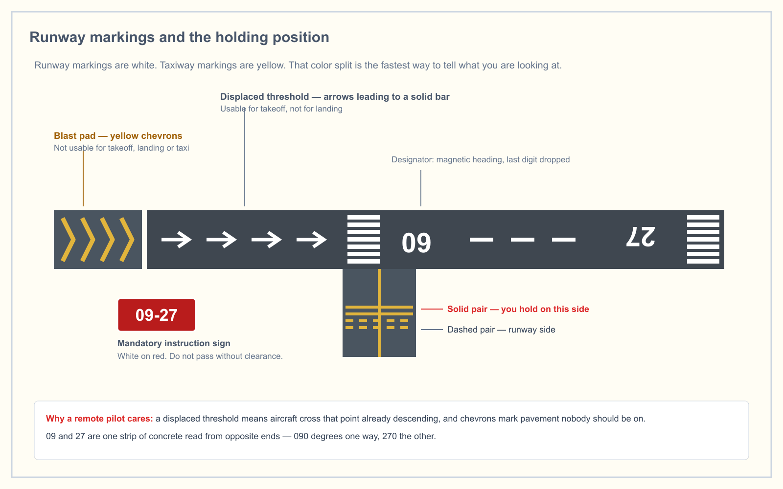
One rule covers most of it. From AIM 2-3-2: markings for runways are white, and markings for taxiways, for areas not intended for use by aircraft, and for holding positions are yellow — even when a holding position marking sits on a runway.
| Marking | Color | What it tells you |
|---|---|---|
| Designator (the number) | White | Magnetic azimuth of that approach direction |
| Centerline | White | Alignment guidance, uniform stripes and gaps |
| Threshold stripes | White | Where the landing surface begins; stripe count encodes width |
| Aiming point | White | Two broad stripes about 1,000 feet from the threshold |
| Touchdown zone bars | White | Distance coded in 500-foot increments, in groups of three, two and one |
| Side stripes | White | The edge of the runway against the shoulder |
| Displaced threshold | White bar and arrows | Pavement usable for takeoff, not for landing on that end |
| Chevrons | Yellow | Unusable for landing, takeoff or taxi |
| Demarcation bar | Yellow | Separates a blast pad or taxiway from a displaced threshold |
| Holding position marking | Yellow | Two solid, two dashed. Nothing crosses without a clearance |
| Cross | Yellow | Runway or taxiway closed |
Two of those are worth expanding.
A displaced threshold is not a closed runway. The paved area behind it is available for takeoffs in either direction and for landing rollout from the opposite direction. Only landing on that end is prohibited. Chevrons are the stronger signal: that pavement is unusable for anything.
The yellow cross means closed. Crosses at each runway end indicate a temporary closure. A permanent closure obliterates the threshold, designator and touchdown markings and places yellow crosses at each end and at 1,000-foot intervals. A closed runway is still an airport, and the traffic pattern around it may still be live.
Precision, nonprecision and visual: why some runways have more paint
The FAA specifies three marking sets, and the amount of paint tells you roughly what kind of approach the runway supports.
| Element | Visual | Nonprecision | Precision |
|---|---|---|---|
| Designation | Yes | Yes | Yes |
| Centerline | Yes | Yes | Yes |
| Threshold | Only if used by international commercial transports | Yes | Yes |
| Aiming point | Only if 4,000 feet or longer and used by jets | Yes | Yes |
| Touchdown zone | — | — | Yes |
| Side stripes | — | — | Yes |
If you can see touchdown zone bars and side stripes, you are looking at a precision instrument runway, which means aircraft may be arriving on an instrument approach in conditions where they will not see you until very late. That is a useful read from a distance. The full standards are in AC 150/5340-1M.
What this means when you are the crew on the ground
None of this makes an airport a place you may operate. It makes an airport a place you can read.
- You are not permitted to interfere. 14 CFR 107.43 prohibits operating a small unmanned aircraft in a manner that interferes with operations and traffic patterns at any airport, heliport or seaplane base. That applies in Class G, with no authorization required and nobody to call. Reading the runway is how you comply with it.
- Treat the holding position marking as your fence. It marks the boundary of the runway safety area. Aircraft do not cross it without a clearance, and neither should your crew, your vehicle or your takeoff point.
- Set up off the approach and departure ends. Once you know the runway in use, you know the two corridors where arriving and departing aircraft will be lowest. Launch from the side, not off either end.
- Do not read a closed runway as a safe one. The cross tells you that surface is unusable. It tells you nothing about the pattern, the other runway, or a helicopter operating from the ramp.
Airport symbology on the chart is a separate skill, and the sectional chart symbols guide covers how the same field appears from above before you ever get there.
Frequently asked questions
What does 9 and 27 mean on a runway?
They are the two ends of one runway. Runway 9 points approximately 090 degrees magnetic, roughly east, and runway 27 points approximately 270 degrees, roughly west. The numbers always differ by 18 because the two directions are 180 degrees apart, and which one is in use depends on the wind.
Is it runway 36 or runway 00?
It is runway 36. Runway designators are derived from a magnetic azimuth measured clockwise from magnetic north, where north is 360 degrees rather than zero. Numbering therefore runs from 1 through 36, and no runway anywhere in the United States is painted 00.
Why are runways numbered the way they are?
So a pilot on approach can confirm alignment against the compass or heading indicator without needing a chart. Reading 27 on the pavement while flying roughly 270 magnetic is instant confirmation you are lined up on the correct surface, which is the primary defense against a wrong-surface landing.
What are the 1,000 foot markers on a runway?
Those are the aiming point markings: two broad white stripes on each side of the centerline, located approximately 1,000 feet from the landing threshold. They give a landing pilot a visual aiming point. They are distinct from the touchdown zone bars, which are coded in 500-foot increments in groups of three, two and one.
What color are runway markings?
White. Taxiway markings, holding position markings and markings for any area not intended for aircraft use are yellow, per AIM 2-3-2. That split holds even when a holding position marking is painted on the runway itself, and it is the fastest way to tell a runway from a taxiway from a distance.
Do runway numbers ever change?
Yes. Magnetic north drifts, so a runway's magnetic azimuth slowly changes even though the pavement does not. When the drift is large enough that the painted number no longer rounds correctly, the airport repaints and updates its signs, charts and approaches. Tucson International renumbered its runways for exactly this reason.
Airport operations sit inside the Operations area, 25 percent of the current Unmanned Aircraft General knowledge test. The free readiness assessment will tell you whether that is where your gaps actually are.
Sources
Put this guide into practice.
Take the free assessment to see how this topic fits into your current exam readiness.
Start free practice