Airspace
TFRs and Special Use Airspace: The Restrictions That Move
Some airspace restrictions are printed on the chart. The ones that will actually catch you were not there yesterday.
Key takeaway
Charted special use airspace tells you what is always there; a TFR tells you what appeared since the chart was printed. Only the second kind can be created between planning your flight and launching it.
Airspace restrictions come in two kinds, and they fail in different ways.
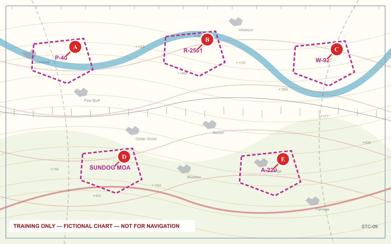
Special use airspace is printed on the sectional. Prohibited areas, restricted areas, warning areas, alert areas and military operations areas are all drawn, labelled and permanent enough to be worth learning once.
Temporary flight restrictions are not on any chart, because they did not exist when it was printed. A TFR can be created hours before you fly, over a location that was completely unrestricted when you planned the job.
Both matter. Only the second one can appear between your planning and your launch.
Special use airspace, in one table
| Prefix | Type | What it means for you |
|---|---|---|
| P | Prohibited area | Flight is not permitted. No mechanism to request entry |
| R | Restricted area | Entry requires permission from the controlling agency; hazards like artillery or guided missiles |
| W | Warning area | Over international waters, from 3 nautical miles outward. Hazards exist, permission is not required |
| A | Alert area | High-volume pilot training or unusual activity. No permission required, extra vigilance expected |
| MOA (named) | Military operations area | Separates military training from IFR traffic. No permission required |
| CFA | Controlled firing area | Not charted, because activity stops when a spotter sees an aircraft |
Two of these deserve more than a row.
Restricted areas are not always active. A restricted area has published times, and outside them it may be released to normal traffic. The chart panel gives the altitudes and the controlling agency; the times are in the chart legend or the Chart Supplement. "Restricted" does not mean "never."
The controlled firing area is the odd one out. It is the only one on the list that is not charted at all. The reason is that a CFA's activity ceases immediately when a spotter, radar or aircraft observes anything approaching. Since it never presents a hazard to a passing aircraft, there is nothing to draw. That logic is exactly why it appears on exams — the answer to "which special use airspace is not charted" is always the controlled firing area.
Military training routes: count the digits
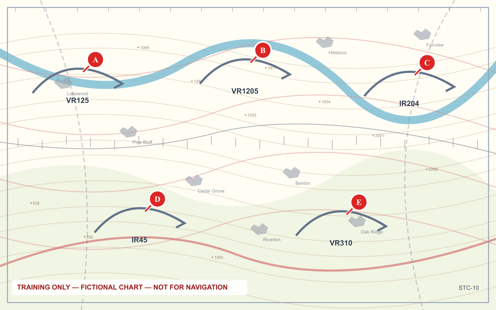
Military training routes are drawn as thin grey lines labelled IR or VR followed by a number. The prefix tells you the flight rules; the digit count tells you the altitude, and it is counterintuitive enough that it is worth stating twice:
- Four digits (VR1207, IR1206) — the route has no segment above 1,500 feet AGL
- Three digits or fewer (VR52, IR204) — the route includes segments above 1,500 feet AGL
The four-digit routes are the low ones. They are the routes that share airspace with a drone at 400 feet, and aircraft flying them may be above 250 knots at a few hundred feet. A four-digit MTR crossing your operating area is a genuine reason to post a dedicated observer looking along the route's axis.
IR routes are flown under instrument flight rules in any weather. VR routes are flown visually, in visual conditions.
Temporary flight restrictions
A TFR is a restriction on a specific volume of airspace for a specific period. The common causes:
- VIP movement. Presidential TFRs are the largest, typically a 30-nautical-mile ring with an inner 10-mile core, and they move with the protectee.
- Sporting events. Stadium TFRs cover major league baseball, NFL, NCAA Division I football and major motor races — typically a 3-nautical-mile radius up to 3,000 feet AGL, from one hour before to one hour after.
- Disasters and hazards. Wildfires, chemical spills, and other emergency response. These appear with very little notice.
- Space operations. Launch and recovery areas.
- Security. Around sensitive facilities.
The stadium one catches drone pilots more than any other, because a stadium is exactly the kind of place someone wants aerial footage of, and the restriction exists precisely when there is something to film.
What a TFR actually prohibits
A TFR is not advisory. Flying inside one without authorization is a violation of 14 CFR 91.137 through 91.145 depending on the type, and for the security-related ones the consequences escalate well beyond the FAA — intercepts, law enforcement response, and referral for criminal prosecution are all documented outcomes around presidential movements.
The practical shape of the risk for a drone operator is that TFRs are enforced by people who are already looking. A stadium TFR exists because there is a crowd and a security presence; a wildfire TFR exists because aircraft are working the fire at low level, and an incursion there can ground firefighting operations entirely.
Checking for them
There is no chart for TFRs. Check them the day of the flight:
- tfr.faa.gov — the FAA's graphical TFR list, the authoritative source
- B4UFLY — the FAA's drone-specific situational awareness app
- Your LAANC app — most surface TFR and NOTAM information alongside the authorization request
A LAANC authorization granted this morning does not mean the airspace is clear this afternoon. LAANC checks TFRs at the moment of the request, not continuously.
Hazards that are not airspace at all
The chart marks several things that restrict nothing legally but will end a flight:
- National security sensitive areas, drawn with a blue hatched boundary, requesting pilots avoid the area
- National parks and wildlife refuges, where the request is to remain 2,000 feet above the surface — and where separate National Park Service rules generally prohibit launching, landing or operating a drone from park land entirely
- Parachute jump areas, marked with a parachute symbol
- Glider and ultralight activity, both marked, both involving aircraft that are quiet and hard to see
The national park case is worth being precise about: the FAA restriction is a request, but the NPS prohibition on launching from park land is a rule with its own enforcement. Two separate bodies, two separate consequences.
Frequently asked questions
What is a TFR?
A temporary flight restriction is a short-term restriction on a defined volume of airspace, issued for events such as VIP movements, major sporting events, disaster response or space operations. TFRs do not appear on sectional charts because they are created after the chart is printed.
How do I check for TFRs before flying a drone?
Check tfr.faa.gov, the FAA's graphical TFR list, on the day of the flight. The B4UFLY app and most LAANC apps also surface TFR information. An authorization granted earlier in the day does not account for a TFR issued afterward.
What are the stadium TFR rules for drones?
Stadium TFRs typically cover a 3-nautical-mile radius up to 3,000 feet AGL around major league baseball, NFL, NCAA Division I football and major motor racing events, from one hour before until one hour after the event.
What is the difference between a restricted area and a prohibited area?
A prohibited area does not permit flight at all and has no mechanism for requesting entry. A restricted area contains hazards such as artillery or missile activity, has published active times, and may be entered with permission from the controlling agency.
Which special use airspace is not charted?
Controlled firing areas are not charted. Activity in a CFA stops immediately when a spotter, radar or aircraft detects anything approaching, so the area never presents a hazard to passing traffic and there is nothing to depict.
What does a four-digit military training route number mean?
A four-digit MTR identifier, such as VR1207, indicates the route has no segment above 1,500 feet AGL. Three digits or fewer indicates segments above 1,500 feet AGL. The four-digit routes are the low-level ones that share altitude with drone operations.
Airspace is 20 percent of the current Part 107 exam, and special use airspace questions are almost always chart-reading questions in disguise. Practice on real panels in the sectional chart trainer.
Sources
Put this guide into practice.
Take the free assessment to see how this topic fits into your current exam readiness.
Start free practice