Airspace
LAANC Authorization: How to Get Approved to Fly in Controlled Airspace
LAANC turns an airspace authorization from a 60-day paperwork exercise into a near-real-time approval. Here is how to tell from the chart whether you need one, and what to do when the answer is no.
Key takeaway
LAANC is an airspace authorization and nothing more. It gets you into Class B, C, D or surface-area E at or below the ceiling published on the UAS Facility Map grid. It does not raise your 400-foot limit, waive any other rule, or excuse you from checking NOTAMs and weather.
LAANC is the Low Altitude Authorization and Notification Capability, the FAA system that grants drone pilots near-real-time access to controlled airspace at or below 400 feet. You request it through an FAA-approved UAS Service Supplier, and if your altitude is at or under the ceiling published on the UAS Facility Map for that grid square, approval comes back in near-real time. It is currently available at 726 airports.
Most explanations of LAANC are written by the companies selling the apps, so they start at the screen where you drag a box on a map. That is the easy part. What actually catches people is one step earlier: deciding, from a sectional chart, whether you need an authorization at all. Get that wrong in the permissive direction and you have flown into controlled airspace without permission. Get it wrong the other way and you spend an afternoon requesting authorization for Class G, where nobody has any authority to give it to you.
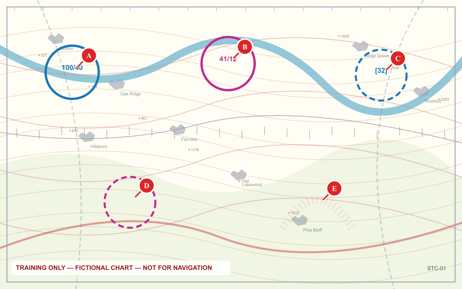
What does LAANC stand for, and what does it actually do?
LAANC stands for Low Altitude Authorization and Notification Capability. It is not an FAA app. It is a data exchange between the FAA and private companies, called UAS Service Suppliers, who build the apps you actually touch.
When you submit a request, the supplier checks it against several FAA data sets at once: UAS Facility Maps, Special Use Airspace schedules, airport and airspace class data, temporary flight restrictions and NOTAMs. If everything lines up, the authorization is issued automatically.
Two things the FAA states plainly on its LAANC page are worth committing to memory, because both come up in exam questions and in real arguments with people at airports:
- You do not need to call the tower. Unless your specific authorization says otherwise, notifying the facility before you fly is not required.
- LAANC provides airspace authorizations only. You must still check NOTAMs and weather and comply with every airspace restriction that applies.
That second point gets treated as a formality. It is not. An approved authorization tells you air traffic has no objection to a drone in that block of airspace. It says nothing about whether there is a TFR over the stadium you are filming, or whether you have the 3 statute miles of visibility that 14 CFR 107.51 demands.
When do you need LAANC authorization?
The requirement comes from one sentence of regulation. 14 CFR 107.41 reads:
No person may operate a small unmanned aircraft in Class B, Class C, or Class D airspace or within the lateral boundaries of the surface area of Class E airspace designated for an airport unless that person has prior authorization from Air Traffic Control (ATC).
Read the list carefully, because what is missing matters as much as what is there. Class G is not on it. Neither is Class E that begins at 700 or 1,200 feet AGL. The rule captures controlled airspace that reaches the ground, plus Class B, C and D generally.
That turns into a chart-reading exercise. The relevant question is not "is there an airport nearby" but "does controlled airspace touch the ground where I am standing".
| What you see on the chart | Airspace at the surface | Authorization needed? |
|---|---|---|
| Solid blue ring | Class B | Yes |
| Solid magenta ring | Class C | Yes |
| Dashed blue line | Class D | Yes |
| Dashed magenta line | Class E surface area | Yes |
| Faded magenta vignette | Class G below, Class E from 700 ft AGL | No |
| No boundary at all | Class G below, Class E from 1,200 ft AGL | No |
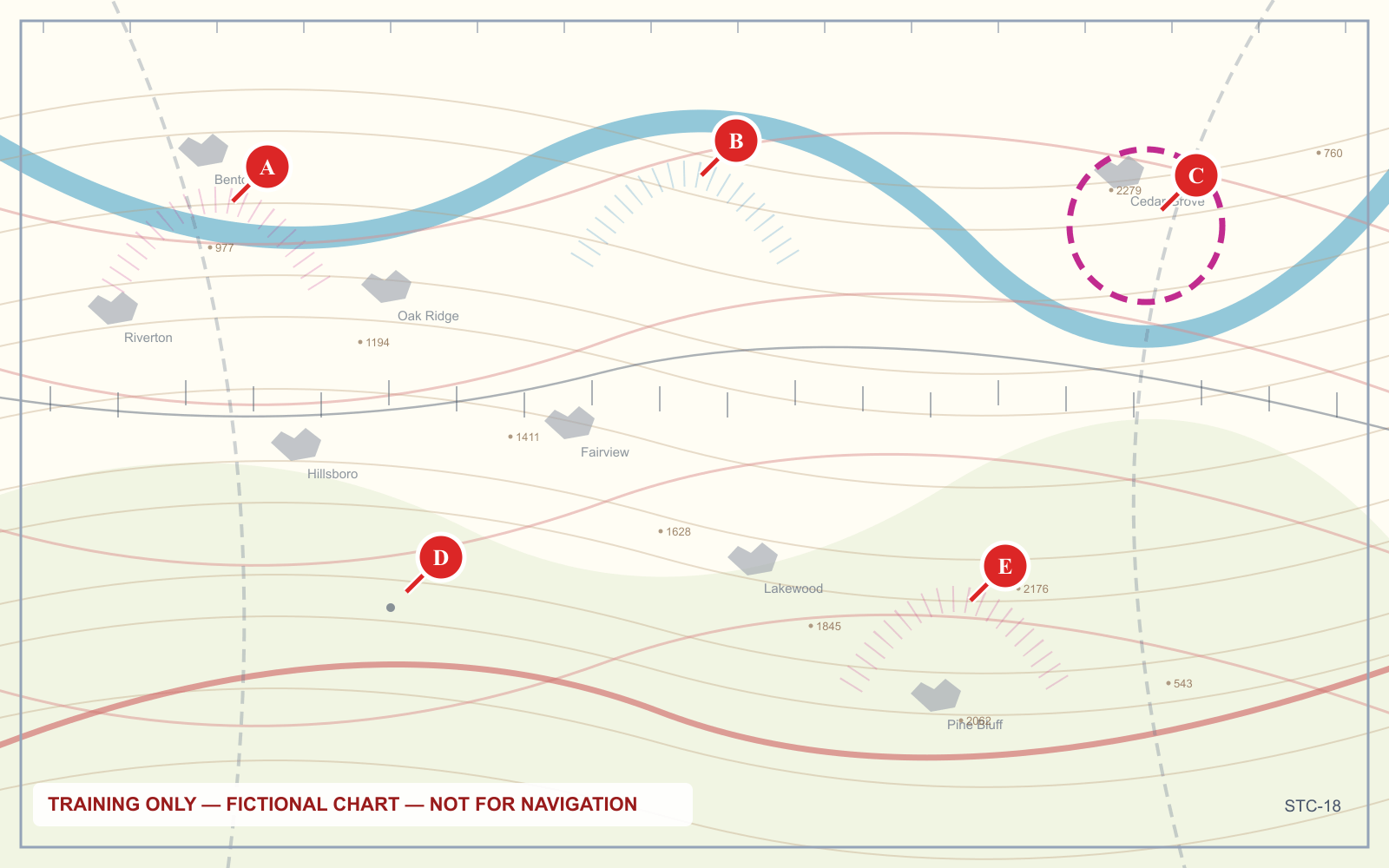
The trap is that both magenta features surround small airports and both look magenta at a glance. One requires prior ATC authorization; the other requires nothing at all. If that distinction is not automatic yet, the sectional chart symbol guide works through all of them, and the airspace classes article covers what sits above you once you are underneath a shelf.
One more case people miss. Under a Class B or Class C shelf — an outer ring that starts at some altitude above the ground rather than at the surface — you are usually in Class G. The airspace overhead is controlled, but you are not in it, and 107.41 does not apply to you at 200 feet.
What is a UAS Facility Map, and why is my ceiling zero?
The UAS Facility Map, usually shortened to UASFM, is the grid you see overlaid on a LAANC app. The FAA describes it as showing "the maximum altitudes around airports where the FAA may authorize part 107 UAS operations without additional safety analysis."
The grid squares carry a ceiling in feet AGL. Request at or below that number and the system can approve you automatically. Request above it and a human has to get involved.
Two things about these maps are widely misunderstood.
The map does not authorize anything. The FAA is emphatic here: the maps are informational only, and operators must still apply through LAANC or the FAADroneZone. Seeing a friendly number in your grid square and launching is not compliance. The number tells you what would probably be approved, not that it has been.
A zero-foot grid is not a permanent closure. Grids close to a runway threshold are often published at 0 feet, which stops the automatic path cold. It does not stop the manual one. The FAA states that certificated remote pilots can use LAANC to obtain authorization above UASFM grid values "including 0' grids" by submitting a further coordination request. The answer may still be no, but the door is not locked.
How to get LAANC approval, step by step
There are three routes into controlled airspace, and choosing the wrong one is how people end up waiting two months for something they could have had the same morning.
| Route | Use it when | Lead time | Who can use it |
|---|---|---|---|
| Near-real-time LAANC | Your altitude is at or below the UASFM grid ceiling | Apply on the day you fly; approval typically near-real time | Part 107 and recreational flyers |
| Further coordination via LAANC | You need to fly above the grid ceiling, still at or below 400 ft | Submit up to 90 days ahead, and at least 72 hours before the start time | Part 107 only |
| FAADroneZone manual request | The airport is not LAANC-enabled, or you also need a waiver | Submit at least 60 days before the operation | Part 107 only |
For the near-real-time path, the FAA's instructions are four steps: apply on the date you wish to fly, select the exact time, altitude and location, keep the altitude at or below the UASFM value, and receive approval typically in near-real time. Your supplier's app shows the grid ceiling automatically, so the third step usually takes care of itself.
Further coordination is not automated. The request goes to the Air Traffic Manager who runs that airspace, and a person reads it. That is why the 72-hour minimum exists, and why a vague request does badly. Give the manager specific times, a specific altitude and a reason.
Access to any of this requires two things first: your drone must be registered, and you must hold a remote pilot certificate. Recreational flyers register the aircraft and pass TRUST instead, and they get the near-real-time path only.
Which providers are approved, and does it cost anything?
LAANC access comes only through companies the FAA has approved as UAS Service Suppliers. On the FAA's list at the time of writing, twelve offer publicly available services: AirMatrix, Airspace Link, Aloft, AstraUTM, AutoPylot, Avision, eTT Aviation, Flightloop, FlightReady, Flyfreely, UASidekick and Wing. Several others hold approval but do not offer the service publicly.
That list changes as suppliers are approved or withdraw, and the FAA's table marks which capabilities each one supports, so check the source rather than a blog post before committing to an app. The FAA also states its listing does not constitute endorsement.
There is no FAA fee for a LAANC authorization. The suppliers offering public services provide the request at no cost, though several sell paid tiers around it for fleet management, logging and team features.
What this means when you are actually working
The exam version of this topic is a chart question. The working version is a scheduling problem, and it changes how you quote jobs.
If a client wants roof inspection footage at 120 feet in a Class D grid published at 200, that is a same-morning job. If the same client wants a 350-foot orbit over a site sitting in a 100-foot grid, that is a job you cannot accept for tomorrow. It needs a further coordination request with a 72-hour minimum, and a realistic conversation about whether the airport will say yes at all. So check the grid before you price the work, not after. A 400-foot grid and a 0-foot grid two blocks away are the difference between an hour of flying and three days of waiting on an air traffic manager.
Keep the boundary clear between an authorization and a waiver. They are separate instruments with separate applications, and if your operation needs both, the FAA requires you to apply for both through the FAADroneZone. A LAANC approval does not carry a waiver along with it.
What to do when LAANC says no
A denial is not the end of the process. Work through it in this order.
- Check whether you actually need the altitude. Dropping from 250 feet to the published 200 turns a coordination request back into an instant approval. Most jobs survive the change.
- Submit a further coordination request. This is the intended path for anything above the grid value, up to 400 feet, and it works even where the grid reads zero.
- Read the guidance on a denial. The FAA notes that facilities can provide additional guidance on denied further coordination requests, which lets you adjust the operation and resubmit rather than starting over blind.
- Consider a waiver, if the obstacle is a rule rather than the airspace. Section 107.41 is on the list of waivable regulations at 14 CFR 107.205, and 14 CFR 107.200 sets out the standard: you must show the operation can be conducted safely under the terms of the certificate. A waiver is for recurring or unusual operations, not for one Tuesday afternoon.
What you should not do is treat a denial as advisory. Prior ATC authorization is a condition of the flight, not a suggestion, and operating without it exposes you to FAA enforcement ranging from counseling through certificate suspension or revocation and civil penalty.
Frequently asked questions
What happens if you fly without LAANC?
Flying in Class B, C, D or surface-area Class E without prior ATC authorization violates 14 CFR 107.41. Enforcement varies with the circumstances and your history, from counseling and remedial training under the FAA Compliance Program through to certificate suspension or revocation and civil penalties. Airport operators and law enforcement do report drone activity near runways.
Is LAANC approval free?
Yes. The FAA does not charge for an airspace authorization, and the UAS Service Suppliers listed as providing public LAANC services offer the request at no cost. Some suppliers sell paid subscription tiers built around the free authorization, adding fleet management, crew logging or airspace planning features you are not required to buy.
How long does it take to get a LAANC authorization?
A near-real-time request, at or below the UAS Facility Map grid ceiling, is typically approved in near-real time on the day you apply. A further coordination request to fly above the grid ceiling must be submitted at least 72 hours before your start time and is reviewed manually by an air traffic manager. A manual FAADroneZone request needs 60 days.
Which app is best for LAANC approval?
The FAA states explicitly that listing a supplier is not an endorsement, so there is no official best. The practical test is whether the supplier is on the FAA's current approved list and supports the capability you need, since not every supplier offers further coordination or recreational requests. Check the FAA's table rather than app store rankings.
Do I need LAANC to fly in Class G airspace?
No. Section 107.41 covers Class B, Class C, Class D and the surface area of Class E designated for an airport. Class G is uncontrolled, so no authorization exists to request. The same applies beneath a Class E floor charted at 700 or 1,200 feet AGL, where you are in Class G at drone altitudes.
Does LAANC let me fly above 400 feet?
No. LAANC only ever grants access to controlled airspace at or below 400 feet, and a further coordination request raises you toward that ceiling, not past it. The 400-foot limit in 14 CFR 107.51 is a separate operating limitation, and exceeding it requires a waiver rather than an airspace authorization.
Reading the boundary correctly is the whole skill here, and it is faster to drill than to read about. The sectional chart trainer gives you annotated panels and asks you to classify the point, which is exactly the decision you make before every flight near an airport.
Sources
- FAA — UAS Data Exchange (LAANC)
- FAA — Part 107 Airspace Authorizations
- FAA — UAS Facility Maps
- 14 CFR 107.41 — Operation in certain airspace
- 14 CFR 107.200 — Waiver policy and requirements
- 14 CFR 107.205 — List of regulations subject to waiver
- 14 CFR 107.51 — Operating limitations for small unmanned aircraft
Put this guide into practice.
Take the free assessment to see how this topic fits into your current exam readiness.
Start free practice