Airspace
MSL vs AGL: The Two Altitudes on Every Chart, and Which One the 400-Foot Rule Uses
Every altitude you read as a remote pilot is measured from one of two places: sea level, or the dirt under your feet. Mixing them up is the most common chart mistake on the Part 107 exam.
Key takeaway
The 400-foot Part 107 ceiling is AGL. Almost every altitude printed on a sectional chart is MSL. Field elevation is the number that converts between them.
MSL means mean sea level: height measured from the sea, no matter what the ground below you is doing. AGL means above ground level: height measured from the dirt directly beneath the aircraft. The Part 107 ceiling of 400 feet is AGL. Almost every altitude printed on a sectional chart is MSL. The difference between them is the elevation of the ground you are standing on.
That last sentence is the whole topic, and it is the part most explanations skip. AGL and MSL are not two competing ways of saying the same thing. They are the same measurement taken from two different floors, and the gap between those floors changes every time you drive to a new job site. A remote pilot who never converts between them will be fine in Florida and illegal in Colorado without ever noticing the rule changed.
What does AGL mean in aviation, and what does MSL mean?
The FAA gives these two references formal names in the Pilot's Handbook of Aeronautical Knowledge. True altitude is the vertical distance of the aircraft above mean sea level. Absolute altitude is the vertical distance of the aircraft above the terrain. In everyday use those become MSL and AGL.
Mean sea level is a fixed datum. It does not move when you drive inland, which is exactly why charts use it. Every airspace boundary, every obstruction top, every terrain figure can be printed once and read the same way by an airliner at 30,000 feet and a Cessna at 3,000, because they all share one floor.
Ground level is not fixed. It is whatever is underneath the aircraft at this instant, and it changes as you fly across a ridge or out over a valley. That is precisely why the FAA wrote the drone rule in AGL: the hazard a small drone creates is a function of how far it is above the things and people below it, not how far it is above the ocean.
Which altitude does the 400-foot rule use?
AGL, and the regulation says so directly. Under 14 CFR 107.51(b), the altitude of the small unmanned aircraft "cannot be higher than 400 feet above ground level," unless the aircraft is flown within a 400-foot radius of a structure and does not fly higher than 400 feet above that structure's immediate uppermost limit.
Read the exception carefully, because it is also written in AGL and people misread it as a blanket permission. It does not raise your ceiling across the site. It raises the ceiling only inside a 400-foot radius of the structure, and only to 400 feet above the top of that structure. Step outside the radius and you are back to 400 feet above the ground beneath you. There is more on how that plays out in practice in our guide to how high a drone can legally fly.
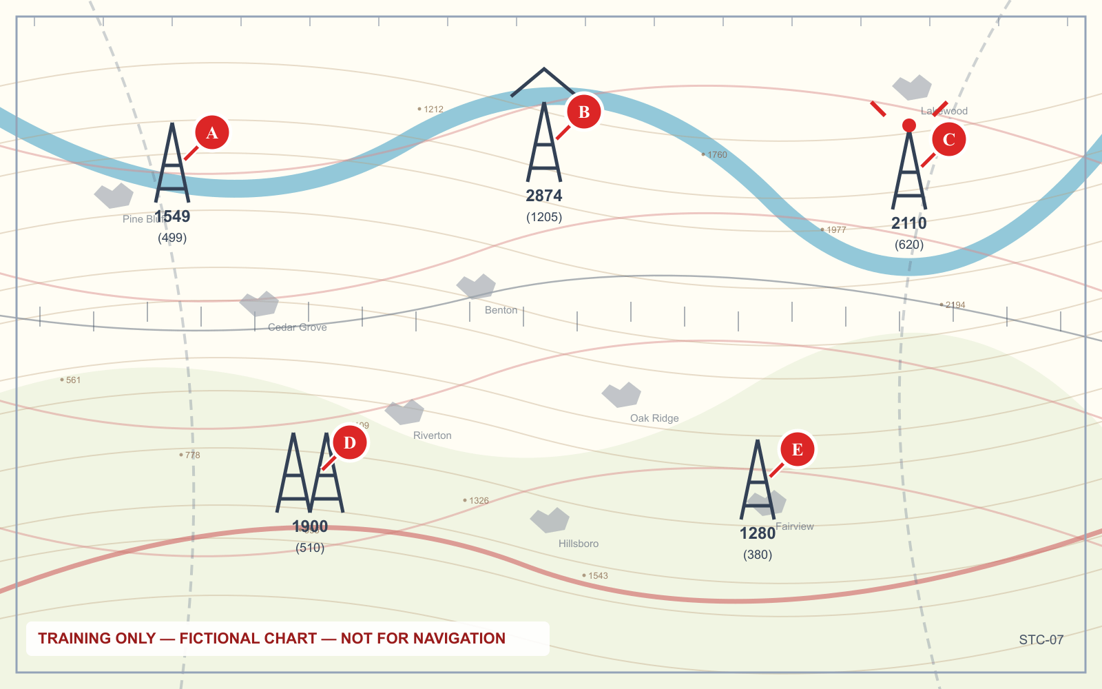
Take tower B in the figure above. It tops out at 2,874 feet MSL and stands 1,205 feet tall, so the ground at its base is at 1,669 feet MSL. Standing there, your ordinary ceiling is 400 feet AGL, which is 2,069 feet MSL. Working the tower under the structure exception, your ceiling is 3,274 feet MSL. Same field, same pilot, two legal ceilings 1,205 feet apart, and neither number is printed anywhere on the chart.
MSL vs AGL on sectional charts: which numbers are which
A sectional mixes both references on the same sheet, without labeling them. You are expected to know which convention applies to which symbol.
| What you are reading | Reference | How it appears |
|---|---|---|
| Class B, C and D floors and ceilings | MSL | Hundreds of feet, ceiling over floor, e.g. 100 / 30 = 10,000 over 3,000 MSL |
| Class D ceiling | MSL | Bracketed, e.g. [25] = 2,500 MSL |
| Class E floor shown by a faded magenta vignette | AGL | Not a number at all — the shading means 700 feet AGL |
| Class E floor where none is charted, outside a vignette | AGL | 1,200 feet AGL by default |
Class E floor printed in a box, e.g. 3500 MSL | MSL | Written out, and the chart says MSL |
| Obstruction: the bold top figure | MSL | Height of the top above sea level |
| Obstruction: the bracketed figure below it | AGL | Height of the structure itself |
| Maximum elevation figures, the large sparse digits | MSL | Thousands and hundreds, covering the whole quadrangle |
| Airport elevation in the data block | MSL | A plain number after the airport name |
| Mode C veil ceiling | MSL | 10,000 feet MSL, a fixed lid |
The pattern is worth naming: numbers are MSL, shading is AGL. Where a sectional prints a figure, assume sea level unless it says otherwise. Where a sectional uses color to tell you a floor, that floor is measured from the ground. Our walkthrough of the sectional symbols that matter covers the rest of the legend.
The awkward case is Class E, which is why it gets three rows above. Class E floors are the one airspace boundary routinely expressed in AGL, because they are defined relative to the airports they protect rather than relative to the sea. Everything else in the airspace classes is MSL.
How do you convert MSL to AGL?
One subtraction, and one number you have to go and find.
AGL = MSL − ground elevation · MSL = AGL + ground elevation
The ground elevation is the elevation of the terrain beneath the aircraft, not the elevation of the nearest airport, although at a launch site near a field those are usually close enough to work with. You can get it from the airport elevation in the chart data block, from the obstruction arithmetic shown above, from the terrain contours, or from the Chart Supplement entry.
Work an example. You are launching near a field at 1,669 feet MSL. Overhead, a Class B shelf has a charted floor of 3,000 MSL. Is your 400-foot flight underneath it?
Convert the floor: 3,000 − 1,669 = 1,331 feet AGL. Your ceiling is 400 feet AGL. You have 931 feet of clearance and you are in the airspace beneath the shelf, not inside the Class B.
Now move to a site where the ground is at 2,800 feet MSL under the same 3,000-foot shelf. The floor is now only 200 feet above the ground. Your 400-foot ceiling would put you 200 feet inside Class B. The chart did not change. The dirt did.
Why weather products mix the two as well
The charts are consistent. Weather is not, and this catches people who have already mastered the chart conventions.
| Product | Altitude reference |
|---|---|
| METAR sky condition and ceiling | AGL, above the reporting station's elevation |
| TAF sky condition | AGL, above the airport |
| PIREP altitudes, including cloud bases and tops | MSL |
| Winds and temperatures aloft forecasts | MSL |
| AIRMET and SIGMET altitudes | MSL |
| Class A airspace, above 18,000 feet | Pressure altitude, set to 29.92 |
A METAR reading BKN008 means a broken layer at 800 feet above that airport. If you are launching from a site 300 feet higher than the field, the layer is roughly 500 feet above you, and 14 CFR 107.51(d) requires you to stay 500 feet below it. That flight is marginal in a way the raw report does not advertise.
PIREPs run the other way. A pilot reporting cloud bases at 4,500 is reporting MSL, and at a site with 1,669 feet of ground elevation that is 2,831 feet above you. Our field-by-field PIREP guide covers where that bites.
What your controller screen is actually showing
Neither one, strictly. Almost every consumer drone displays height above the takeoff point, computed from a barometric sensor that was zeroed the moment you powered up on the ground.
That is a third reference, and on flat ground it happens to equal AGL closely enough that nobody notices. It stops being AGL the moment the terrain under the aircraft is not the terrain you launched from. Launch from the top of a bluff, fly out over the river, and your screen still reads 380 feet while the aircraft is 500 feet above the water. Launch from the bottom of the same bluff and fly toward the rim, and your screen reads 380 while the aircraft is 100 feet above the ground ahead of it.
The regulation is written against the ground beneath the aircraft. Your screen is written against the ground beneath your feet at power-up. When those two differ, the screen is not your defense.
What this means when you are actually working
Three habits close the gap, and none of them take long.
Write down the site elevation before you leave. One number, on the flight plan, next to the METAR. Everything else in the preflight either subtracts from it or adds to it.
Convert every MSL boundary into AGL once, at the site. Class B and C shelves, Class D ceilings, the Mode C veil lid. Do the arithmetic while you are sitting in the truck, not while the aircraft is in the air and something is converging.
Survey the terrain you intend to fly over, not just the terrain you stand on. If the job runs along a ridge, down a quarry face, or out over a levee, the ground beneath the aircraft is moving and your 400-foot allowance is moving with it. Plan the descent, or plan a second launch point.
How the exam asks about it
Rarely as a definition. The Unmanned Aircraft General knowledge test puts airspace at 20 percent of the question pool under the blueprint effective 29 September 2025, and altitude reference is woven into those questions rather than tested on its own. Expect these shapes:
- A chart excerpt plus a proposed altitude. You are given an airport elevation and an airspace floor in MSL, and asked whether a flight at some AGL altitude is legal. The work is one subtraction.
- An obstruction question. You are given a tower with both figures and asked for the elevation of the ground, or for the highest altitude you may fly within 400 feet of it.
- A distractor built on the wrong reference. The options include the number you get by forgetting to subtract field elevation. It is always there, and it is always plausible.
Frequently asked questions
Do pilots use MSL or AGL?
Both, for different purposes. Manned pilots fly and report altitudes in MSL because the altimeter reads MSL when set to the local altimeter setting, and because airspace is charted in MSL. AGL is used for traffic pattern altitudes, cloud ceilings in a METAR, and the Part 107 drone ceiling, where what matters is separation from the ground rather than from the sea.
Is MSL higher than AGL?
Almost always, and by exactly the elevation of the ground beneath you. A drone 400 feet AGL over terrain at 1,669 feet MSL is at 2,069 feet MSL. The two numbers are only equal where the ground is at sea level, and MSL is smaller than AGL only over ground that sits below sea level, such as Death Valley.
How do I convert MSL to AGL?
Subtract the elevation of the ground beneath the aircraft from the MSL figure. To go the other way, add it. The ground elevation comes from the airport elevation in the sectional data block, from an obstruction's two figures subtracted from each other, or from the terrain contours. There is no other step and no correction factor.
Is Class D airspace AGL or MSL?
The ceiling is MSL. On a sectional it appears as a bracketed figure in hundreds of feet, so [25] means the Class D tops out at 2,500 feet MSL. The floor is the surface. To know how much room you have beneath the ceiling, subtract the field elevation, though at 400 feet AGL a drone is comfortably inside Class D from top to bottom anyway.
Does the altimeter show MSL or AGL?
MSL, when it is set to the current local altimeter setting. A barometric altimeter has no idea what the terrain is doing; it measures pressure and converts it to a height above a sea level datum. The instrument that reads AGL directly is a radar altimeter, which measures the distance to the surface and is not fitted to small drones.
Is the 400-foot structure exception measured in MSL?
No. It is 400 feet above the structure's uppermost limit, which is an AGL measurement taken from the top of the structure rather than from the ground. You can express the resulting ceiling in MSL by adding 400 to the obstruction's charted top figure, and that is a useful cross-check, but the rule itself is written above the structure.
Reading both references off a chart under time pressure is a trainable skill. Work through annotated panels on the sectional chart practice tool.
Sources
Put this guide into practice.
Take the free assessment to see how this topic fits into your current exam readiness.
Start free practice