Weather
How to Read a PIREP: The Pilot Report, Field by Field
A PIREP is the only weather product written by a human who was actually there. Here is how to decode one, and an honest look at what it tells you at 400 feet.
Key takeaway
A PIREP reports altitudes in MSL, not AGL. Before you compare a reported cloud base to your planned altitude, convert one of them.
A PIREP (pilot report) is a weather observation filed by a pilot who actually flew through the conditions. It is coded in slash-delimited fields: UA for routine or UUA for urgent, then /OV location, /TM time, /FL altitude and /TP aircraft type, which are mandatory, followed by optional fields for sky, weather, temperature, wind, turbulence and icing.
Every other weather product you use is a machine reading or a computer forecast. A METAR is an automated station reporting what it senses at one point on the ground. A TAF is a prediction. A PIREP is the only product where a person was in the air, saw the thing, and said so. That makes it the most useful product on the list and the most inconsistently available, because it exists only when somebody bothers to file one.
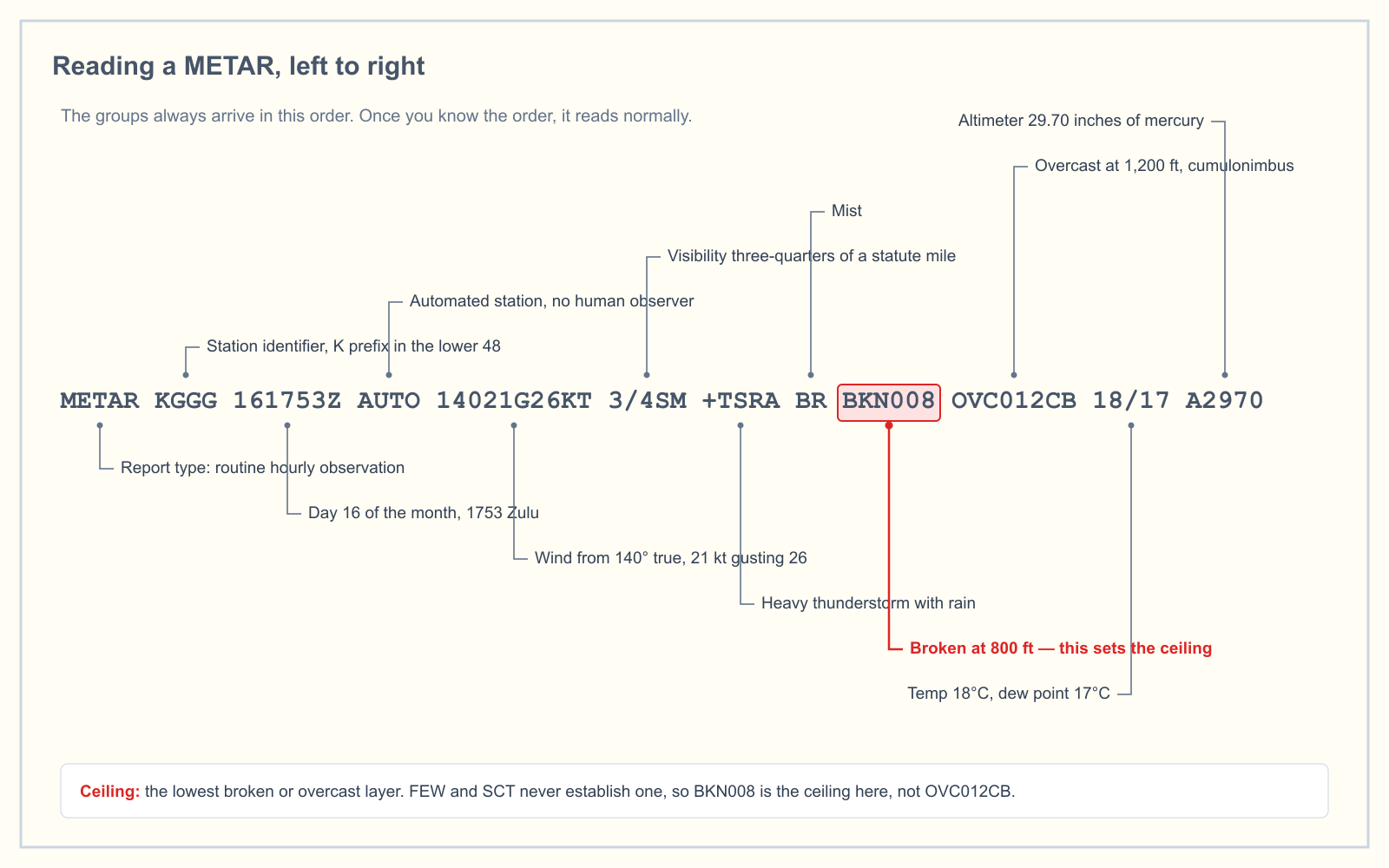
What is a PIREP, and why do pilots file them?
The FAA actively solicits pilot reports rather than waiting for them. Under FAA Order JO 7110.10, Chapter 8, flight service specialists must request PIREPs whenever ceilings are at or below 5,000 feet, whenever visibility on the surface or aloft is five miles or less, and whenever thunderstorms, moderate or greater turbulence, light or greater icing, or wind shear are reported or forecast.
Read that list again with a drone pilot's eyes. Those are not high-altitude cruise conditions. Ceilings at 5,000 feet and visibility under five miles are exactly the marginal days when you are standing in a field deciding whether to launch.
The reason the FAA wants them is that automated observations miss things. An ASOS at the field can tell you the ceiling above the sensor. It cannot tell you that the layer is ragged two miles east, that there is a shelf of cloud sitting on the ridge, or that the air below 4,000 feet is rough enough to be uncomfortable. A pilot can.
UA or UUA: what makes a report urgent?
The first field is the message type, and it is the fastest read in the whole report. Chapter 8 lists exactly which phenomena force the urgent classification:
| Urgent (UUA) is required for | Notes |
|---|---|
| Tornadoes, funnel clouds or waterspouts | Spelled out in the remarks as well |
| Severe or extreme turbulence | Includes clear air turbulence |
| Severe icing | Temperature must also be reported |
| Hail | Size given in quarter-inch increments in remarks |
| Low-level wind shear | Urgent if airspeed fluctuations of 10 knots or more are reported, or if no fluctuation figure is given at all |
| Volcanic eruption, ash clouds, or sulfur gases in the cabin | Sulfur smell with confirmed no ash is routine |
Everything else is routine, coded UA. There is also a catch-all: a specialist may classify any other reported phenomenon as urgent if they judge it hazardous or potentially hazardous to flight operations.
Note where wind shear sits. Low-level wind shear is defined as shear within 2,000 feet of the surface, and the default classification when the pilot does not quantify the airspeed loss is urgent. The FAA errs toward urgent on that one specifically for the safety of light aircraft, which is a reasonable way to think about your own aircraft too.
The fields, and which ones are mandatory
The message type plus four fields are required on every PIREP. The rest appear only when the pilot reported something in them, which is why no two PIREPs look alike.
| Field | Meaning | Required? |
|---|---|---|
| UA / UUA | Routine or urgent | Yes |
| /OV | Location, referenced to a NAVAID or airport | Yes |
| /TM | Time the phenomenon was encountered, four digits UTC | Yes |
| /FL | Altitude in hundreds of feet MSL where it was first encountered | Yes |
| /TP | Aircraft type | Yes |
| /SK | Sky condition: cloud bases, tops and coverage | Optional |
| /WX | Flight visibility and weather | Optional |
| /TA | Air temperature in Celsius, M prefix for negative | Optional |
| /WV | Wind direction and speed | Optional |
| /TB | Turbulence: intensity, type, altitude | Optional |
| /IC | Icing: intensity, type, altitude | Optional |
| /RM | Remarks | Optional |
Two conditional rules are worth knowing because the exam likes them. Turbulence and icing reports must always include the aircraft type, since moderate turbulence in a Cessna 172 and moderate turbulence in a Boeing 737 are not the same air. And when icing is reported, the temperature field must be filled in too.
How to read the /OV location field
This is the field people get stuck on, and it has three valid forms.
A bare identifier. /OV KJFK means over or very near that airport or NAVAID.
Identifier, radial, distance. /OV KJFK107080 is the common one. Read it in three chunks: the identifier, then three digits of radial, then three digits of distance in nautical miles. So that is the 107 degree radial from JFK, 80 nautical miles out. The radial is the bearing from the station, not toward it.
A route segment. Two fixes separated by a hyphen: /OV KSTL-KMKC means the condition was encountered somewhere along that leg. With radials and distances appended it narrows down: /OV KSTL090030-KMKC045015.
There is a fourth form, latitude and longitude, and it contains a detail that almost no PIREP explainer mentions. Chapter 8 permits latitude and longitude for crewed aircraft over water where a NAVAID reference is impractical, and separately for UAV or UAS flying anywhere in the world. Uncrewed aircraft are written into the PIREP format explicitly. You are not a bystander to this system.
A PIREP decoded, left to right
Here is a report that would actually change a drone pilot's morning:
UA /OV KFDK180015 /TM 1345 /FL025 /TP C172
/SK OVC022-TOPUNKN /WX FV04SM BR /TA 09
/WV 22012KT /TB LGT BLO 040 /RM DURD
| Field | Reads as |
|---|---|
UA | Routine report, nothing on the urgent list |
/OV KFDK180015 | On the 180 radial from Frederick, 15 nautical miles south |
/TM 1345 | Encountered at 1345 UTC |
/FL025 | At 2,500 feet MSL |
/TP C172 | From a Cessna 172 |
/SK OVC022-TOPUNKN | Overcast with a base at 2,200 feet MSL, tops unknown |
/WX FV04SM BR | Four statute miles flight visibility in mist |
/TA 09 | Nine degrees Celsius |
/WV 22012KT | Wind from 220 degrees at 12 knots |
/TB LGT BLO 040 | Light turbulence below 4,000 feet |
/RM DURD | Observed during descent |
The pilot flew into it, wrote down what they found, and moved on. Now you know the layer is solid rather than broken, that it has no reported top, that the air underneath is light chop rather than smooth, and that a human confirmed four miles of visibility rather than a sensor inferring it.
The altitudes are MSL, and this is where drone pilots go wrong
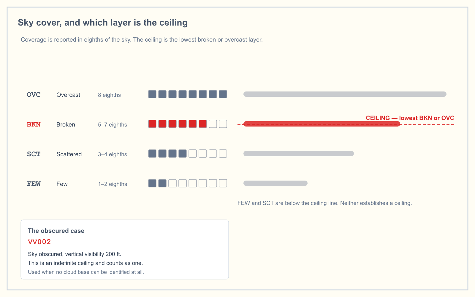
Both /FL and the heights in /SK are in feet above mean sea level. You fly and think in feet above ground level, because 14 CFR 107.51 caps you at 400 feet AGL. Those are different references and you cannot compare them directly.
Work the example above. The reported base is 2,200 feet MSL. If the field elevation where you are standing is 300 feet, the cloud base is roughly 1,900 feet above you. Your ceiling at 400 feet AGL leaves about 1,500 feet of vertical separation, comfortably clear of the 500 feet below a cloud that 107.51 requires. Change the field elevation to 1,400 feet and that same report puts the base 800 feet above the ground, and now a flight at 400 feet AGL has only 400 feet of clearance. Same PIREP, illegal flight.
Subtract field elevation from the reported height before you compare anything. That single conversion is the most common way this product gets misread.
The honest limitation: PIREPs come from far above where you fly
Most competitor pages will not tell you this, so here it is plainly. The overwhelming majority of PIREPs are filed from cruise, climb or approach at altitudes thousands of feet above your operating ceiling. A report of moderate turbulence at 12,000 feet tells you approximately nothing about the air at 400 feet AGL.
What a PIREP genuinely gives a remote pilot is narrower than the enthusiast sites suggest, but it is real:
- Cloud bases in the
/SKfield. This is the number that feeds directly into your 107.51 cloud clearance decision, and it is a human observation rather than a laser ceilometer's guess. - Flight visibility in
/WX. A pilot's assessment of how far they could actually see, which is the same judgment 107.51 asks you to make from the control station. - Anything tagged
BLO./TB LGT BLO 040means the turbulence extends down through the layer you fly in. Reports during climb or descent, markedDURCorDURDin remarks, sample the low levels on the way past. - Confirmation or contradiction of the METAR. When the automated report says one thing and a pilot who was there says another, that disagreement is information.
Use it as corroborating evidence for the preflight weather assessment 107.49(a)(1) requires, not as your primary source. Your primary sources remain the METAR and the TAF.
Where to get them, and how long they are good for
PIREPs are published on aviationweather.gov, on the graphical forecast tool and in most flight planning apps. They are also read out by flight service on request.
A PIREP has no validity period, and this is a genuine conceptual difference from the other products you study. A TAF is valid for a stated window. A METAR is issued on a schedule. A PIREP is a single observation, at one place, at one moment, by one aircraft. The /TM field is the entire story of its currency. A report from 40 minutes ago on a fast-moving frontal day may already be wrong; a report from two hours ago in a stagnant airmass may still be perfectly good. Judge it by what the weather is doing, not by a clock.
How PIREPs feed AIRMETs and SIGMETs
Urgent PIREPs are relayed immediately and used to evaluate whether a SIGMET should be issued or amended. This is the part the knowledge test likes, because it establishes direction: the pilot report is an input to the hazard advisory, not an output of it. A pilot encounters severe icing, files a UUA, and that report can trigger the SIGMET that warns everybody else.
That relationship also explains a gap you will notice in practice. An AIRMET or SIGMET covers a large area for a stated period. A PIREP is one point at one time. When the two disagree, they are not really in conflict, they are answering different questions at different resolutions.
Weather sits inside the Weather and Loading area of the knowledge test, which is 5 percent of the Unmanned Aircraft General blueprint effective 29 September 2025. It is a small slice, so expect PIREP questions to be straightforward recall: what the acronym means, which fields are mandatory, what makes a report urgent, and occasionally a short decode.
What this means when you are actually working
You have a 9 a.m. mapping flight and the METAR is marginal. Here is where a PIREP earns its place in the routine, and where it does not.
Check for PIREPs after you have read the METAR and TAF, not before. You are looking for two specific things: a human confirmation of the cloud base, and anything reported below 4,000 feet or during a climb or descent. If neither exists, you have lost thirty seconds and nothing else. If a Cessna descending into the field twenty minutes ago reported the base 400 feet lower than the automated observation, you have just learned something the sensor could not tell you, and your preflight assessment is better for it.
What you should not do is delay a decision waiting for a PIREP to appear. In quiet airspace on a quiet morning, nobody is flying, so nobody is filing. Absence of PIREPs is absence of traffic, not absence of weather.
Frequently asked questions
What does PIREP stand for?
PIREP stands for pilot report, a weather observation transmitted by a pilot describing conditions actually encountered in flight. Reports are coded as UA for routine or UUA for urgent, and the FAA solicits them through flight service, particularly when ceilings are at or below 5,000 feet or visibility is five miles or less.
What is the difference between a UA and a UUA PIREP?
UA is a routine pilot report. UUA is urgent, and is required for tornadoes, funnel clouds or waterspouts, severe or extreme turbulence, severe icing, hail, low-level wind shear, and volcanic ash. Urgent reports are relayed immediately and are used to evaluate whether a SIGMET should be issued or amended.
How do you read the location in a PIREP?
The /OV field gives a NAVAID or airport identifier, optionally followed by three digits of radial and three digits of distance in nautical miles. So /OV KJFK107080 is the 107 degree radial from JFK, 80 nautical miles out. Two identifiers separated by a hyphen describe a route segment instead.
How long is a PIREP valid?
A PIREP has no formal validity period. It is a single observation at one location and one moment, and the /TM field is the only guide to how current it is. Judge its usefulness by how quickly the weather is changing, not by a fixed expiry. Fast-moving systems make reports stale within the hour.
Are PIREP altitudes AGL or MSL?
MSL. Both the /FL field and the cloud heights in /SK are reported in hundreds of feet above mean sea level. Since Part 107 limits you to 400 feet AGL, you must subtract the field elevation from a reported cloud base before comparing it to your planned altitude.
Can a drone pilot file a PIREP?
FAA Order JO 7110.10 explicitly contemplates uncrewed aircraft in the /OV field, permitting UAV or UAS to report position as latitude and longitude anywhere in the world, though not in US coastal waters where a NAVAID reference is practical. In practice, filing is rare from 400 feet, and submission through aviationweather.gov requires a registered account.
Weather is only 5 percent of the exam, but it is the area candidates most often skip and then lose easy marks on. The free readiness assessment mixes weather questions in with the other four knowledge areas so you can see where you actually stand, and the METAR practice trainer drills the decoding in raw report format.
Sources
- FAA Order JO 7110.10, Flight Services, Chapter 8 — FAA Weather Services
- AIM 7-1-18 — Pilot Weather Reports (PIREPs)
- 14 CFR 107.49 — Preflight familiarization, inspection, and actions for aircraft operation
- 14 CFR 107.51 — Operating limitations for small unmanned aircraft
- Aviation Weather Center — PIREP submission and display
- FAA Airman Certification Standards
Put this guide into practice.
Take the free assessment to see how this topic fits into your current exam readiness.
Start free practice