Weather
ATIS vs AWOS vs ASOS: The Three Airport Weather Broadcasts, Explained
All three broadcast weather at an airport, and all three are on your sectional if you know where to look. The difference is who assembles the message and how often it changes.
Key takeaway
ATIS is a recorded human broadcast updated hourly; AWOS and ASOS are automated and update every minute. The automated stations generate the METAR you already know how to read, so the voice broadcast and the coded report are the same observation.
All three are weather broadcasts at an airport, and the difference is who assembles the message. ATIS is a recording made by a person at a towered field, updated hourly and whenever something changes. AWOS and ASOS are automated stations with no human in the loop, broadcasting a 20 to 30 second message updated every minute. ASOS is the more capable of the two automated systems.
Most explanations of these acronyms stop at the definitions, which is the least useful part. What matters to a remote pilot is that the automated station's output is the METAR. The voice on the radio and the coded report on your phone are the same observation in two formats, from the same sensors in the same field. Once you see that, the topic collapses into something simpler than the acronyms suggest.
What do ATIS, AWOS and ASOS stand for?
| Acronym | Full name | Assembled by |
|---|---|---|
| ATIS | Automatic Terminal Information Service | A person, recorded |
| AWOS | Automated Weather Observing System | Sensors and a voice synthesizer |
| ASOS | Automated Surface Observing System | Sensors and a voice synthesizer |
The word doing the work is Automatic versus Automated. ATIS is automatic only in its playback: a controller records a message and the system repeats it on a loop, so nobody has to read the same numbers to forty aircraft. AWOS and ASOS are automated end to end. Sensors measure, a processor assembles, a synthesized voice reads it out.
That distinction predicts almost everything else about the three: what they contain, how often they change, and how much you should trust them.
What is ATIS, and what is in the broadcast?
Per AIM 4-1-13, ATIS is the continuous broadcast of recorded noncontrol information in selected high activity terminal areas. It exists to relieve frequency congestion, so a controller handles only what is actually about your aircraft.
ATIS carries more than weather. You also get the approach in use, the active runway, NOTAMs affecting the field, taxiway closures, bird activity, construction. It is the whole operational picture of the airport, which is why it only exists where there is someone to assemble it.
The update rule is the part worth memorizing. ATIS must be updated on receipt of any official hourly or special weather observation, and a new recording is also made when other pertinent data changes, such as a runway change. So the floor is hourly, and it updates sooner when something moves.
Each recording is identified by a letter of the phonetic alphabet, advancing with every message. That letter is how a controller checks you have current information. If you have Juliet and they are on Kilo, something changed and you missed it.
ATIS is engineered for a protected service volume of normally 20 to 60 NM from the site and a maximum altitude of 25,000 feet AGL. From a launch site a few miles out, you will usually hear it on the ground.
What is AWOS, and what are the AWOS levels?
AWOS is a sensor suite plus a transmitter, broadcasting local minute-by-minute weather directly to pilots. The catch is that AWOS comes in levels, and the level tells you what the station can and cannot measure. AIM 7-1-10 lists them:
| Level | Reports |
|---|---|
| AWOS-A | Altimeter setting only |
| AWOS-AV | Altimeter and visibility |
| AWOS-1 | Altimeter, wind, temperature, dew point, density altitude |
| AWOS-2 | Everything in AWOS-1, plus visibility |
| AWOS-3 | Everything in AWOS-2, plus cloud and ceiling data |
| AWOS-3P | AWOS-3 plus a precipitation identification sensor |
| AWOS-3T | AWOS-3 plus thunderstorm and lightning reporting |
| AWOS-3PT | AWOS-3P plus thunderstorm and lightning reporting |
| AWOS-4 | AWOS-3 plus precipitation type and accumulation, freezing rain, thunderstorm, and runway surface sensors |
Notice where the cutoff sits. Below AWOS-3, the station cannot tell you the ceiling, because it has no ceilometer. An AWOS-A gives you an altimeter setting and nothing else.
That matters more to a drone pilot than to most people reading about AWOS. Your two hard weather numbers under 14 CFR 107.51 are 3 statute miles of visibility and 500 feet below the cloud. A field with an AWOS-1 is structurally incapable of answering either question.
One AWOS detail is almost tailor-made for drone work: the station reports density altitude whenever it exceeds the field elevation by more than 1,000 feet. That is a free reading of the thing that quietly ruins multirotor performance on a hot afternoon. Our density altitude article covers why it matters; the AWOS hands you the number without the arithmetic.
What is ASOS, and how is it different from AWOS?
ASOS is a joint program of the National Weather Service, the FAA and the Department of Defense. Together, ASOS and AWOS form the primary surface weather observing system of the United States.
The practical difference is consistency. An ASOS carries a full standard sensor set: cloud height indicator, visibility sensor, precipitation identification, pressure, temperature and dew point, anemometer, rainfall accumulation, and automated lightning detection at most sites. There is no "ASOS-1" that can only read the altimeter. When the Chart Supplement says ASOS, you know what you are getting.
| ATIS | AWOS | ASOS | |
|---|---|---|---|
| Human in the loop | Yes, records it | No | No |
| Update interval | Hourly, plus on change | Every minute | Every minute |
| Capability varies by site | No | Yes, levels A through 4 | Largely standardized |
| Reports ceiling | Yes | Only AWOS-3 and above | Yes |
| Includes runway in use, NOTAMs | Yes | No | No |
| Found at | Towered fields | Mostly non-towered | Both |
| Generates the METAR | No | Yes | Yes |
A useful way to hold it: ASOS is the better automated station, AWOS is the one whose level you have to check, and ATIS is the only one that tells you anything beyond weather.
Where the frequency actually appears on a sectional and in the Chart Supplement
On a sectional chart, weather frequencies appear in the airport data block next to the airport symbol, labeled ATIS, AWOS-3, ASOS or similar. Where a field has no tower and no ATIS, the automated station's frequency sits there in its place. The white C in a blue box marks CTAF, which is a different thing — that is where you would transmit, not where weather is broadcast. You can drill reading these blocks in the sectional chart trainer.
In the Chart Supplement the entry is explicit. A line headed WEATHER DATA SOURCES gives the station type, its level and its frequency: AWOS-3 118.575 tells you both where to listen and that the station has a ceilometer. That line is the fastest way to find out whether a field can answer your visibility and ceiling question before you drive out there. Our Chart Supplement walkthrough covers the rest of the airport entry line by line.
Both AWOS and ASOS transmit on a discrete VHF frequency or the voice portion of a local NAVAID, receivable to a maximum of 25 NM from the site and 10,000 feet AGL, though local terrain can cut that down. Most sites also have a dial-up telephone number published in the Chart Supplement, which is the more useful option for a remote pilot. You do not need an aviation receiver to call a phone number from the launch site.
What is the difference between a METAR and an AWOS?
They are not alternatives. The AWOS is the instrument; the METAR is the report it produces.
An ASOS or AWOS continuously samples the environment and performs the observing functions necessary to generate the aviation routine weather report, which then goes out over national communications networks and reaches your phone. The VHF voice broadcast is the same observation, read out by a synthesizer.
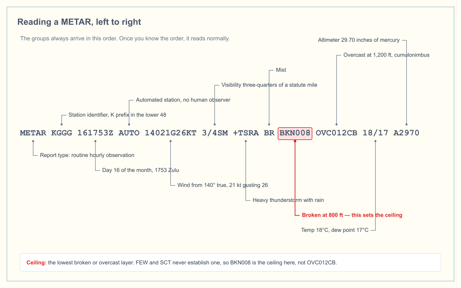
Three fingerprints in the coded report tell you an automated station made it, and all three show up in exam questions:
AUTOnear the front of the report means no human intervened. When an observer augments or backs up the station, the AUTO modifier disappears.AO1in remarks means an automated station without a precipitation discriminator.AO2means it has one and can tell liquid precipitation from frozen or freezing.SPECIinstead ofMETARmarks a special report issued off-schedule because something crossed a threshold — a new cloud layer below 1,000 feet, a thunderstorm beginning or ending, visibility changing through a reporting value.
The automated report carries limitations worth knowing. Reported visibility comes from a single sensor near the touchdown point of the primary instrument runway, converted using a 10-minute harmonic average. Sky condition comes from a ceilometer beside it, integrating the last 30 minutes of data. A human observer looks around and describes the whole sky; the machine describes the column of air above one point for the last half hour.
And because the sensors have a height limit, AWOS never says "clear." No clouds detected is announced as "no clouds below" or "clear below" a figure, where the figure is the range limit of the sensor. There could be a solid overcast above it. Our METAR reading guide works through the coded version group by group.
What this means when you are actually working
Under 14 CFR 107.49, the remote pilot in command must assess the operating environment before flight, and local weather conditions are the first item on that list. Four things change how you should use these broadcasts to do it.
Check the station's level before you trust the absence of a number. If an AWOS-1 does not mention the ceiling, that is not a clear sky. It is a station with no ceilometer.
The voice broadcast gives you magnetic wind, the written METAR gives you true. Wind direction is referenced to magnetic north in ATIS, ASOS and AWOS voice broadcasts, and to true north in the coded METAR text. In most of the continental US the variation is too small to change a launch decision, but it is a favorite exam distractor. The runway numbering article has the full source-by-source table.
The minute-by-minute update is the automated station's real advantage. An ATIS recording can be 50 minutes old and still be current by the rules. If you are watching a ceiling come down, the automated broadcast is a live feed and the ATIS is a snapshot.
The observation is from the airport, and you are not at the airport. Every one of these stations measures one point. Your launch site may be miles away, at a different elevation, on the other side of a ridge. Section 107.51 asks for 3 statute miles of flight visibility as observed from the control station, which means you, standing where you are standing, are the legal instrument. The AWOS is a cross-check on your own assessment, never a substitute for it.
How the exam asks about this
Weather is 5 percent of the Unmanned Aircraft General knowledge test under the blueprint effective 29 September 2025, so expect two or three weather questions in sixty. These systems appear in one of three shapes: a capability question that turns on the level table above, a decoding question about AUTO or AO2 in a METAR, or a chart question asking you to pull the weather frequency out of an airport data block.
That third shape gets more common after 27 October 2026, when chart extracts move into the question itself rather than a separate supplement book. Our article on the 2026 exam changes covers what else shifts.
Frequently asked questions
What do ASOS and AWOS stand for?
ASOS stands for Automated Surface Observing System and AWOS stands for Automated Weather Observing System. Both are unmanned sensor suites that measure local conditions and broadcast a synthesized voice report, and together they form the primary surface weather observing system of the United States under a joint NWS, FAA and Department of Defense program.
What is the difference between a METAR and an AWOS?
An AWOS is the physical station; a METAR is the coded report it produces. The station samples the environment continuously and performs the observing functions needed to generate the aviation routine weather report, which then goes out over national networks to your phone. The VHF voice broadcast is the same observation read aloud.
How often is ASOS updated?
An ASOS provides continuous minute-by-minute observations, and the voice broadcast is a 20 to 30 second message updated every minute. That is faster than ATIS, which is only required to update on receipt of an hourly or special observation. Routine METARs still go to the national network hourly, with SPECI reports issued off-schedule.
What is AWOS-3, and how is it different from AWOS-1?
AWOS-3 reports altimeter setting, wind, temperature, dew point, density altitude, visibility, and cloud and ceiling data. AWOS-1 omits the last two, because it has neither a visibility sensor nor a ceilometer. For a Part 107 flight that distinction is decisive, since 14 CFR 107.51 requires both a visibility figure and cloud clearance.
Do drone pilots need to listen to ATIS or AWOS?
Not specifically. 14 CFR 107.49 requires you to assess local weather conditions before flight but does not name a source, so a weather app satisfies it. Listening is still worth it, because the automated broadcast updates every minute and ATIS adds the active runway and field NOTAMs that tell you where manned traffic will be.
Which airports have ATIS and which have AWOS?
ATIS exists at selected high activity terminal areas, which in practice means towered fields with someone available to record it. AWOS and ASOS are automated and need no staff, so they appear at non-towered fields as well as towered ones. Check the WEATHER DATA SOURCES line in the Chart Supplement for any specific airport.
Want to find out whether the weather material has actually stuck? The free readiness assessment mixes weather questions in with the other four knowledge areas, so you see where you genuinely stand rather than where you feel confident.
Sources
- AIM 7-1-10 — Weather Observing Programs, including AWOS levels and ASOS
- AIM 4-1-13 — Automatic Terminal Information Service (ATIS)
- AIM 7-1-2 — FAA Weather Services, including SPECI issuance criteria
- 14 CFR 107.49 — Preflight familiarization, inspection, and actions for aircraft operation
- 14 CFR 107.51 — Operating limitations for small unmanned aircraft
- FAA Airman Certification Standards
- FAA Chart Supplement
Put this guide into practice.
Take the free assessment to see how this topic fits into your current exam readiness.
Start free practice