Weather
How to Read Wind Barbs on an Aviation Weather Chart
A wind barb is four symbols and one direction convention. Here is how to read speed and direction off a chart, and why the number on the chart is not the number the tower reads you.
Key takeaway
Add the parts on the staff — pennant 50 knots, full barb 10, half barb 5 — and read the staff as pointing toward the direction the wind is coming from. Chart winds are referenced to true north; ATIS and AWOS voice broadcasts are magnetic.
A wind barb shows wind speed and direction with one line and a few marks. Add the parts on the staff: each pennant is 50 knots, each full barb is 10 knots, and each half barb is 5 knots. The staff points toward the direction the wind is blowing from, referenced to true north. A bare circle over the station means calm.
That is the whole system, and it takes about a minute to learn. What takes longer is knowing which chart you are looking at, what the rest of the symbols around the barb mean, and why the direction printed on the chart will not match the direction a tower controller reads to a pilot ten miles away. Those are the parts that change a decision.
How do you read a wind barb?
A barb has three components, and you read them from the station outward.
| Symbol | Value | What it looks like |
|---|---|---|
| Half barb | 5 knots | A short line at an angle to the staff |
| Full barb | 10 knots | A long line at an angle to the staff |
| Pennant | 50 knots | A filled triangle |
| Bare circle, no staff | Calm | The station circle on its own |
The FAA Aviation Weather Handbook puts it plainly: wind speed is determined by adding the values of the flags at 50 knots, the barbs at 10 knots, and the half barbs at 5 knots found on the stem, and if the wind is calm at the time of observation only a single circle over the station is depicted.
Wind is plotted in increments of 5 knots. There is no symbol for 7 knots. What you are reading is a rounded value, which matters when you are close to a limit.
Which direction does a wind barb point?
The staff points toward the direction the wind is coming from, not the direction it is heading. This trips people up because every other arrow on a map points the way something is going.
Think of the barbs as the feathers on an arrow. Feathers sit at the tail. The tail is upwind. So a staff running from the station circle up toward the top of the chart, with the barbs at the top end, is a wind out of the north.
A useful habit: say the direction out loud as a compass bearing before you say the speed. "Out of the northwest, twenty-five knots." Getting direction and speed in that order is the same order the METAR wind group uses, so the two products stop competing in your head.
How do you work out the wind speed?
Add every mark on the staff. Some worked examples:
| Marks on the staff | Speed |
|---|---|
| One half barb | 5 knots |
| One full barb | 10 knots |
| One full barb and one half barb | 15 knots |
| Two full barbs and one half barb | 25 knots |
| One pennant | 50 knots |
| One pennant, two full barbs, one half barb | 75 knots |
Count the pennants first, then the full barbs, then look for the half barb, which is easy to miss at chart scale because it is drawn short and often sits at the far end of the staff. Missing a half barb is a 5-knot error. Missing a pennant is a 50-knot error, and at the surface that is the difference between a working day and a chart you should not be flying under at all.
True north or magnetic north?
This is the detail that separates people who have read a chart from people who have flown with one.
Winds on charts and in written reports are referenced to true north. The AIM states that the METAR wind direction is given in tens of degrees referenced to true north, and that forecast winds aloft are provided in knots and degrees referenced to true north. The Aviation Weather Handbook says the same for the surface analysis station plot.
Winds you hear over a radio are magnetic. The AIM is explicit: wind direction is reported relative to magnetic north in ATIS as well as ASOS and AWOS radio voice broadcasts.
So the same wind at the same field is described with two different numbers depending on where you read it. In parts of the country the magnetic variation is small enough to ignore. In others it is well over ten degrees, which is enough to change which runway is favored and therefore which way traffic will be arriving over your launch site. This is the same variation that explains why runway numbers are magnetic while the chart around them is not.
For a remote pilot the practical rule is short: if you read it, it is true; if you heard it, it is magnetic.
Where do wind barbs actually appear?
Three products you are likely to meet.
The surface analysis chart. Issued by the Weather Prediction Center for North America eight times daily, valid at 00, 03, 06, 09, 12, 15, 18 and 21 UTC. Barbs sit on station plots scattered across the map, alongside the isobars and the frontal symbols.
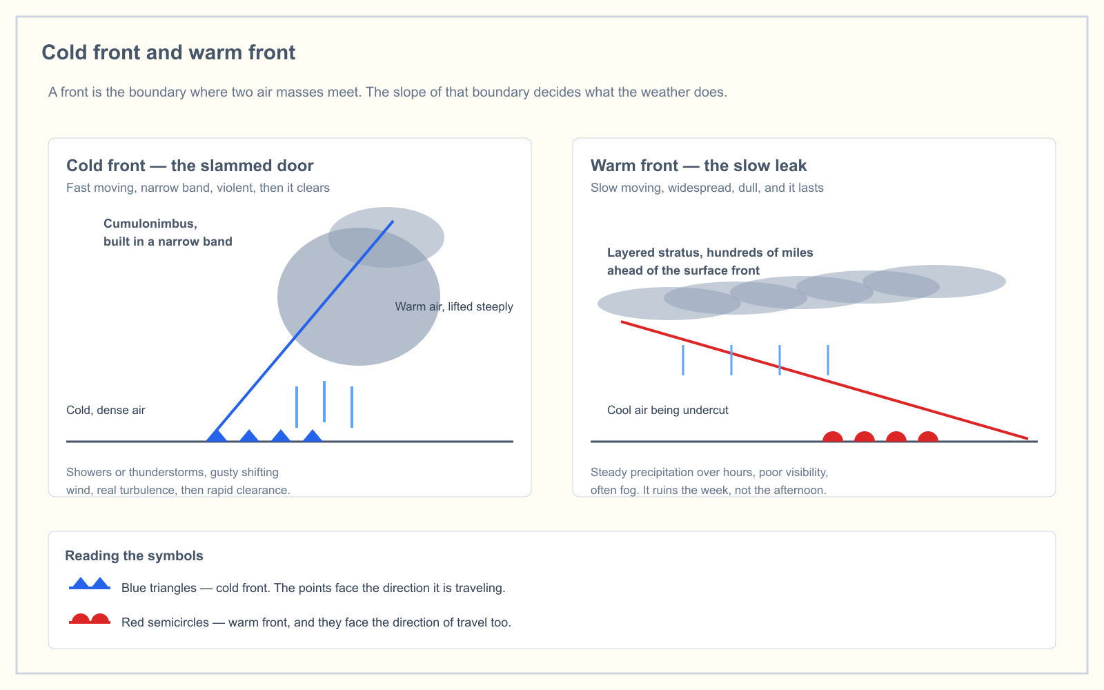
Reading the barbs against the frontal symbols is where the chart earns its keep. A front is a wind shift line by definition, so the barbs on either side of one should disagree. If they do, you can see which way the shift will run when the boundary reaches you.
Graphical winds aloft. Winds aloft forecasts are issued at selected flight levels in chart and grid point formats, with speed and direction displayed as wind barbs referenced to true north.
Constant pressure charts. At 300, 250 and 200 millibars the barbs show the jet stream, with shading typically applied above 70 knots. Not your altitude, but it tells you what is steering the systems that will be your altitude in two days.
Reading the rest of the station model
The barb is one element of a station plot. On the surface analysis chart produced specifically for aviation, the surrounding fields are:
| Element | How it is plotted |
|---|---|
| Temperature | Whole degrees Fahrenheit |
| Dewpoint | Whole degrees Fahrenheit |
| Ceiling | Hundreds of feet AGL |
| Visibility | Whole statute miles |
| Sea level pressure | Tenths of millibars, leading 10 or 9 omitted |
| Sky cover | The fill of the station circle |
| Weather | A symbol, plotted only when precipitation or a visibility restriction exists |
Two of those catch people out. Temperature and dewpoint are in Fahrenheit on this chart, while a METAR gives you Celsius, so do not carry a number between the two products without converting. And the pressure is abbreviated: 103 means 1,010.3 millibars, 987 means 998.7. The handbook notes 1,013 millibars is equivalent to 29.92 inches of mercury, which is the anchor worth remembering when you are working a density altitude problem.
The text version: the FB winds aloft forecast
Not every wind product uses barbs. The FB Wind and Temperature Aloft Forecast is text, coded as DDff+TT, where direction is tens of degrees true, speed is knots, and temperature is Celsius. Its quirks:
- 9900 means light and variable, or under 5 knots.
- Speeds of 100 to 199 knots are coded by adding 50 to the direction digits and subtracting 100 from the speed. A forecast of 250 degrees at 145 knots becomes 7545.
- Speeds of 200 knots or more are coded as 199.
- Winds are not forecast within 1,500 feet of the location's elevation, and temperatures are not forecast within 2,500 feet of it.
That last point matters more to a drone pilot than any other line in this article. The lowest FB level is 3,000 feet, and nothing is forecast near the surface. No wind barb and no winds aloft forecast tells you the wind at 200 feet AGL. They tell you the pattern. The wind at your altitude comes from a surface observation, from what the trees are doing, and from putting the aircraft up and watching what it has to fight.
What wind actually changes for a multirotor
There is no wind limit in Part 107. Section 107.51 caps groundspeed at 87 knots, altitude at 400 feet AGL, and sets the visibility and cloud clearance figures, but it says nothing about wind. The limits that bind you are the aircraft's published maximum wind resistance and 14 CFR 107.49(a)(1), which requires the remote pilot in command to assess local weather conditions before flight.
Four things wind does to a battery-powered aircraft:
It spends your endurance asymmetrically. Fly the outbound leg downwind and the aircraft is fast, quiet and cheap. The return leg is into the wind at reduced groundspeed and much higher power draw, and it happens on the depleted half of the battery. Plan the upwind leg first.
Gusts matter more than the sustained figure. A steady 18 knots is a stable hover with a tilted aircraft. A 10-knot wind gusting 22 is repeated attitude corrections, and on a camera job it is the difference between usable footage and a day wasted.
Obstacles make their own turbulence. The Aviation Weather Handbook describes mechanical turbulence as the eddies produced by obstructions to wind flow such as trees and buildings, with intensity depending on wind speed, surface roughness, obstruction size and the stability of the air, and with the eddies carried downstream. The lee side of the tree line at the edge of your site is rougher air than the open field, and low, slow and close to structures is exactly where you work.
Wind and heat compound. A hot afternoon that has already cost you rotor efficiency is the same afternoon with the strongest surface wind. Neither alone ends the flight; together they can.
Frequently asked questions
What does each line on a wind barb mean?
Each half barb represents 5 knots, each full barb represents 10 knots, and each pennant, drawn as a filled triangle, represents 50 knots. Add every mark on the staff to get the total wind speed. Speeds are plotted in 5-knot increments, so the value you read is rounded rather than exact.
Which direction does a wind barb point?
The staff points toward the direction the wind is blowing from, not the direction it is traveling toward. A staff extending north from the station circle indicates a north wind. Treat the barbs as feathers on an arrow: they sit at the tail, and the tail is always the upwind end.
What does a circle with no barb mean on a weather chart?
A single circle drawn at the station with no staff attached indicates calm wind at the time of observation. The fill of that same circle separately reports sky cover, so a station can show calm wind and an overcast sky at once. It is the absence of the staff, not the circle itself, that means calm.
Are wind barbs true north or magnetic north?
True north. Chart wind barbs, METAR wind groups and winds aloft forecasts are all referenced to true north. Wind directions broadcast by voice over ATIS, ASOS and AWOS are referenced to magnetic north, so the same wind carries two different numbers depending on whether you read it or heard it.
Do wind barbs show the wind at drone altitude?
No. Surface analysis barbs report the observed surface wind at a specific station, which may be many miles away, and the FB winds aloft forecast starts at 3,000 feet and issues nothing within 1,500 feet of a location's elevation. For the wind at 200 feet AGL you need a local surface observation and your own on-site assessment.
Is there a maximum wind speed for flying a drone under Part 107?
Part 107 sets no wind limit. Section 107.51 limits groundspeed, altitude, visibility and cloud clearance only. Your constraints are the manufacturer's published maximum wind resistance for the aircraft and the preflight assessment of local weather conditions that 14 CFR 107.49(a)(1) requires before every flight.
Chart reading is the part of the knowledge test people underestimate. The free readiness assessment mixes weather and chart questions with the other knowledge areas, so you find out which one is actually costing you marks.
Sources
- FAA-H-8083-28B, Aviation Weather Handbook — Chapter 25, Analysis, and Chapter 27, Forecasts
- Aeronautical Information Manual, Chapter 7 Section 1 — Meteorology
- 14 CFR 107.49 — Preflight familiarization, inspection, and actions for aircraft operation
- 14 CFR 107.51 — Operating limitations for small unmanned aircraft
- National Weather Service — Wind barb information
- NWS Weather Prediction Center — Surface analysis charts
Put this guide into practice.
Take the free assessment to see how this topic fits into your current exam readiness.
Start free practice