Weather
Cloud Types in Aviation: What Each One Tells a Remote Pilot
Cirrus, stratus, cumulus and the rest, classified the way the current FAA Aviation Weather Handbook actually does it, then tied to the decision you have to make on the ground.
Key takeaway
The FAA divides clouds into three levels by base height and four forms by appearance. Only broken and overcast layers set a ceiling, and only cloud base height decides whether 14 CFR 107.51 lets you launch.
The FAA's Aviation Weather Handbook divides clouds into three levels by the height of their bases — high, middle and low — and four forms by appearance: cirriform, cumuliform, stratiform and nimboform. In temperate regions low bases run from the surface to 6,500 feet, middle from 6,500 to 23,000 feet, and high from 16,500 to 40,000 feet.
Most cloud articles written for pilots say there are four families, the fourth being "clouds with extensive vertical development." That framing comes from older material. The current handbook does not use it. It classifies cumulonimbus and towering cumulus as low clouds, because classification follows the height of the cloud's base, not its top. If you learned the four-family version, this is the correction worth making.
What are the different types of clouds according to the FAA?
Two systems run at the same time, and they answer different questions. Level tells you how high the base is. Form tells you what the cloud looks like and therefore what the air is doing.
| Form | What it looks like | What it means |
|---|---|---|
| Cirriform | Thin, white, wispy, mostly ice crystals | High altitude, fair weather, points along the wind at its level |
| Cumuliform | Heaped, cotton-like, flat base and domed top | Rising air, instability, turbulence |
| Stratiform | Featureless layer covering the sky like a blanket | Stable air, poor visibility, low ceilings |
| Nimboform | Dark and thick, precipitation falling from it | Steady precipitation; the base lowers as it thickens |
The levels overlap, and their limits shift with latitude. These are the temperate-region figures, which is what applies across the continental United States:
| Level | Approximate base height |
|---|---|
| High clouds | 16,500 to 40,000 ft |
| Middle clouds | 6,500 to 23,000 ft |
| Low clouds | Surface to 6,500 ft |
Nothing on that list is at your altitude. You are capped at 400 feet AGL by 14 CFR 107.51. Even the lowest category starts at the surface and runs well above you, which is exactly why cloud base height is the number that decides your flight.
The prefixes, and what each one tells you
Cloud names are built from parts. Learn five and you can decode a name you have never seen.
- Cirro- — high level, ice crystals
- Alto- — middle level
- Strato- — layered, spread out flat
- Cumulo- — heaped, vertically developed
- Nimbo- or the suffix -nimbus — precipitation is falling from it
So altostratus is a middle-level flat layer. Cirrocumulus is a high-level heaped cloud. Cumulonimbus is a heaped cloud that has grown tall enough to rain, which is the formal name for a thunderstorm cell.
The one that trips people up is nimbostratus. The name says layer plus precipitation, and its base often sags into low-cloud heights during steady rain. The handbook addresses this directly: it is officially and historically classified as a middle cloud, even though some cloud charts show it as low.
High clouds: cirrus, cirrocumulus, cirrostratus
Cirrus (Ci), cirrocumulus (Cc) and cirrostratus (Cs). Thin, white, composed almost entirely of ice crystals. Cirrus often trails downward in wisps called mares' tails.
For a remote pilot these are essentially decoration. The handbook notes that cirrus clouds in themselves have little effect on aircraft and contain no significant icing or turbulence. They are far above you, they do not set a ceiling that matters, and they never make you scrub. Their value is as a signal: a thickening cirrostratus layer is often the leading edge of an approaching warm front, which means the weather in twelve hours is not the weather now. That connection is covered in more depth in the four types of weather fronts.
Middle clouds: altocumulus, altostratus, nimbostratus
Altocumulus (Ac), altostratus (As) and nimbostratus (Ns), composed mostly of water droplets, sometimes supercooled.
Altocumulus is patchy and rippled, and the handbook says pilots flying through it can expect some turbulence and small amounts of icing. Altostratus is a thicker gray sheet. Unlike most clouds, altostratus and nimbostratus grow by lowering their base rather than building upward, which is the detail that matters on the ground — a middle-level deck that looks harmless at noon can be a low ceiling by mid-afternoon without anything dramatic happening.
Nimbostratus is the steady-rain cloud. No lightning, no thunder, no hail, very little turbulence, but thick enough to blot out the sun and deep enough that it has no well-defined base.
Low clouds: cumulus, stratocumulus, stratus, and the two that end the flight
Cumulus (Cu), towering cumulus (TCu), stratocumulus (Sc), stratus (St) and cumulonimbus (Cb). This is the group that governs whether you fly.
Fair weather cumulus has clear-cut horizontal bases and flat or slightly rounded tops. It forms over land on clear mornings as the sun heats the ground. Expect some turbulence and no significant icing. It is a sign of unstable air, which usually means good visibility and a bumpy ride — the tradeoff explained in stable vs unstable air.
Stratus is the most frequent cloud associated with low ceilings. It is a gray, featureless layer with bases usually only a few hundred feet above the ground. When it reaches ground level it is fog, and the same cloud is reported as stratus from the valley and as fog from the hilltop. That relationship is worked through in the types of fog.
Stratocumulus is the in-between case, a gray layer broken into rounded rolls or patches.
Then the two that matter most:
Towering cumulus (TCu) is cumulus of moderate to strong development, and the handbook is blunt about it — pilots can expect very strong turbulence and some clear icing above the freezing level. It is also described as the first stage of a thunderstorm. TCU is not a cloud you wait out at the launch site. It is a cloud you pack up for.
Cumulonimbus (Cb) is the mature product: exceptionally dense, vertically developed, often topped with an anvil, with virga and ragged low cloud beneath a very dark base. The handbook's summary is the sentence worth memorizing — cumulonimbus contains nearly the entire spectrum of flying hazards, including extreme turbulence. The stages it passes through, and the downdraft that makes it dangerous to something as light as a drone, are covered in thunderstorm stages and the microburst.
Which layer is the ceiling, and why only two of them count
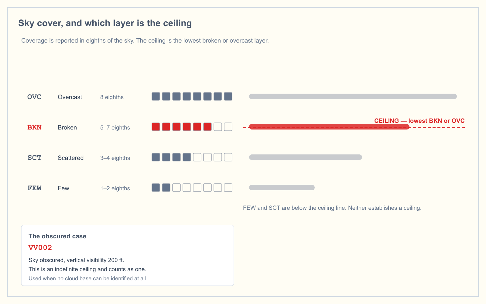
Cloud coverage is reported in eighths of the sky:
| Contraction | Meaning | Coverage |
|---|---|---|
| SKC or CLR | Clear | 0 |
| FEW | Few | 1/8 to 2/8 |
| SCT | Scattered | 3/8 to 4/8 |
| BKN | Broken | 5/8 to 7/8 |
| OVC | Overcast | 8/8 |
| VV | Vertical visibility | Indefinite ceiling |
The FAA Pilot/Controller Glossary defines the ceiling as the height of the lowest layer reported as broken, overcast or obscuration, and not classified as thin or partial. FEW and SCT never establish a ceiling. A field reporting FEW008 SCT015 BKN040 has a ceiling of 4,000 feet, not 800.
At manual stations, cumulonimbus or towering cumulus is appended to the layer it belongs to. SCT015TCU is a scattered layer of towering cumulus at 1,500 feet. That suffix is the single most useful thing in a METAR for a drone operator, because it tells you the cloud type without you having to look up. Reading the rest of the report group by group is covered in how to read a METAR.
What cloud type actually changes about a Part 107 flight
Here is the part the manned-pilot articles skip. You are not flying into these clouds. You are standing underneath them at 400 feet or less. Cloud type changes three things.
It sets your legal ceiling. Section 107.51 requires you to stay 500 feet below and 2,000 feet horizontally from any cloud, and to have 3 statute miles of flight visibility from the control station. A base at 800 feet caps you at 300 feet AGL. A base at 400 feet grounds you outright. The cloud type tells you which way that base is about to move: a cumuliform base tends to hold or lift as the day heats, while a thickening altostratus or nimbostratus base descends. The full set of figures is in VFR weather minimums.
It predicts the air you will fly in. Cumuliform means convection, which means updrafts, downdrafts and gusty surface wind. A small multirotor holding position under building cumulus will burn noticeably more battery fighting to stay put. Stratiform means smooth air and poor visibility, which is the opposite problem: comfortable flying, but you may lose visual line of sight before you reach the distance you planned.
It decides whether you launch at all. Fair weather cumulus is a normal working day. Towering cumulus is not, and there is no version of a Part 107 operation where flying beneath a cumulonimbus is defensible. The hazard arrives before the storm does. A microburst can put damaging outflow miles ahead of a cell that still looks comfortably distant.
How the exam asks about clouds
Weather is 5 percent of the Unmanned Aircraft General knowledge test under the blueprint effective 29 September 2025, so this is not where the exam is won. Cloud questions tend to take three shapes: identifying which cloud indicates unstable air or turbulence, converting a reported layer into a legal maximum altitude under 107.51, and picking the ceiling out of a multi-layer METAR. The second and third are really arithmetic questions wearing a weather costume, and they are worth more marks than cloud naming.
You can drill the METAR-to-altitude version directly in the METAR practice trainer.
Frequently asked questions
What are the four types of clouds?
The FAA Aviation Weather Handbook lists four cloud forms, not types: cirriform, cumuliform, stratiform and nimboform. Older material describes four families — high, middle, low, and clouds with extensive vertical development — but the current handbook uses only three levels and places vertically developed clouds in the low group.
What are 10 different types of clouds?
The ten genera the handbook defines are cirrus, cirrocumulus and cirrostratus at the high level; altocumulus, altostratus and nimbostratus at the middle level; and cumulus, stratocumulus, stratus and cumulonimbus at the low level. Towering cumulus is treated alongside cumulus as a stage of its development.
Are cumulonimbus clouds high or low clouds?
Low. The handbook groups cumulonimbus and towering cumulus with the low clouds because classification follows the height of the cloud base, and their bases usually sit below 6,500 feet. Their tops routinely reach the middle and high levels, which is why the four-family version listed them separately.
What cloud types mean you should not launch?
Cumulonimbus and towering cumulus. The handbook says towering cumulus produces very strong turbulence and describes it as the first stage of a thunderstorm, and that cumulonimbus contains nearly the entire spectrum of flying hazards including extreme turbulence. Both can generate damaging outflow well ahead of any visible precipitation.
Does Part 107 let you fly through a cloud?
No. Section 107.51(d) requires a small unmanned aircraft to remain at least 500 feet below and 2,000 feet horizontally from any cloud. There is no distance specified for flying above a cloud, because the 400-foot altitude limit makes it a situation you should not encounter.
What does TCU mean in a METAR?
TCU is towering cumulus, appended to the sky cover layer it belongs to at manual reporting stations. SCT015TCU means a scattered layer of towering cumulus at 1,500 feet AGL. CB is used the same way for cumulonimbus. Either suffix is a direct signal to reconsider the flight.
Want to know whether the weather questions are actually costing you marks? The free readiness assessment mixes them in with the other four knowledge areas so you find out where you really stand.
Sources
Put this guide into practice.
Take the free assessment to see how this topic fits into your current exam readiness.
Start free practice