Weather
Mountain Wave Turbulence: The Rotor Under the Ridge
The FAA tells you to anticipate a mountain wave when winds of 40 knots or greater cross a ridge and the air is stable. The violent part forms below the summits, in the layer a small drone occupies.
Key takeaway
The rotor forms below the elevation of the mountain peaks, so a drone on the lee side of a ridge is inside the most turbulent part of the wave, not above it.
Mountain wave turbulence is the standing wave pattern that forms downwind when stable air is forced across a ridge. The FAA's rule of thumb is to anticipate it whenever winds of 40 knots or greater blow across a mountain or ridge and the air is stable. The most violent region, the rotor, forms below the elevation of the peaks.
That last sentence is the whole reason this article exists. Almost everything written about mountain waves is written for someone in a Cessna crossing a ridge, and the standard advice given to that pilot is to cross well above the crest, where the flow is still smooth. A remote pilot cannot take that advice. You are pinned to 400 feet above ground level by 14 CFR 107.51(b), which puts your aircraft in the one layer the manned pilot is being told to climb out of.
What is mountain wave turbulence?
When stable air crosses a barrier, the flow stays laminar. It moves in layers rather than churning, and the barrier sets up waves in those layers much as a submerged rock sets up standing waves in a river. The waves stay nearly stationary while the air rushes through them, which is why the FAA calls the result a standing wave.
The wave train can extend 100 miles or more downwind of the barrier, and the crests reach well above the highest terrain, sometimes into the lower stratosphere. So this is not a hazard that lives on the mountain. It lives downwind of it, over ground that may look completely flat.
Underneath each wave crest sits a rotary circulation, and that is the rotor. The FAA's description of it is blunt: turbulence can be violent in the overturning rotor.
When should you expect mountain wave turbulence?
Three things have to line up. Miss any one and you get ordinary mechanical turbulence instead of an organized wave.
| Condition | What it takes | Why it matters |
|---|---|---|
| Wind speed | 25 knots at ridge level suggests turbulence; 40 knots or greater dictates caution | Supplies the energy for the wave train |
| Wind direction | Roughly perpendicular to the ridge line | A wind running parallel to the ridge is not forced over it |
| Stability | A stable layer at and above ridge height | Makes the parcel sink back after being lifted, which is what oscillates |
The FAA's long-standing formulation is worth memorizing as written, because the knowledge test uses it almost verbatim: always anticipate possible mountain wave turbulence when strong winds of 40 knots or greater blow across a mountain or ridge and the air is stable.
Note what is not on that list. Wave formation does not require a large mountain range. A ridge line, a line of bluffs or a steep escarpment will do it if the wind is strong enough and perpendicular enough.
Why stability is the condition people skip
Stability is the counterintuitive half. Instinct says turbulence needs churning, unstable air, so a stable atmosphere ought to be the safe one.
It works the other way here. In unstable air a lifted parcel keeps rising and the energy dissipates through vertical mixing, so hazardous turbulence generally does not extend far downwind of the barrier. In stable air the parcel is pushed back down, overshoots, gets pushed back up, and keeps oscillating. Stability is what lets the wave propagate for a hundred miles instead of dying out behind the ridge.
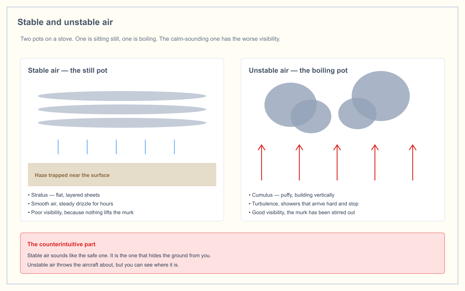
If you want the full picture of what stability does to cloud, visibility and turbulence, that is covered in stable vs unstable air.
Why the rotor is the remote pilot's problem
Here is the geometry that matters. The rotor forms below the elevation of the mountain peaks, directly under each wave crest. A manned pilot reads that and hears "stay high." A remote pilot should hear something else.
Picture a ridge standing 1,500 feet above the valley on its lee side. The rotor zone occupies the air below summit height, which means it fills the valley. Your aircraft, capped at 400 feet AGL, is not underneath the rotor. It is inside it.
The severity is not theoretical. FAA Advisory Circular 00-57 states that the airspace near and below a rotor cloud frequently contains severe-to-extreme turbulence and should be avoided outright.
Then there is the vertical motion. National Weather Service turbulence training material puts the displacement in the main updraft and downdraft of a wave at up to 5,000 feet per minute. A typical small multirotor climbs at 1,000 to 1,500 feet per minute at sea level, and less on a hot day at altitude where density altitude has already eaten into its performance. You cannot outclimb a downdraft moving three times faster than your best rate of climb. The aircraft descends regardless of what the motors are doing.
Is there more turbulence over mountains?
Yes, but not evenly, and the asymmetry is the useful part.
The windward slope is usually the smooth side. Air flowing up it is lifted steadily and laminarly, and the ride there can be deceptively pleasant. The hazard is concentrated on the lee side: the downslope flow, the wave train downwind, and the rotor beneath the crests.
That produces a real trap for a crew working a site. You can fly the windward side of a ridge all morning in smooth air, form a reasonable belief that conditions are fine, then reposition 2 miles to the other side of the same ridge into severe turbulence with no change in the weather whatsoever.
What clouds mark a mountain wave, and the trap in the question
When there is enough moisture, the wave draws its own diagram in the sky.
| Cloud | Where it sits | What it tells you |
|---|---|---|
| Standing lenticular altocumulus (ACSL) | On the wave crests, above peak height | Smooth, polished, lens-shaped, and stationary. A good indication of very strong turbulence |
| Rotor cloud | Below the crests, near peak height or lower | Ragged and visibly churning. Marks the most intense turbulence |
| Foehn or wall cloud | Draped over the ridge itself | Stable air being forced up and over the barrier |
Lenticulars look painted on. They form continuously in the updraft and dissipate in the downdraft, so the cloud holds position while the air moves through it at 40 knots or more. For the wider cloud vocabulary, see cloud types in aviation.
Now the trap, which people search for as a statement they are trying to confirm: the presence of mountain wave turbulence is always accompanied by lenticular clouds.
It is false. The FAA is explicit that clouds are not always present to mark the mountain wave, because sometimes the air is too dry. Moisture makes the wave visible; it has nothing to do with whether the wave exists. A clear blue sky over a ridge with 45 knots of perpendicular wind and a stable layer is not evidence of calm air. It is the same wave with the labels removed, and more dangerous for exactly that reason.
How a mountain wave reaches you before you launch
You are not going to get a product that says "mountain wave over your field." You get fragments, and you assemble them.
- AIRMET Tango covers moderate turbulence, strong surface winds and low-level wind shear. Severe turbulence exceeds the AIRMET threshold and moves to a SIGMET instead. Over the lower 48 these are graphical-only products now, which is covered in AIRMET vs SIGMET.
- PIREPs are the highest-value source here, because turbulence is essentially only observable by being flown through. A report of moderate or severe turbulence in the lee of terrain is a direct observation of the thing you care about.
- METARs can carry ACSL or rotor clouds in the remarks, which AC 00-57 identifies as evidence of wave activity. The caveat is real: automated stations are replacing human observers at many fields, and an automated station does not report cloud type at all. See how to read a METAR.
- Winds aloft are the cheapest check of all. If the forecast wind at ridge level is 40 knots and crosswise to the terrain, you have two of the three conditions before you have looked at anything else.
What this means when you are actually working
14 CFR 107.49 requires you to assess the operating environment, including weather, before every flight. Near terrain, that assessment has a specific shape.
Establish the ridge orientation and the wind direction. Perpendicular is the dangerous case. A wind running along the ridge rather than across it largely removes the wave mechanism.
Treat the lee side as a different site from the windward side, even when it is the same job and the same field. Conditions do not transfer across the ridge line.
Watch the surface for what you cannot see aloft. Dust plumes lifting and rotating, or a persistent strong surface wind under a clear sky with no thunderstorm anywhere, are both consistent with wave activity reaching the ground.
Respect a stationary lens-shaped cloud. It means the flow is already strong enough to hold a cloud still.
The honest answer, most of the time, is not to fly. A small unmanned aircraft has very little margin against severe turbulence, and there is no piloting technique that recovers a 2-pound airframe from inside a rotor.
How the exam asks about mountain waves
Weather is 5 percent of the current UAG blueprint, so this is a small slice, but the questions are formulaic and therefore free marks. They come in three shapes:
- The conditions question. Something close to "possible mountain wave turbulence could be anticipated when winds of 40 knots or greater blow across a mountain ridge and the air is..." The answer is stable. The distractor is unstable, and it is chosen constantly.
- The cloud question. What does a standing lenticular altocumulus indicate? Strong turbulence, and the cloud does not move.
- The location question. Where is the turbulence worst? In and below the rotor, on the lee side, beneath the wave crests. Not on the windward slope.
The free readiness assessment mixes weather questions in with the other four knowledge areas so you can see whether the weakness is actually here or somewhere else.
Frequently asked questions
What is mountain wave turbulence?
Mountain wave turbulence is the turbulence produced by a standing wave pattern that forms when stable air is forced across a mountain or ridge. The waves remain nearly stationary while the wind blows through them, and they can extend 100 miles or more downwind of the barrier that created them.
When should you expect mountain wave turbulence?
Anticipate it when winds of 40 knots or greater blow across a mountain or ridge and the air is stable. Wind at ridge level above 25 knots already suggests some turbulence. The wind must be roughly perpendicular to the ridge line, and wind speed increasing with height makes wave formation more likely.
Is mountain wave turbulence always accompanied by lenticular clouds?
No. Lenticular clouds only form when there is enough moisture for condensation at the wave crests. The FAA is explicit that clouds are not always present to mark a mountain wave, because the air is sometimes too dry. A clear sky is not evidence that the wave is absent.
Where is mountain wave turbulence worst?
In and near the rotor, which forms below the elevation of the mountain peaks under each wave crest, on the lee side of the barrier. FAA Advisory Circular 00-57 states that the airspace near and below a rotor cloud frequently contains severe-to-extreme turbulence and should be avoided.
How far downwind does a mountain wave extend?
The wave pattern may extend 100 miles or more downwind of the barrier. This is why a site on flat ground well away from any visible terrain can still sit inside an active wave train, and why the absence of mountains at the launch point is not by itself reassuring.
Can a small drone fly safely in a mountain wave?
Generally no. Vertical motion in the main wave updraft and downdraft can reach 5,000 feet per minute, which is several times the climb rate of a typical small multirotor, and the rotor zone occupies the altitudes a drone is legally confined to. The correct decision is usually to postpone.
Sources
- FAA-H-8083-28B, Aviation Weather Handbook
- FAA AC 00-57 — Hazardous Mountain Winds and Their Visual Indicators
- FAA AC 00-6A — Aviation Weather, Chapters 7 to 9 (turbulence and clouds)
- AIM Chapter 7, Section 1 — Meteorology
- 14 CFR 107.51 — Operating limitations for small unmanned aircraft
- 14 CFR 107.49 — Preflight familiarization, inspection, and actions for aircraft operation
- National Weather Service — Turbulence training material
Put this guide into practice.
Take the free assessment to see how this topic fits into your current exam readiness.
Start free practice